Great Shefford
Great Shefford (or West Shefford) is an English village and civil parish on the River Lambourn in the West Berkshire district of Berkshire. The present civil parish includes the historical parish of Little or East Shefford, a small, reduced community downstream. It also covers the village of Shefford Woodlands, about 1.5 miles (2.4 km) south-west of Great Shefford, near Junction 14 on the M4 motorway.
| Great Shefford | |
|---|---|
| Village | |
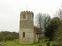 St Mary's parish church | |
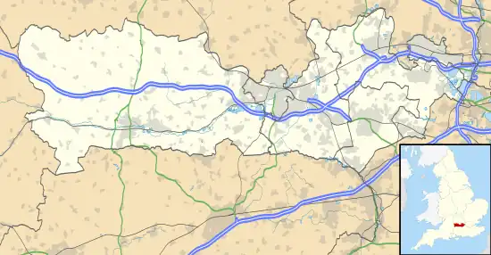 Great Shefford Location within Berkshire | |
| Area | 13.6 km2 (5.3 sq mi) |
| Population | 937 (2011 census)[1] |
| • Density | 69/km2 (180/sq mi) |
| OS grid reference | SU3875 |
| Civil parish |
|
| Unitary authority | |
| Ceremonial county | |
| Region | |
| Country | England |
| Sovereign state | United Kingdom |
| Post town | Hungerford |
| Postcode district | RG17 |
| Dialling code | 01488 |
| Police | Thames Valley |
| Fire | Royal Berkshire |
| Ambulance | South Central |
| UK Parliament | |
| Website | Great Shefford and Shefford Woodlands |
Toponymy
The toponym of the Sheffords derives from the Old English for sheep ford.
Amenities
Great Shefford village has a primary school that belongs to Chaddleworth St. Andrew's and Shefford Church of England Federated Primary Schools. It also has a pub-restaurant, The Great Shefford,[2] a shop and a petrol station.
Churches
St Mary
The Church of England parish church of St Mary is one of two existing round-tower churches in Berkshire. The other is St Gregory's parish church at nearby Welford. Unlike the three round-towered churches in Sussex, where the towers are plain flint cylinders with few openings, the Great Shefford one consists of sections with ample fenestration, more like the East Anglian type. The base of the tower, at least, seems to date from the 13th century. It joins the west wall of the nave in a way that suggests it was built at the same time as the nave, which shows early Gothic features. St Mary's belongs to the West Downland benefice group of eight neighbouring churches. Services are held at St Mary's on the first, second and third Sunday of the month.[3] A group service is held at St Stephen's on the fourth Sunday of the month.[3] St Mary's is a Grade II* listed building.[4]
St Stephen
The church of Saint Stephen at Shefford Woodlands is a former Methodist chapel, taken over as part of Saint Mary Church of England parish church in 1911.[5] The church is a Grade II listed building.[6]
St Thomas
St Thomas' Church, East Shefford is a redundant church, but listed as a Grade I historic building. It contains monuments to the widespread Fettiplace family.[7]
Notable people
- Richard Brydges (1500–1558), politician, owned and lived at Great Shefford Manor.
- Clive Bell (1881–1964), art critic, was born in East Shefford.
- Harold Balfour, 1st Baron Balfour of Inchrye (1897–1988), Conservative MP and Privy Councillor, died in Great Shefford.
- Brian Cheesman (born 1929), international cricketer, was born in Shefford Woodlands.
Transport
Reading Buses route 4 (Newbury–Lambourn) serves Great Shefford.[8] From 1898 until 1960 the parish included Great Shefford railway station on the Lambourn Valley Railway. The nearest station today is Newbury, 10.5 miles/16 km away. The north-south A338 between Wantage and Hungerford runs through the village and connects to Junction 14 on the M4 motorway.
Demography
The 2011 Census recorded a parish population of 937,[9] and 880 are listed on the Millennium Stone opposite the petrol station. The population had grown by about 5 per cent since the 2011 census.
| Output area | Homes owned outright | Owned with a loan | Socially rented | Privately rented | Other | km2 roads | km2 water | km2 domestic gardens | Usual residents | km2 |
|---|---|---|---|---|---|---|---|---|---|---|
| Civil parish | 126 | 146 | 50 | 70 | 9 | 0.258 | 0.039 | 0.246 | 937 | 13.6 |
References
- "Key Statistics: Dwellings; Quick Statistics: Population Density; Physical Environment: Land Use Survey 2005". Archived from the original on 11 February 2003. Retrieved 20 July 2010.
- Own site.
- A Church Near You. Retrieved 5 December 2018.
- Historic England (6 February 1962). "Church of St Mary (Grade II*) (1113644)". National Heritage List for England.
- "History of Great Shefford". Great Shefford and Shefford Woodlands. The Parish of Great Shefford. Archived from the original on 23 July 2013. Retrieved 23 July 2013.
- Historic England (19 October 2015). "Church of St Stephen (Grade II) (1430002)". National Heritage List for England.
- Historic England (11 July 1983). "St Thomas' Church (Grade I) (1321841)". National Heritage List for England.
- "Connect Service 4" (pdf). Timetables. Newbury and District Buses. Retrieved 23 July 2013.
- Population site Retrieved 11 July 2018.
Sources
- Page, W. H.; Ditchfield, P.H., eds. (1924). A History of the County of Berkshire, Volume 4. Victoria County History. pp. 238–242.
- Pevsner, Nikolaus (1966). Berkshire. The Buildings of England. Harmondsworth: Penguin Books. pp. 148–149.
External links
![]() Media related to Great Shefford at Wikimedia Commons
Media related to Great Shefford at Wikimedia Commons