Eastern Khandyga
The Eastern Khandyga (Russian: Восточная Хандыга; Yakut: Илиҥҥи Хаандыга) is a river in Tompo District , Yakutia (Sakha Republic), Russian Federation, a right tributary of the Aldan, part of the Lena basin. It has a length of 290 kilometres (180 mi) and a drainage basin area of 9,950 square kilometres (3,840 sq mi).[1]
| Eastern Khandyga Восточная Хандыга / Илиҥҥи Хаандыга | |
|---|---|
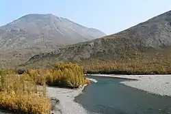
 Panorama of the river | |
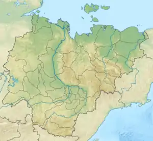
 Mouth location in Yakutia, Russia | |
| Location | |
| Country | Russian Federation |
| Physical characteristics | |
| Source | Suntar-Khayata |
| • coordinates | 62°56′10″N 139°14′04″E |
| Mouth | Aldan River |
• coordinates | 62°31′41″N 135°36′27″E |
• elevation | 115 m (377 ft) |
| Length | 290 km (180 mi) |
| Basin size | 9,950 km2 (3,840 sq mi) |
| Discharge | |
| • average | 27.3 m3/s (960 cu ft/s) |
| Basin features | |
| Progression | Aldan→ Lena→ Laptev Sea |
Tyoply Klyuch village is located by the banks of the river. The nearest relatively larger inhabited place in the area is Khandyga, to the north of the river's mouth.[2] There is a 389 metres (1,276 ft) long bridge of the R504 Kolyma Highway across the Eastern Khandyga.[2][3]
Course
The Eastern Khandyga has its sources in the western section of the Suntar-Khayata Range.[4][5] The river heads roughly westwards and cuts across the Skalisty Range and the Sette Daban. After the river exits the mountain area it enters a wide floodplain, dividing into many channels and flowing roughly southwestwards. Finally if meets the right bank of the Aldan River a little downstream from the mouth of the Tyry, 467 km (290 mi) from the confluence of the Aldan with the Lena River.[6][4][7][5]
Tributaries
The main tributaries of the Eastern Khandyga are the 113 km (70 mi) long Onyollo (Өнньөлө) and the 94 km (58 mi) long Sakkyryr (Саккырыыр) on the left. The river freezes before mid October and stays frozen until mid May. There are about 300 lakes in the river basin, as well as 30 icings with a total area of 42 km2 (16 sq mi).[5]
Fauna
The slopes of the ranges in the upper reaches of the river provide a habitat for the Siberian Apollo butterfly, endemic to the mountains of the Yana — Kolyma watershed.[8]
See also
References
- "Река P.ВОС.ХАНДЫГА in the State Water Register of Russia". textual.ru (in Russian).
- Google Earth
- В Якутии открылся мост через реку Восточная Хандыга
- 1,000,000 scale Operational Navigation Chart; Sheet D-8
- Nature.ykt
- "P-53_54 Chart (in Russian)". Retrieved 9 September 2021.
- Tyry - Water of Russia
- Bakhaev Yu. Notes on the biology of the Arctic Apollo Parnassius arcticus (Eisner, 1968) in Yakutia (Lepidoptera, Papilionidae). Atalanta, 48 (1-4): 170—173, September 2017. — ISSN 0171-0079