Eastern Land Division
The Eastern Land Division is one of five cadastral divisions of Western Australia, within the eastern parts of the Goldfields-Esperance region and the Pilbara region. Most of its territory is covered by deserts, including the part of the Great Sandy Desert, Gibson Desert and Great Victoria Desert.[1]
Eastern Land Division | |
|---|---|
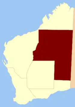 Location within Western Australia prior to 1917 | |
| Coordinates: 24°45′S 125°00′E | |
| Country | |
| State | Western Australia |
| Regions | Goldfields–Esperance Pilbara |
| Land districts | 40 land districts |
History
The Eastern Land Division was created on 2 March 1887, in a reform to the land divisions.[2] On 28 March 1917, the Central Land Division had been incorporated into the Eastern Land Division.[3] The current boundaries of the land enacted on 30 March 1998.[1][4]
Prior to the construction of the Trans-Australian Railway in 1917, the Eastern Land Division, which consists almost entirely of the Great Victoria and Great Sandy Deserts, did not contain any districts.[5]
Subdivisions
The Eastern Land Division is subdivided into 40 land districts.
References
- "LAND ADMINISTRATION ACT 1997 - SCHEDULE 1". Retrieved 1 December 2010.
- "Land Regulations. Part III — Division of the Colony". Western Australia Government Gazette. 2 March 1887. p. 1887:133.
- Land Act Amendment Act 1917 (No. 19), s. 4.
- Land Administration Act 1997. Proclamation. In: Western Australia Government Gazette. 27 March 1998. p. 1998:1765.
- Western Australia. Dept. of Lands and Surveys (1913). South western portion of Western Australia shewing land districts (map), Government Lithographer, Perth.