Edlaston and Wyaston
Edlaston and Wyaston is a civil parish within the Derbyshire Dales district, in the county of Derbyshire, England. The parish includes the villages of Edlaston and Wyaston. In 2011 the parish had a population of 220.[1] It is 120 miles (190 km) north west of London, 11 miles (18 km) north west of the county city of Derby, and 2+1⁄2 miles (4 km) south of the market town of Ashbourne. Edlaston and Wyaston touches the parishes of Clifton and Compton, Osmaston, Rodsley, Shirley, Snelston and Yeaveley.[2] There are seven listed buildings in Edlaston and Wyaston.[3]
Edlaston and Wyaston | |
|---|---|
Civil parish | |
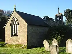
 Saint James Church, Edlaston | |
| Coordinates: 52.980°N 1.727°W | |
| Country | England |
| District | Derbyshire Dales |
| County | Derbyshire |
| Region | East Midlands |
| Status | Parish |
| Main settlements | Edlaston and Wyaston |
| Area | |
| • Total | 2.15 sq mi (556.44 ha) |
| Population (2011)[1] | |
| • Total | 220 |
| • Density | 100/sq mi (40/km2) |
Toponymy
Edlaston: Appears to derive from 'Eadwulf's farm'. This was reported in Domesday as Dulvestune, before a recognisable modern form appearing in public records from the 12th century.[4]
Wyaston: Also in Domesday, as Widerdestune, meaning 'Wīgh(e)ard's farm'.[5]
Edlaston and Wyaston, as an ecclesiastical and subsequent political entity, the two settlements have been combined as a parish since medieval times.[6]
Geography
Location
Edlaston and Wyaston is surrounded by the following local areas:
- Clifton to the north
- Hales Green, Rodsley and Yeavesley to the south
- Osmaston and Shirley to the east
- Snelston to the west.
The parish is roughly bounded by Dobbinhorse Lane along the north, the A515 road to the west, Darley Moor Sports Centre and Brown's Brook along the south, and Poor Plantation and Wyaston Brook to the east.
Settlements
The two settlements within the parish are:
- Edlaston
- Wyaston
Edlaston
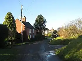
The smaller of the two areas, it is sited centrally within the parish, east of the A515 road, with nearly all properties aligned along Edlaston Lane. The village supports a church and public house. Edlaston Hall is a farmhouse also within the village.
Wyaston

This is 1⁄4 mile (1⁄2 km) southeast of Edlaston, It is aligned to a number of roads including the Ashbourne to Tutbury route, and maintains more residences than Edlaston, as well as the village hall.
Landscape
Primarily farmland throughout the parish outside the villages, there is some small forestry plots throughout the parish, with a stretch surrounding Wyaston Brook. There is a plateau which currently is used for cycle and bike racing.
Water features
Two streams exist by the boundary of the parish: Brown's Brook along the south, and Wyaston Brook to the east.
Land elevation
The parish contains some of the highest land locally, ranging from 120–180 metres (390–590 ft), the parish peak is by the central road junction in Wyaston.
History
Edlaston and Wyaston was an ancient parish in Derby county and became a modern civil parish when those were established in 1866, but only becoming a secular body in 1894.
Edlaston and Wyaston have a long history as separate townships, yet they form a single, if dispersed village.[6]
Edlaston
Wyaston
Industry
As well as the regularised agricultural roles because of its rural location, primarily for dairy farming,[7] the area has also supported much gravel mining for many centuries, with several pits previously recorded in the vicinity. In the mid 1950s, maps showed a water treatment plant and a reservoir in the west of the parish.
Religious sites
St James' Church, Edlaston
The church dates from the 14th century, but rebuilt in the 17th, based on a year inscribed on a date stone.[6]
Governance and demography
Population
There are 220 residents recorded within the parish for the 2011 census.[1]
Council administration
The settlements Edlaston, Wyaston and their surrounding rural areas are combined as one parish for administrative identity. This is managed at the first level of public administration by Edlaston and Wyaston Parish Council. At district level, the wider area is overseen by Derbyshire Dales district council. Derbyshire County Council provides the highest level strategic services locally.
Community, culture & leisure

A community hall is in use at Wyaston village.
There is one public house at Edlaston.
Cycle route
Route 68 of the National Cycle Network follows the Ashbourne to Tutbury road (Wyaston Road).
Aviation and race track
Darley Moor Airfield is used for some civil aviation activities, but also has a dual use as an occasional motor bike and cycling circuit. Based on the site of a former RAF airfield, it is south of Edlaston with the bulk of the circuit within the parish despite the moor being mainly in Snelston.
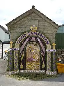
Well dressing
Derbyshire and the wider region has a centuries-old established well dressing ritual, a regular ceremony takes place at a well on Edlaston Lane and in Wyaston village.[9]
Landmarks
Listed buildings
There are seven listed structures in the parish, most including Edlaston Hall are Grade II, with the church at the higher designation of Grade II*.[3]
References
- UK Census (2011). "Local Area Report – (E04002748)". Nomis. Office for National Statistics. Retrieved 1 September 2021.
- "Edlaston and Wyaston". Ordnance Survey. Archived from the original on 8 October 2010.
- "Listed Buildings in Edlaston and Wyaston, Derbyshire Dales, Derbyshire". British Listed Buildings. Archived from the original on 18 May 2021.
- "Edlaston :: Survey of English Place-Names". epns.nottingham.ac.uk. Retrieved 31 August 2021.
- "Wyaston :: Survey of English Place-Names". epns.nottingham.ac.uk. Retrieved 31 August 2021.
- GENUKI. "Genuki: Edlaston and Wyaston, Derbyshire". www.genuki.org.uk. Retrieved 31 August 2021.
- "The Andrews Pages : Edlaston, Derbyshire : Kelly's Directory, 1891". www.andrewsgen.com. Retrieved 1 September 2021.
- "MDR12589 - Wesleyan Methodist Chapel (site of), Edlaston Lane, Wyaston, Edlaston and Wyaston - Derbyshire Historic Environment Record". her.derbyshire.gov.uk. Retrieved 31 August 2021.
- "Derbyshire Well Dressings - Edlaston". www.welldressing.com. Retrieved 1 September 2021.
- Stuff, Good. "Wyaston hlaew, Edlaston and Wyaston, Derbyshire". ancientmonuments.uk. Retrieved 31 August 2021.
- Stuff, Good. "Moated site 60m west of Edlaston Hall, Edlaston and Wyaston, Derbyshire". ancientmonuments.uk. Retrieved 1 September 2021.