Egilsay
Egilsay (/ˈɛɡɪlsiː/, Scots: Egilsay) is one of the Orkney Islands in Scotland, lying east of Rousay. The island is largely farmland and is known for its corncrakes and St Magnus Church, dedicated or re-dedicated to Saint Magnus, who was killed on the island in 1117 by an axe blow to the head. For hundreds of years the story of St. Magnus, part of the Orkneyinga saga, was considered just a legend until a skull with a large crack in it, such as it had been stricken by an axe, was found in the walls of St. Magnus Cathedral in Kirkwall.
| Scottish Gaelic name | ?Eaglais (see meaning) |
|---|---|
| Scots name | Egilsay |
| Old Norse name | Egilsey[1] |
| Meaning of name | Disputed – either Norse "Egil's island" or Norse "ey" + Celtic "eaglais" – "Church island" |
 Egilsay from Rousay with St Magnus Church on the skyline | |
| Location | |
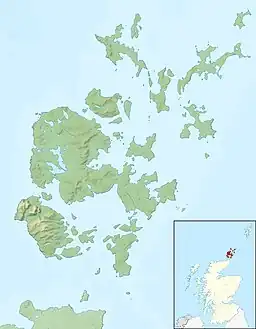
 Egilsay Egilsay shown within Orkney | |
| OS grid reference | HY470301 |
| Coordinates | 59.15°N 2.916°W |
| Physical geography | |
| Island group | Orkney Islands |
| Area | 650 hectares (1,600 acres) |
| Area rank | 67 [2] |
| Highest elevation | 35 m (115 ft) |
| Administration | |
| Sovereign state | United Kingdom |
| Country | Scotland |
| Council area | Orkney |
| Demographics | |
| Population | 26[3] |
| Population rank | 62 [2] |
| Population density | 4/km2 |
| Largest settlement | Skaill |
| References | [4] www.aroundrousay.co.uk/egilsay.shtml |
Etymology
Unusually for the Northern Isles, it has been suggested that Egilsay may have a partly Gaelic name.[1][4] While at first sight, it appears to be Egil's island, "Egil" being a Norse personal name, the Gaelic eaglais (Celtic "eccles") meaning church, may be part of the root, as the island is dominated by a church of pre-Norse foundation. The island of Kili Holm just to the north, may represent cille, a monastic cell.
Present day
The island's population was 26 as recorded by the 2011 census[5] a drop of almost a third since 2001 when there were 37 usual residents.[6] During the same period, Scottish island populations as a whole grew by 4% to 103,702.[7]
Orkney Ferries sail from the island to Tingwall on the Orkney Mainland via Wyre and Rousay.
See also
References
- Anderson, Joseph (ed.) (1873) The Orkneyinga Saga. Translated by Jón A. Hjaltalin & Gilbert Goudie. Edinburgh. Edmonston and Douglas. The Internet Archive. Retrieved 26 August 2013.
- Area and population ranks: there are c. 300 islands over 20 ha in extent and 93 permanently inhabited islands were listed in the 2011 census.
- "National Records of Scotland: Statistical Bulletin" (PDF). 15 August 2013. p. 12. Retrieved 29 January 2022.
- Haswell-Smith, Hamish. (2004) The Scottish Islands. Edinburgh. Canongate.
- National Records of Scotland (15 August 2013). "Appendix 2: Population and households on Scotland's Inhabited Islands" (PDF). Statistical Bulletin: 2011 Census: First Results on Population and Household Estimates for Scotland Release 1C (Part Two) (PDF) (Report). SG/2013/126. Retrieved 14 August 2020.
- General Register Office for Scotland (28 November 2003) Scotland's Census 2001 – Occasional Paper No 10: Statistics for Inhabited Islands. Retrieved 26 February 2012.
- "Scotland's 2011 census: Island living on the rise". BBC News. Retrieved 18 August 2013.
