Etropole Peak
Etropole Peak (Bulgarian: връх Етрополе, romanized: vrah Etropole, IPA: [ˈvrɤx ˈɛtropolɛ]) is a 620m peak in Melnik Ridge, Livingston Island and is named after the town of Etropole in Central Bulgaria.

Location of Livingston Island in the South Shetland Islands.
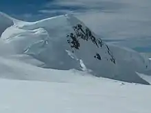
Etropole Peak from Struma Glacier.

Topographic map of Livingston Island, Greenwich, Robert, Snow and Smith Islands.
Maps
- L.L. Ivanov et al. Antarctica: Livingston Island and Greenwich Island, South Shetland Islands. Scale 1:100000 topographic map. Sofia: Antarctic Place-names Commission of Bulgaria, 2005.
- L.L. Ivanov. Antarctica: Livingston Island and Greenwich, Robert, Snow and Smith Islands. Scale 1:120000 topographic map. Troyan: Manfred Wörner Foundation, 2009.
- A. Kamburov and L. Ivanov. Bowles Ridge and Central Tangra Mountains: Livingston Island, Antarctica. Scale 1:25000 map. Sofia: Manfred Wörner Foundation, 2023. ISBN 978-619-90008-6-1
Location
The peak is located at 62°36′07″S 60°08′25″W which is 660 m east of Melnik Peak, 620 m west of Sliven Peak and 1.92 km northwest of Atanasoff Nunatak (Bulgarian mapping in 2005 and 2009 from the Tangra 2004/05 topographic survey).
References
- Etropole Peak. SCAR Composite Antarctic Gazetteer
- Bulgarian Antarctic Gazetteer. Antarctic Place-names Commission. (details in Bulgarian, basic data in English)
External links
- Etropole Peak. Copernix satellite image
This article includes information from the Antarctic Place-names Commission of Bulgaria which is used with permission.
This article is issued from Wikipedia. The text is licensed under Creative Commons - Attribution - Sharealike. Additional terms may apply for the media files.