Fakarava (commune)
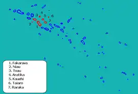
Fakarava is a commune of French Polynesia in the archipelago of the Tuamotu Islands. The commune is in the administrative subdivision of the Îles Tuamotu-Gambier.[1] The commune includes seven islands. The chef-lieu is the village Rotoava.[2]
Fakarava | |
|---|---|
 View of the inner lagoon of Fakarava from Rotoava | |
 Location (in red) within the Tuamotu Archipelago | |
Location of Fakarava | |
| Coordinates: 16°03′40″S 145°37′0″W | |
| Country | France |
| Overseas collectivity | French Polynesia |
| Subdivision | Îles Tuamotu-Gambier |
| Area 1 | 110.0 km2 (42.5 sq mi) |
| Population (2017) | 1,637 |
| • Density | 15/km2 (39/sq mi) |
| Time zone | UTC−10:00 |
| INSEE/Postal code | 98716 / |
| Elevation | 0–0 m (0–0 ft) |
| 1 French Land Register data, which excludes lakes, ponds, glaciers > 1 km2 (0.386 sq mi or 247 acres) and river estuaries. | |
Geography
The commune of Fakarava consists of three associated communes: Fakarava (also including the atoll Toau), Kauehi (also including the atolls Aratika, Raraka and Taiaro) and Niau.[2][3]
| Island | Population 2017[3] | Area (km2) | Area of lagoon (km2) |
|---|---|---|---|
| Fakarava | 830 | 24.1 | 1112 |
| Toau | 14 | 12 | 561 |
| Kauehi | 224 | 16 | 320 |
| Aratika | 225 | 8.3 | 145 |
| Raraka | 96 | 14 | 342 |
| Taiaro | 2 | 16.2 | 16.2 |
| Niau | 246 | 21.0 | 53 |
| TOTAL | 1637 | 110.0 | 2533 |
See also
References
- Décret n° 2005-1611 du 20 décembre 2005 pris pour l'application du statut d'autonomie de la Polynésie française, Légifrance
- Décret n°72-407 du 17 mai 1972 portant création de communes dans le territoire de la Polynésie française, Légifrance
- Répartition de la population en Polynésie française en 2017 Archived 2021-11-21 at the Wayback Machine, Institut de la statistique de la Polynésie française
This article is issued from Wikipedia. The text is licensed under Creative Commons - Attribution - Sharealike. Additional terms may apply for the media files.