Santander State
1863 Santander State
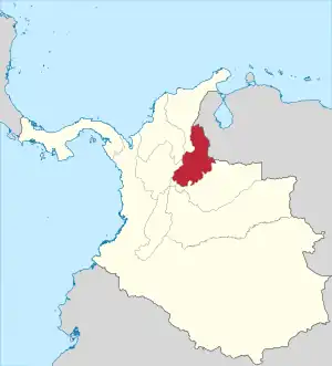
Santander State was one of the states of Colombia. Today the area of the former state makes up most of modern-day areas of the Santander Department and Norte de Santander Department in northeastern Colombia.
Limits
In 1863 it bordered:
- Antioquia State in the West.
- Boyacá State in the South.
- Bolívar State and Magdalena State in the North.
Naming
- 1857-05-13 created as Estado Federal de Santander (Federal State of Santander).
- 1858 recognized as Estado de la Federación in the constitution of the Granadine Confederation,[1]
- 1863 name Estado Soberano (Sovereign State of Santander) in the constitution of the United States of Colombia[2]
Subdivisions
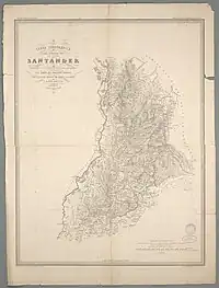
Sovereign State of Santander.
In 1857 the state was divided into the following departamentos:[3]
- Barichara.
- Bucaramanga.
- Charalá.
- Fortul.
- Ocaña.
- Pamplona.
- San Gil.
- Socorro.
- Vélez.
The law of 17 April 1859 divided the state into 7 departamentos:[3]
- Róvira Department (capital Concepción).
- Ocaña Department (capital Ocaña).
- Pamplona Department (capital Pamplona).
- Santander Department (capital San José de Cúcuta).
- Socorro Department (capital Socorro).
- Soto Department (capital Bucaramanga).
In 1860 two more departamentos were created:
References
- Cervantes Virtual: Constitución de la Confederación Granadina de 1858
- Cervantes Virtual: Constitución política de los Estados Unidos de Colombia de 1863
- Geografía Física y Política de la Confederación Granadina: Estado de Santander, Obra dirigida por el General Agustín Codazzi, 2003
This article is issued from Wikipedia. The text is licensed under Creative Commons - Attribution - Sharealike. Additional terms may apply for the media files.