Ferme-Neuve
Ferme-Neuve (French for "New Farm") is a municipality part of the Antoine-Labelle Regional County Municipality, in the Laurentides region of Quebec, Canada. It is the largest incorporated municipality of the Laurentides region.
Ferme-Neuve | |
|---|---|
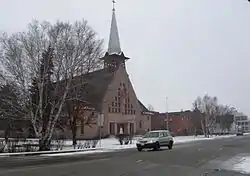 The Roman Catholic church in Ferme-Neuve | |
| Motto: Non nova sed nove (English: "Not new but in a new way") | |
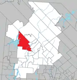 Location within Antoine-Labelle RCM | |
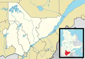 Ferme-Neuve Location in central Quebec | |
| Coordinates: 46°42′N 75°27′W[1] | |
| Country | Canada |
| Province | Quebec |
| Region | Laurentides |
| RCM | Antoine-Labelle |
| Settled | 1890s |
| Constituted | December 24, 1997 |
| Government | |
| • Mayor | Diane Sirard |
| • Federal riding | Laurentides—Labelle |
| • Prov. riding | Labelle |
| Area | |
| • Total | 875.10 km2 (337.88 sq mi) |
| • Land | 790.29 km2 (305.13 sq mi) |
| Population (2021)[3] | |
| • Total | 2,716 |
| • Density | 3.5/km2 (9/sq mi) |
| • Pop. 2016-2021 | |
| • Dwellings | 1,453 |
| Time zone | UTC−5 (EST) |
| • Summer (DST) | UTC−4 (EDT) |
| Postal code(s) | |
| Area code | 819 |
| Highways | |
| Website | www |
The village is located on the shores of the Du Lièvre River and Journalists Lake, and along Quebec Route 309, about 20 kilometres (12 mi) north of Mont-Laurier.
History
In the 19th century, the area began attracting loggers because of its rich red and white pine stands. In 1850, the James MacLaren logging company built a large tree farm called "La Ferme de la Montagne" that was used as a supply camp for loggers. It was sold in 1888 to Cyrille Lafontaine and inhabited by his son Léonard who became the first settler and farmer of Ferme-Neuve.[4] In 1898, the Ferme-Neuve Post Office opened.[1]
In 1902, a group of 8 Montreal journalists, under direction from Lomer Gouin, Minister of Colonization, built a model farm in order to attract more settlers. They also launched a public subscription to build a school. In recognition, the lake adjacent to the settlement was called Lac des Journalistes ("Lake of Journalists").[1]
Also in 1902, the United Township Municipality of Würtele-Moreau-et-Gravel was formed, with Toussaint Cloutier as first mayor. In 1917, the Ferme-Neuve settlement separated from the united township and became an incorporated village, with Henri Berthiaume as its first mayor. In 1930, the United Township Municipality of Würtele-Moreau-et-Gravel changed statutes and was renamed to the Parish Municipality of Ferme-Neuve.[1][4]
On December 24, 1997, both entities were merged again into the new Municipality of Ferme-Neuve.
Demographics
| 2021 | 2016 | |
|---|---|---|
| Population | 2,716 (+0.4% from 2016) | 2,706 (-4.1% from 2011) |
| Land area | 786.19 km2 (303.55 sq mi) | 793.44 km2 (306.35 sq mi) |
| Population density | 3.5/km2 (9.1/sq mi) | 3.4/km2 (8.8/sq mi) |
| Median age | 53.2 (M: 52.4, F: 54.4) | 50.7 (M: 49.8, F: 51.4) |
| Private dwellings | 1,453 (total) 1,276 (occupied) | 1,388 (total) |
| Median household income | $55,600 | $48,480 |
|
| ||||||||||||||||||||||||||||||||||||
| Population amounts prior to 1997 are total of Ferme-Neuve (Village) and Ferme-Neuve (Parish). Source: Statistics Canada | |||||||||||||||||||||||||||||||||||||
Population trend (prior to amalgamation):
- Population in 1996:
- Parish of Ferme-Neuve: 913
- Village of Ferme-Neuve: 2178
- Population in 1991:
- Parish of Ferme-Neuve: 907
- Village of Ferme-Neuve: 2267
Private dwellings occupied by usual residents: 1,276 (total dwellings: 1,453)[3]
Mother tongue:
- English as first language: 0.8%
- French as first language: 98.8%
- English and French as first language: 0%
- Other as first language: 0.4%
Local government
List of former mayors:
- Sylvain Leduc (...–2005)
- Claude Dufour (2005–2009)
- Gilbert Pilote (2009–2021)
- Diane Sirard (2021–present)
See also
References
- "Ferme-Neuve (Municipalité)" (in French). Commission de toponymie du Québec. Retrieved 2009-08-31.
- "Geographic code 79097 in the official Répertoire des municipalités". www.mamh.gouv.qc.ca (in French). Ministère des Affaires municipales et de l'Habitation.
- "Ferme-Neuve, Municipalité (MÉ) Census Profile, 2021 Census of Population". www12.statcan.gc.ca. Government of Canada - Statistics Canada. Retrieved 27 June 2022.
- "Histoire et patrimoine" (in French). Municipalité de Ferme-Neuve. Archived from the original on 2009-02-23. Retrieved 2009-08-31.
- "2021 Community Profiles". 2021 Canadian Census. Statistics Canada. February 4, 2022. Retrieved 2023-10-19.
- "2016 Community Profiles". 2016 Canadian Census. Statistics Canada. August 12, 2021. Retrieved 2022-06-27.
- "2006 Community Profiles". 2006 Canadian Census. Statistics Canada. August 20, 2019.
- "2001 Community Profiles". 2001 Canadian Census. Statistics Canada. July 18, 2021.
External links
![]() Media related to Ferme-Neuve, Quebec at Wikimedia Commons
Media related to Ferme-Neuve, Quebec at Wikimedia Commons
Adjacent Municipal Subdivisions | |
|---|---|
| Cities/towns | |
|---|---|
| Municipalities | |
| Villages | |
| Unorganized territories | |
| |