Flakstadelva
Flakstadelva is a river in Innlandet county, Norway. The 32.6-kilometre (20.3 mi) river begins in the Lavsjømyrene bog areas in northern Løten. From there it runs in a southerly direction and forms the lake Nybusjøen which discharges into the Lundsbekken river. The river flows in a v-shaped valley which twists before its mouth at the town of Hamar where it empties into the lake Mjøsa.[1] The river's erosion has exposed the lower Cambrian and middle Cambrian rock formations in that region.[2]
| Flakstadelva Flagstadelva | |
|---|---|
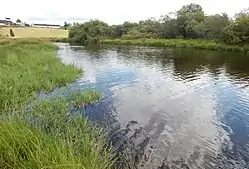 From the delta area near lake Mjøsa | |
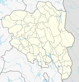 Location of the river  Flakstadelva (Norway) | |
| Location | |
| Country | Norway |
| County | Innlandet |
| Municipalities | Hamar Municipality |
| Physical characteristics | |
| Source | Lavsjømyrene |
| • location | Løten, Norway |
| • coordinates | 61.0059°N 11.2369°E |
| • elevation | 674 metres (2,211 ft) |
| Mouth | Lake Mjøsa |
• location | Hamar, Norway |
• coordinates | 60.7968°N 11.1037°E |
• elevation | 123 metres (404 ft) |
| Length | 32.6 km (20.3 mi) |
| Basin size | 179.88 km2 (69.45 sq mi) |
| Discharge | |
| • average | 1.96 m3/s (69 cu ft/s) |
See also
References
- Puschmann, Oskar (December 1998). "The Norwegian landscape reference system - use of different sources as a base to describe landscape regions" (PDF). Inger Marie Larsen and Isobel Harrison (trans.). Norwegian Institute of Land Inventory. p. Appendix 1.
- Håvard, Guatneb; Ola.M., Sæther (2009). "A compilation ofpreviously published geochemical data on the lower Cambro-Silurian sedimentary sequence, including the alum shales in the Oslo region" (PDF). Geological Survey of Norway. p. 9. ISSN 0800-3416.
This article is issued from Wikipedia. The text is licensed under Creative Commons - Attribution - Sharealike. Additional terms may apply for the media files.