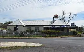
Forest Reefs, New South Wales
Forest Reefs is a village and its surrounding rural locality in Blayney Shire, within the Central West region of New South Wales, Australia. It is approximately 18km from Orange. In 2021, the village and locality had a population of 537.[1]
| Forest Reefs New South Wales | |
|---|---|
 Forest Reefs Tavern | |
 Forest Reefs | |
| Coordinates | 33°27′17.2″S 149°05′10.5″E |
| Population | 537 (2021 census) |
| Postcode(s) | 2798 |
| Location | |
| LGA(s) | Blayney Shire |
| County | Bathurst County |
| State electorate(s) | Bathurst |
| Federal division(s) | Calare |
History
The area now known as Forest Reefs lies within the traditional lands of Wiradjuri people.[2]
The area was known as The Forest or Beneree, at the time of the Robertson Land Act, in 1860. Forest Reefs was a gold mining area with alluvial gold being found in the 1860s and 1870s.[3] There was also very significant deep lead gold mining in the area,[4][5] although the material mined from the deep leads needed to be crushed to obtain the gold it contained. Only a few of the reefs in the area were gold-bearing.[6][7][8]
A post office was opened in 1870. In 1901, the Post Office Directory showed its population of 500, with a butcher shop, blacksmith shop, baker, school, two hotels and three stores.[3] A school opened in January 1871 but closed in May the same year.[9] Another school opened in February 1882 and closed in December 1990.[10]
An area that was identified as 'Forest Reefs' was one of the sites suggested for the new national capital and capital territory, but that proposed area lay west of Blayney, north of Carcoar;[11] it does not correspond with the locality now called Forest Reefs.[12] This suggests that in those times, 'Forest Reefs' was taken to mean a far wider area than it does now.
By 1974, the Post Office had closed. One of the hotels, the Forest Reef Tavern, remains open at the village.[13]
References
- "2021 Forest Reefs, Census All persons QuickStats | Australian Bureau of Statistics". www.abs.gov.au. Retrieved 2023-05-14.
- Studies, Australian Institute of Aboriginal and Torres Strait Islander (2022-11-10). "Map of Indigenous Australia". aiatsis.gov.au. Retrieved 2023-05-14.
- "Forest Reefs, NSW | Central New South Wales Museums". www.centralnswmuseums.com.au. 2015-09-24. Retrieved 2023-05-14.
- "Forest Reefs". Mindat.
- "Great Extended Mine, Forest Reefs". Mindat.
- "THE FOREST REEF GOLDFIELD". Sydney Morning Herald. 1882-06-30. p. 6. Retrieved 2023-05-14.
- "The Forest Reefs Gold Field". Australian Town and Country Journal. 1900-04-14. p. 25. Retrieved 2023-05-14.
- "The Forest Reefs Gold Field. II". Australian Town and Country Journal. 1900-04-21. p. 41. Retrieved 2023-05-14.
- "Forest Reefs (1)". nswgovschoolhistory.cese.nsw.gov.au. Retrieved 2023-05-14.
- "Forest Reefs (2)". nswgovschoolhistory.cese.nsw.gov.au. Retrieved 2023-05-14.
- "Sketch map showing proposed Federal Territory and capital site at Forest Reefs [cartographic material] : Parishes of Calvert, Beaufort, Lindsay, Errol, Belubula & Blake, County of Bathurst N.S.W. 1900 / compiled, drawn and printed at the Department of Lands, Sydney N.S.W." trove.nla.gov.au. Retrieved 2023-05-14.
- "Forest Reefs · New South Wales 2798, Australia". Google Maps. Retrieved 2023-05-14.
- Roberts, Mick (2018-06-25). "Road Trip: Forest Reef Tavern". TIME GENTS. Retrieved 2023-05-14.
External links
![]() Media related to Forest Reefs, New South Wales at Wikimedia Commons
Media related to Forest Reefs, New South Wales at Wikimedia Commons