Forsyth, Georgia
Forsyth is a city in and the county seat of Monroe County, Georgia, United States.[5][6] The population was 4,384 at the 2020 census,[2] up from 3,788 in 2010. Forsyth is part of the Macon Metropolitan Statistical Area.
Forsyth, Georgia | |
|---|---|
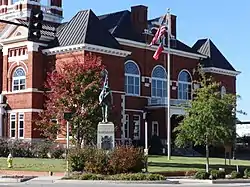 Monroe County Courthouse and Confederate monument in Forsyth | |
| Motto: "What you need when you need it" | |
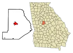 Location in Monroe County and the state of Georgia | |
| Coordinates: 33°2′6″N 83°56′17″W | |
| Country | United States |
| State | Georgia |
| County | Monroe |
| Government | |
| • Mayor | Eric S. Wilson |
| Area | |
| • Total | 5.91 sq mi (15.30 km2) |
| • Land | 5.91 sq mi (15.29 km2) |
| • Water | 0.00 sq mi (0.01 km2) |
| Elevation | 719 ft (219 m) |
| Population | |
| • Total | 4,384 |
| • Density | 742.42/sq mi (286.65/km2) |
| Time zone | UTC-5 (Eastern (EST)) |
| • Summer (DST) | UTC-4 (EDT) |
| ZIP code | 31029 |
| Area code | 478 |
| FIPS code | 13-30732[3] |
| GNIS feature ID | 0331748[4] |
| Website | www |
The Forsyth Commercial Historic District is listed on the National Register of Historic Places and is a tourist attraction. It includes the Monroe County Courthouse and Courthouse Square as well as the surrounding area, including several examples of 19th-century architecture. Forsyth is also home to the Confederate Cemetery, Tift College, and Rum Creek Wildlife Management Area.[6]
History
Forsyth was established in 1823.[7] That same year, the seat of Monroe County was transferred to Forsyth from Johnstonville. Forsyth was named for John Forsyth, governor of Georgia from 1827 to 1829 and Secretary of State under presidents Andrew Jackson and Martin Van Buren.[8]
Geography
Forsyth is located in central Monroe County at 33°02′06″N 83°56′17″W.[9] The city is located along Interstate 75 and U.S. Route 41 northwest of Macon. I-75 runs southeast to northwest through the eastern part of town, with access from exits 185 through 188. The interstate leads southeast 23 miles (37 km) to downtown Macon and northwest 61 miles (98 km) to Atlanta. US 41 runs through the downtown area from east to west, leading southeast to Macon and west 13 miles (21 km) to Barnesville. Other highways that run through the city include Georgia State Routes 18, 42, and 83.
According to the United States Census Bureau, the city of Forsyth has a total area of 9.0 square miles (23 km2), of which 0.004 square miles (2.6 acres), or 0.04%, are water.[1] The city sits atop a ridge which drains southwest to tributaries of Tobesofkee Creek and northeast to tributaries of Rum Creek; both creeks are southeast-flowing tributaries of the Ocmulgee River.
Demographics
| Census | Pop. | Note | %± |
|---|---|---|---|
| 1880 | 1,105 | — | |
| 1890 | 920 | −16.7% | |
| 1900 | 1,172 | 27.4% | |
| 1910 | 2,203 | 88.0% | |
| 1920 | 2,241 | 1.7% | |
| 1930 | 2,277 | 1.6% | |
| 1940 | 2,372 | 4.2% | |
| 1950 | 3,125 | 31.7% | |
| 1960 | 3,697 | 18.3% | |
| 1970 | 3,736 | 1.1% | |
| 1980 | 4,624 | 23.8% | |
| 1990 | 4,268 | −7.7% | |
| 2000 | 3,776 | −11.5% | |
| 2010 | 3,788 | 0.3% | |
| 2020 | 4,384 | 15.7% | |
| U.S. Decennial Census[10] | |||
2020 census
| Race | Num. | Perc. |
|---|---|---|
| White (non-Hispanic) | 1,914 | 43.66% |
| Black or African American (non-Hispanic) | 2,144 | 48.91% |
| Native American | 3 | 0.07% |
| Asian | 50 | 1.14% |
| Other/Mixed | 157 | 3.58% |
| Hispanic or Latino | 116 | 2.65% |
As of the 2020 United States census, there were 4,384 people, 1,687 households, and 883 families residing in the city.
2000 census
As of the census[3] of 2000, there were 3,776 people, 1,457 households, and 1,027 families residing in the city. The population density was 758.8 inhabitants per square mile (293.0/km2). There were 1,560 housing units at an average density of 313.5 per square mile (121.0/km2). The racial makeup of the city was 40.3% White, 57.6% African American, 0.7% Native American, and 0.90% from two or more races. Hispanic or Latino of any race were 1.6% of the population.
There were 1,457 households, out of which 30.7% had children under the age of 18 living with them, 39.5% were married couples living together, 26.4% had a female householder with no husband present, and 29.5% were non-families. 26.3% of all households were made up of individuals, and 13.5% had someone living alone who was 65 years of age or older. The average household size was 2.57 and the average family size was 3.10.
In the city, the population was spread out, with 26.6% under the age of 18, 8.3% from 18 to 24, 28.2% from 25 to 44, 22.8% from 45 to 64, and 14.2% who were 65 years of age or older. The median age was 36 years. For every 100 females, there were 82.2 males. For every 100 females age 18 and over, there were 74.8 males.
The median income for a household in the city was $30,523, and the median income for a family was $35,405. Males had a median income of $25,600 versus $17,536 for females. The per capita income for the city was $19,097. About 14.9% of families and 18.5% of the population were below the poverty line, including 29.1% of those under age 18 and 11.5% of those age 65 or over.
Government
The Georgia Department of Corrections has moved into the former Tift College site in 2010.[12][13] Burruss Correctional Training Center is located in Forsyth next to the Georgia Public Safety Training Center.[14]
Forsyth's first African American mayor, John Howard, served from 2011 to 2015. City Councilman Eric Wilson became mayor in 2015.[15]
Monroe County School District
The Monroe County School District holds pre-school to grade twelve, and consists of three elementary schools, two middle schools, and a high school.[16] The district has 225 full-time teachers and over 3,872 students.[17]
- Samuel E. Hubbard Elementary School
- Katherine B. Sutton Elementary School
- T.G. Scott Elementary School
- Banks Stephens Middle School
- William M. Hubbard Middle School
- Mary Persons High School
Higher education
- Tift College was located in Forsyth.
Notable people
- Harold G. Clarke, jurist and legislator
- 7 Little Johnstons, reality TV personality family
- Eugene Talmadge, 67th governor of Georgia 1933–1937, 1941-1943
References
- "2022 U.S. Gazetteer Files: Georgia". United States Census Bureau. Retrieved January 27, 2023.
- "P1. Race – Forsyth city, Georgia: 2020 DEC Redistricting Data (PL 94-171)". U.S. Census Bureau. Retrieved January 27, 2023.
- "U.S. Census website". United States Census Bureau. Retrieved January 31, 2008.
- "US Board on Geographic Names". United States Geological Survey. October 25, 2007. Retrieved January 31, 2008.
- "Find a County". National Association of Counties. Archived from the original on May 31, 2011. Retrieved June 7, 2011.
- Forsyth Georgia.gov
- Krakow, Kenneth K. (1975). Georgia Place-Names: Their History and Origins (PDF). Macon, GA: Winship Press. p. 80. ISBN 0-915430-00-2.
- Hellmann, Paul T. (May 13, 2013). Historical Gazetteer of the United States. Routledge. p. 230. ISBN 978-1135948597. Retrieved November 30, 2013.
- "US Gazetteer files: 2010, 2000, and 1990". United States Census Bureau. February 12, 2011. Retrieved April 23, 2011.
- "Census of Population and Housing". Census.gov. Retrieved June 4, 2015.
- "Explore Census Data". data.census.gov. Retrieved December 10, 2021.
- Morgan, Carly. Forsyth Prepares for Dept. of Corrections Arrival. WMAZ. November 2009. Retrieved on December 7, 2009.
- GDOC. "|| Georgia Department of Corrections || - Tift College Relocation". Archived from the original on January 28, 2012. Retrieved January 5, 2012..
- Burris Correctional Training Center Archived 2012-04-19 at the Wayback Machine
- McCrummen, Stephanie (October 7, 2018). "'We are here!' From a blue dot in a sea of red comes a hopeful pitch for a politician's visit". Washington Post. Retrieved October 8, 2018.
- Georgia Board of Education, Retrieved June 24, 2010.
- School Stats, Retrieved June 24, 2010.
External links
Municipalities and communities of Monroe County, Georgia, United States | ||
|---|---|---|
| Cities | 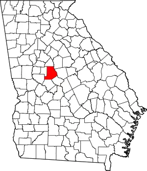 Map of Georgia highlighting Monroe County | |
| CDPs | ||
| Other unincorporated communities | ||
| Ghost town | ||
| Principal cities |  | |
|---|---|---|
| Municipalities | ||
| Other communities | ||
| Counties | ||
| CSA components | ||