Fort Crevecoeur
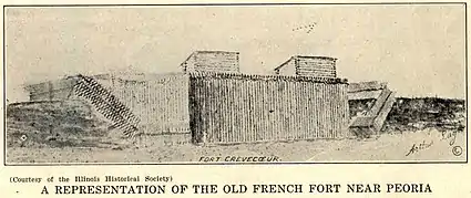
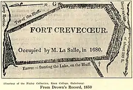
Fort Crevecoeur (French: Fort Crèvecœur) was the first public building erected by Europeans within the boundaries of the modern state of Illinois and the first fort built in the West by the French.[1] It was founded on the east bank of the Illinois River, in the Illinois Country near the present site of Creve Coeur, a suburb of Peoria, Illinois, in January 1680. It was destroyed on April 16, 1680 by members of La Salle's expedition, who mutinied and abandoned it, fearful of being attacked by the Iroquois League as the Beaver Wars extended into the area.[2]
| Fort Crevecoeur | |
|---|---|
| Native name Fr: Fort Crèvecœur | |
 | |
| Location | present-day Creve Coeur, Illinois |
| Built | 1680 |
| Rebuilt | Destroyed in 1680 and replaced by Fort Pimiteoui in 1691 |


Reestablishing a more lasting presence, the French founded Fort St Louis du Pimiteoui nearby in 1691, at the former Kaskaskia village destroyed by the Iroquois (Pimiteoui being the French name for what is now called Peoria Lake, a noted widening in the Illinois River). It became a center of trade and was partially settled during the colonial period. Henri de Tonti was a primary founder of both the Crevecouer and Pimiteoui posts.[3]
Founding
On January 15, 1680, French explorers René-Robert Cavelier, Sieur de La Salle, and Henri de Tonti began construction of a stockade they would call Fort Crèvecoeur (Broken Heart).[2][4][5] It was intended to help the local Peoria tribe defend themselves against the powerful Iroquois league, who had entered this region to secure hunting grounds for the beaver fur trade.[6] On that day in January, Mass was celebrated and the Gospel preached by the Récollets, Gabriel Ribourde, Zenobius Membre, and Louis Hennepin.[7] They finished the fort in early March, naming it "Fort Broken Heart" because of the difficulties, including desertions of troops, that they suffered during its construction.
Dr. Daniel Coxe wrote in 1719:
Monsieur LaSalle erected a fort in the year 1680, which he named Crève-coeur, from the Grief which seiz'd him on the Loss of one of his chief trading Barks richly laden, and the Mutiny and villianous [sic] Intrigues of some of his Company, who first attempted to poyson and afterwards desert him.[8]
La Salle also started building a 40-ton barque to replace Le Griffon, which had disappeared several months before.[9] On March 1, 1680, La Salle set off on foot for Fort Frontenac for supplies (including rigging for the ship),[1] leaving Henri de Tonti to hold Fort Crèvecoeur in Illinois.[10]
Disputed Location
In 2022 appeared articles disputing the location of Fort Crevecoeur, placing it south of Beardstown.[11][12] These build on work cited in 2006.[13]
Destruction
While on his return trip up the Illinois River, La Salle concluded that Starved Rock might provide an ideal location for another fortification and sent word downriver to Tonti regarding this idea. Following La Salle’s instructions, Henri de Tonti had left Fort Crèvecoeur on April 15, 1680 with Father Ribourde and two other men, to begin fortifying the settlement and Fort St. Louis at Starved Rock.[2]
The next day, the remaining seven men, led by Martin Chartier,[14] pillaged Fort Crèvecoeur of all provisions and ammunition, destroyed the fort, and headed back to Canada.[2] On visiting the ruins of the fort a few days later, La Salle observed that someone had written on the side of the unfinished barque, "Nous sommes tous sauvages," ["We are all savages"].[15]: 217
The mutiny was probably caused by the men's fear of being killed by Iroquois raiding parties. They had invaded the region from their stronghold south of the Great Lakes, and were disrupting and attacking the local Illinois communities at the height of the Beaver Wars. The men had demanded that La Salle return with them to Canada, which he was unwilling to do.[9]
In addition, one of the mutineers, shipbuilder Moyse Hillaret who was later captured, testified that "some [of the men] had had no pay for three years," and alleged that La Salle had mistreated them.[16][17] In a deposition made before the Sieur du Chesneau, Intendant of New France, dated 17 August 1680, Hillaret stated the mutineers were dissatisfied "because the said Sieur de La Salle wanted them to build sleighs to draw his goods and personal effects as far as the village of the Illinois [the site of the proposed Fort St. Louis (Starved Rock)]."[17]
Joining Tonti at Starved Rock, two men who had been at Fort Crèvecoeur told him of its destruction. Tonti sent messengers to La Salle in Canada to report the events. Tonti returned to Fort Crèvecoeur to collect any tools not destroyed[2] and moved them to the Kaskaskia Village of the Illinois near Starved Rock. The mutineers, assisted by some other men they recruited along the way, looted some of La Salle's possessions at Michilimackinac and at Fort Niagara. They split into two groups, one of which went to Albany and the second to Fort Frontenac, reportedly with the intention of finding and killing La Salle.[2] In August, La Salle recaptured some of the mutineers, however Chartier took refuge with a band of Shawnee Indians and went with them to Pennsylvania.[14]
On September 10, 1680, nearly six hundred Iroquois warriors, armed with guns, approached the Kaskaskia village.[2] Meeting de Tonti met with the parties in advance, representatives of both the Iroquois League and the Illinois Confederation accused him of treachery.[2] Tonti tried to mediate their disagreements and delay the Iroquois attack until the women, children and old people could escape from the village. Tonti was wounded by an Iroquois warrior, who stabbed him with a knife.[2] The Iroquois burned Kaskaskia village and built a fort on that site near Starved Rock. Tonti with his allies fled the area, heading for La Baye.[2]
Fort St. Louis du Pimiteoui

In 1691, Tonti returned to the area and founded another fort. This fort is known variously as Fort St. Louis du Pimiteoui, Fort Pimiteoui, and Old Fort Peoria (Pimiteoui – English: Fat Lake – was the name of what is now called, Peoria Lake, a stretch where the Illinois River significantly widens).[18][19][5] It was intermittently a center of trade, particularly fur trade, and sometimes settlement throughout the colonial period, when control of it shifted from the French to the British in 1763 after the French and Indian War.[20]
Present-Day Park
| Fort Creve Coeur State Park | |
|---|---|
 | |
| Location | 301 Lawnridge Dr, Creve Coeur, IL 61610 |
| Nearest city | Creve Coeur, Illinois |
| Coordinates | 40°38′47.45″N 89°36′23.92″W |
| Area | 86.6 acres (35.0 ha) |
| Website | https://www.stateparks.com/fort_creve_coeur_state_park_in_illinois.html |
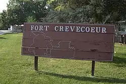
The present-day village of Creve Coeur has a recreation of the fort located in a park in the Creve Coeur Nature Preserve.[21]
The 86.6-acre park was deeded to the village of Creve Coeur in 1976 and leased to the non-profit organization, Fort Crevecoeur, Inc.[22] The non-profit recreated the fort based on original design and dimensions of the 1680 winter quarters.[22][23]
Flora
A small glacial drift hill prairie on the northwestern ridge contains over 50 prairie plant species including little bluestem, Indian grass, pale coneflower, and Canada milk vetch.[22]
Recreation
The park has a museum, gift shop, pavilions, RV park and campground, playground, and hiking and biking trails.[21][24] Five miles of biking trails were cleared by the Peoria Area Mountain Biking Association in 2021.[25] The trail offers views of bluff hardwood woodlands, the Illinois River, and the Peoria skyline.[25]

References
- "The Site of Fort de Crèvecoeur", University of Illinois, 1925.
- "History of Fort Crevecoeur". Fort Crevecoeur Park website. Fort Crevecoeur Inc. 2008-08-30. Retrieved 2009-02-03.
- A., P. M. (1937). "The Oldest Town in Illinois". Journal of the Illinois State Historical Society (1908-1984). 30 (2): 256–260. ISSN 0019-2287.
- Arthur, Robert (1957). "Prologue to the French and Indian War". The Military Engineer. 49 (331): 338–340. ISSN 0026-3982.
- Lessard, Renald; Mathieu, Jacques; Gouger, Lina (1988). "Peuplement Colonisateur Au Pays Des Illinois". Proceedings of the Meeting of the French Colonial Historical Society. 12: 57–68. ISSN 0362-7055.
- "Fort Crèvecoeur, a 1680 French-Peoria Agreement". Retrieved 21 March 2021.
- Jean-Roch Rioux, "Louis Hennepin," Dictionary of Canadian Biography, University of Toronto/Université Laval, 2003
- Daniel Coxe, "A Description of the Great and Famous River Meschacebe or Mississippi, the Rivers increasing it both from the East and West, the Countries adjacent, and the Several Nations of Indians inhabiting therein," in A description of the English province of Carolana, by the Spaniards call'd Florida, and by the French La Louisiane, 1722 ed. published by B. Cowse, London.
- Francis Parkman, "La Salle And The Discovery Of The Great West," American Heritage, April 1957, Volume 8, Issue 3.
- "La Salle," New International Encyclopedia, Volume 13, Second Edition, Dodd, Mead, 1915; p. 581.
- Shelley, Tim. "New research suggests French explorer La Salle's Ft. Crevecoeur's true locale was in Beardstown". WCBU. Retrieved November 30, 2022.
- Gross, Richard. "Native Villages of La Salle's Illinois Country". Journal of the Illinois State Historical Society. 115 (Spring 2022): 33–65.
- "Creve Coeur Location Questioned". Tri States Public Radio. Retrieved November 30, 2022.
- Charles Augustus Hanna, The Wilderness Trail: Or, The Ventures and Adventures of the Pennsylvania Traders on the Allegheny Path, Volume 1, Putnam's sons, 1911
- Parkman, Francis, La Salle and the discovery of the great West: Part III, France and England in North America, Boston: Little, Brown, and company, 1897
- Harriette Simpson Arnow, Seedtime on the Cumberland, Michigan State University Press. (2013)
- "Déclaration faite par devant le Sr. Duchesneau, Intendant en Canada, par Moyse Hillaret, charpentier de barque cy-devant au service du Sr. de la Salle, Aoust, 1680." cited in Francis Parkman, La Salle and the Discovery of the Great West: France and England in North America. Part Third, vol. V-VI; Little, Brown, 1897.
- "Stephen H. Long's Plan for New Fort at Peoria". Journal of the Illinois State Historical Society (1908-1984). 47 (4): 417–421. 1954. ISSN 0019-2287.
- Mulkey, Floyd (1944). "Fort St. Louis at Peoria". Journal of the Illinois State Historical Society (1908-1984). 37 (4): 301–316. ISSN 0019-2287.
- On, Best Books (1939). Illinois; a Descriptive and Historical Guide, - Best Books on, Federal Writers' Project - Google Books. p. 359. ISBN 9781623760120. Retrieved 2014-07-16.
- "Fort Creve Coeure Park". Village of Creve Coeur. Retrieved 2023-10-08.
- "Fort Crevecoeur Park". Illinois River Road. Retrieved 2023-10-08.
- "Fort Creve Coeur". Discover Peoria, IL. Retrieved 2023-10-08.
- "Fort Creve Coeur Park & Nature Preserve (Creve Coeur)". LOCAL OPAL. Retrieved 2023-10-08.
- Shelley, Tim (2021-09-22). "New Hiking And Biking Trail Planned For Creve Coeur". WCBU Peoria. Retrieved 2023-10-08.
Further reading
- Ross, Ryan A. "The Controversy over the Location of Fort Crèvecoeur, 1846-1923," Journal of Illinois History 14:4 (Winter 2011), pp. 277–92.
