Franklin, Georgia
Franklin is a city in Heard County, Georgia, United States. The population was 993 at the 2010 census,[4] up from 902 at the 2000 census. Franklin is the county seat of Heard County.[5] The city is named after Benjamin Franklin.[6]
Franklin, Georgia | |
|---|---|
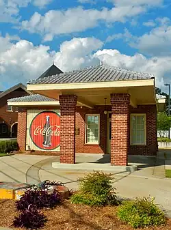 The old Heard County gas station was built in 1938 and features a vintage, hand-painted Coca-Cola advertisement. | |
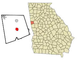 Location in Heard County and the state of Georgia | |
| Coordinates: 33°16′47″N 85°5′54″W | |
| Country | United States |
| State | Georgia |
| County | Heard |
| Named for | Benjamin Franklin |
| Government | |
| • Mayor | Joel Rogers |
| Area | |
| • Total | 3.35 sq mi (8.68 km2) |
| • Land | 3.21 sq mi (8.31 km2) |
| • Water | 0.14 sq mi (0.36 km2) |
| Elevation | 663 ft (202 m) |
| Population (2020) | |
| • Total | 950 |
| • Density | 295.95/sq mi (114.26/km2) |
| Time zone | UTC-5 (Eastern (EST)) |
| • Summer (DST) | UTC-4 (EDT) |
| ZIP code | 30217 |
| Area code | 706 |
| FIPS code | 13-31292[2] |
| GNIS feature ID | 0314347[3] |
| Website | www |
History
Franklin was settled in 1770, and was designated seat of the newly formed Heard County in 1831.[7] The town was hit by a tornado just before midnight on March 25, 2021, with multiple areas in downtown being heavily damaged with the most severe damage being rated high-end EF2. The tornado later became violent and hit nearby Newnan, Georgia to the east at EF4 strength, indirectly killing one person.[8][9]
Geography
Franklin is located in central Heard County at 33°16′47″N 85°05′54″W,[10] along the Chattahoochee River. U.S. Route 27 passes through the east side of the city on a bypass, leading north 23 miles (37 km) to Carrollton and south 19 miles (31 km) to LaGrange. Georgia State Route 34 passes through the center of Franklin, leading northeast 20 miles (32 km) to Newnan and southwest 12 miles (19 km) to the Alabama border. Georgia State Route 100 joins SR 34 for part of its path through Franklin, but leads northwest 14 miles (23 km) to Ephesus and southeast 14 miles to Hogansville.
According to the United States Census Bureau, Franklin has a total area of 3.5 square miles (9.0 km2), of which 3.4 square miles (8.7 km2) are land and 0.2 square miles (0.4 km2), or 4.00%, are water.[4]
Demographics
| Census | Pop. | Note | %± |
|---|---|---|---|
| 1880 | 269 | — | |
| 1890 | 250 | −7.1% | |
| 1900 | 218 | −12.8% | |
| 1910 | 340 | 56.0% | |
| 1920 | 317 | −6.8% | |
| 1930 | 312 | −1.6% | |
| 1940 | 390 | 25.0% | |
| 1950 | 425 | 9.0% | |
| 1960 | 603 | 41.9% | |
| 1970 | 749 | 24.2% | |
| 1980 | 711 | −5.1% | |
| 1990 | 876 | 23.2% | |
| 2000 | 902 | 3.0% | |
| 2010 | 993 | 10.1% | |
| 2020 | 950 | −4.3% | |
| U.S. Decennial Census[11] | |||
2000 census
As of the census[2] of 2000, there were 902 people, 349 households, and 203 families residing in the city. The population density was 277.8 inhabitants per square mile (107.3/km2). There were 398 housing units at an average density of 122.6 per square mile (47.3/km2). The racial makeup of the city was 69.07% White, 29.93% African American, 0.11% Native American, 0.33% from other races, and 0.55% from two or more races. Hispanic or Latino of any race were 1.11% of the population.
There were 349 households, out of which 31.8% had children under the age of 18 living with them, 30.1% were married couples living together, 25.2% had a female householder with no husband present, and 41.8% were non-families. 37.8% of all households were made up of individuals, and 22.6% had someone living alone who was 65 years of age or older. The average household size was 2.27 and the average family size was 3.03.
24.7% of the population of Franklin were under the age of 18, 8.1% were from 18 to 24, 24.6% from 25 to 44, 18.4% from 45 to 64, and 24.2% were 65 years of age or older. The median age was 40 years. For every 100 females, there were 77.9 males. For every 100 females age 18 and over, there were 68.9 males.
The median income for a household in the city was $19,125, and the median income for a family was $23,571. Males had a median income of $29,583 versus $20,724 for females. The per capita income for the city was $14,142. About 27.8% of families and 28.3% of the population were below the poverty line, including 33.3% of those under age 18 and 29.4% of those age 65 or over.
2020 census
| Race | Num. | Perc. |
|---|---|---|
| White (non-Hispanic) | 625 | 65.79% |
| Black or African American (non-Hispanic) | 217 | 22.84% |
| Native American | 3 | 0.32% |
| Asian | 20 | 2.11% |
| Other/Mixed | 64 | 6.74% |
| Hispanic or Latino | 21 | 2.21% |
As of the 2020 United States census, there were 950 people, 421 households, and 215 families residing in the city.
Education
Heard County School District
The Heard County School District holds pre-school to grade twelve, and consists of three elementary schools, a middle school, and a high school.[13] The district has 132 full-time teachers and over 2,278 students.[14]
Old Heard County Jail
.JPG.webp)
Pauly Jail Company of Alabama built the jail in 1912 for $7,500, using plans by Manly Jail Works of Dalton, Georgia. It replaced an older jail built in 1880 that had become unfit. The jail housed up to 16 prisoners upstairs. The Heard County Sheriff (there were eight sheriffs from 1912–1964) and his family lived downstairs. In the 1930s, two prisoners cut the window bars and escaped. Death row prisoners were held here, but the jail's gallows were never used. In 1964, a new county jail opened on the Franklin Square and the old jail closed.
The jail was listed on the National Register of Historic Places on January 27, 1981. In 1987 it was completely restored by the Heard County Historical Society. It now serves as a museum and historical center.
Gallery
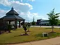 Franklin Court Square
 Franklin City Hall
.JPG.webp) Franklin Post Office (ZIP code: 30217)
Franklin Post Office (ZIP code: 30217).JPG.webp) Heard County Comprehensive High School
Heard County Comprehensive High School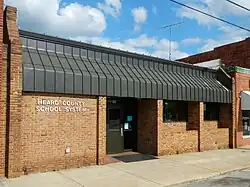 Heard County School System
References
- "2020 U.S. Gazetteer Files". United States Census Bureau. Retrieved December 18, 2021.
- "U.S. Census website". United States Census Bureau. Retrieved January 31, 2008.
- "US Board on Geographic Names". United States Geological Survey. October 25, 2007. Retrieved January 31, 2008.
- "Geographic Identifiers: 2010 Demographic Profile Data (G001): Franklin city, Georgia". American Factfinder. U.S. Census Bureau. Retrieved May 18, 2017.
- "Find a County". National Association of Counties. Archived from the original on May 31, 2011. Retrieved June 7, 2011.
- Gannett, Henry (1905). The Origin of Certain Place Names in the United States. Govt. Print. Off. p. 131.
- Hellmann, Paul T. (May 13, 2013). Historical Gazetteer of the United States. Routledge. p. 230. ISBN 978-1135948597. Retrieved November 30, 2013.
- NWS Damage Survey for March 25-26, 2021 Tornado and Severe Weather Event Update #5 (Report). Iowa Environmental Mesonet. National Weather Service Weather Forecast Office in Peachtree City, Georgia. March 31, 2021. Retrieved March 31, 2021.
- "ArcGIS Web Application". apps.dat.noaa.gov. Retrieved March 26, 2021.
- "US Gazetteer files: 2010, 2000, and 1990". United States Census Bureau. February 12, 2011. Retrieved April 23, 2011.
- "Census of Population and Housing". Census.gov. Retrieved June 4, 2015.
- "Explore Census Data". data.census.gov. Retrieved December 18, 2021.
- Georgia Board of Education . Retrieved June 19, 2010.
- School Stats. Retrieved June 19, 2010.
External links
- Franklin Baptist Church historical marker
- Franklin Methodist Church historical marker
- Heard County Jail historical marker
Municipalities and communities of Heard County, Georgia, United States | ||
|---|---|---|
| Cities | 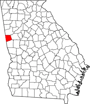 Map of Georgia highlighting Heard County | |
| Town | ||
| CDP | ||
| Other unincorporated communities | ||
| Ghost town | ||
| Footnotes | ‡This populated place also has portions in an adjacent county or counties | |