Franklin, Kansas
Franklin is an unincorporated community in Crawford County, Kansas, United States.[1] As of the 2020 census, the population of the community and nearby areas was 473.[2] Franklin is located along U.S. Route 69, 1 mile (1.6 km) south of Arma, or 5.9 miles (9.5 km) north of Frontenac.
Franklin, Kansas | |
|---|---|
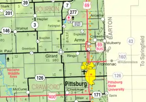 KDOT map of Crawford County (legend) | |
 Franklin  Franklin | |
| Coordinates: 37°31′23″N 94°41′58″W[1] | |
| Country | United States |
| State | Kansas |
| County | Crawford |
| Area | |
| • Total | 1.72 sq mi (4.46 km2) |
| • Land | 1.71 sq mi (4.43 km2) |
| • Water | 0.01 sq mi (0.03 km2) |
| Elevation | 984 ft (300 m) |
| Population | |
| • Total | 473 |
| • Density | 270/sq mi (110/km2) |
| Time zone | UTC-6 (CST) |
| • Summer (DST) | UTC-5 (CDT) |
| ZIP code | 66735 |
| Area code | 620 |
| FIPS code | 20-24325 |
| GNIS ID | 2629157[1] |
| Website | franklinkansas.com |
History
Franklin began as a mining community in the early 1900s. It is located just off Highway 69 Bypass which is a major corridor between Kansas City and Pittsburg, Ks./Joplin, Mo. Franklin was a shipping point on the Joplin & Pittsburg electric railroad.[3] The first post office in Franklin was established in 1908.[4]
On May 4, 2003, a high-end F4 tornado ripped through Franklin, the path reached over 0.5 miles (0.80 km) wide at points. Franklin was all but destroyed, the U.S. Post Office, community center, and approximately 1/3 of family homes were destroyed. Four deaths and approximately 20 injuries were reported.[5][6][7]
Franklin has a post office with ZIP code 66735.[8]
Demographics
| Census | Pop. | Note | %± |
|---|---|---|---|
| 2010 | 375 | — | |
| 2020 | 473 | 26.1% | |
| U.S. Decennial Census | |||
For statistical purposes, the United States Census Bureau has defined Franklin as a census-designated place (CDP).
Area attractions
Miners Hall Museum
Opened on May 1, 2012, the Miner’s Hall Museum was established to preserve and present authentic materials and artifacts that document the history of coal mining and its impact on Southeast Kansas.[9] One exhibit is of the "Amazon Army", a 1921 protest in which thousands of wives, daughters, mothers, sisters and sweethearts of striking coal miners halted work in the mines for three days.[10]
Franklin Sidewalk
Constructed in 1936 with federal funding assistance, the Franklin Sidewalk connects two rural mining communities in Crawford County - Arma and Franklin. The 3-foot wide sidewalk begins at the south edge of Arma and stretches south 1.7 miles to the south edge of Franklin. It has become well known as the "longest sidewalk connecting two communities". It runs adjacent to Business 69 Highway also known as "Jefferson Highway" and the "Frontier Military Scenic Byway". The Franklin Sidewalk appeared in the Guinness Book of World Records in the 1950s or 1960s. It was listed on the National Register of Historic Places by the United States Department of the Interior March 16, 2007 and on the Kansas Register of Historic Places November 18, 2006. [11]
Notable people
- Frank Wayenberg, baseball player
References
- U.S. Geological Survey Geographic Names Information System: Franklin, Kansas
- "Profile of Franklin, Kansas (CDP) in 2020". United States Census Bureau. Archived from the original on November 18, 2021. Retrieved November 17, 2021.
- Blackmar, Frank Wilson (1912). Kansas: A Cyclopedia of State History, Embracing Events, Institutions, Industries, Counties, Cities, Towns, Prominent Persons, Etc. Standard Publishing Company. pp. 679.
- "Kansas Post Offices, 1828-1961 (archived)". Kansas Historical Society. Archived from the original on October 9, 2013. Retrieved 6 June 2014.
- Franklin 2003 tornado stories.
- Tornado damage leaves town on brink of non-existence; Chicago Tribune; June 22, 2003.
- Public Response to Tornado Warnings: A Comparative Study of the May 4, 2003, Tornados in Kansas, Missouri, Tennessee; University of Colorado - Boulder; November 2003.
- ZIP Code Lookup
- "Miners Hall Museum". Miners Hall Museum. Retrieved 13 June 2018.
- "An Army of Amazons". An Army of Amazons. Retrieved 13 June 2018.
- "Sidewalk - Guinness World Record Holder & Road Projects". The Spirit of Franklin Remains. Retrieved 13 June 2018.
Further reading
External links
- Community of Franklin
- USD 246, local school district
- Crawford County maps: Current, Historic, KDOT
Municipalities and communities of Crawford County, Kansas, United States | ||
|---|---|---|
| Cities |  Map of Kansas highlighting Crawford County | |
| Unincorporated communities | ||
| Townships | ||
| Footnotes | †This community is designated a Census-Designated Place (CDP) by the United States Census Bureau. ‡This community also has portions in an adjacent county or counties. | |