Freiberger Mulde
The Freiberger Mulde (also called the Östliche Mulde or Eastern Mulde; Czech: Freiberská Mulda) is the right-hand, 124-kilometre-long (77 mi) headstream of the river Mulde, whose catchment covers an area of 2,981 km2 (1,151 sq mi) in the Czech Republic and Germany in central Saxony. It has a volumetric flow of 35.3 m3/s (1,250 cu ft/s) which is greater than that of the other headstream, the Zwickauer Mulde (or Westliche Mulde or Western Mulde) who flow is about 26.4 m3/s (930 cu ft/s),[2] which is nevertheless the longer stream.
| Freiberger Mulde | |
|---|---|
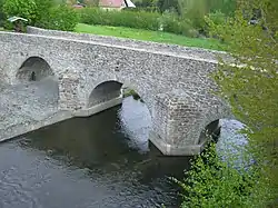
 The Freiberger Mulde and 1501 bridge in Conradsdorf (a district of Halsbrücke) | |
| Location | |
| Countries | |
| Reference no. | DE: 542 |
| Physical characteristics | |
| Source | |
| • location | Moldava, Czech Republic |
| • coordinates | 50°42′26″N 13°40′18″E |
| • elevation | ca. 850 m above sea level (NHN) |
| Mouth | |
• location | Near Sermuth (a district of Colditz) (confluence with the Zwickauer Mulde) |
• coordinates | 51°09′37″N 12°47′53″E |
• elevation | 132.4 m above sea level (NHN) |
| Length | 124 km (77 mi) |
| Basin size | 2,981 km2 (1,151 sq mi)[1] |
| Basin features | |
| Progression | Mulde→ Elbe→ North Sea |
| Landmarks | |
| Tributaries | |
| • left | Münzbach, Kleinwaltersdorfer Bach, Striegis, Zschopau |
| • right | Gimmlitz, Bobritzsch |
The source of the river is in the Ore Mountains, near Moldava, in the Czech Republic. It runs northwest, crossing the border with Germany after a few km, to Freiberg (hence the name), and further northwest through Nossen, Döbeln and Leisnig. A few km north of Colditz, the Freiberger Mulde is joined by the Zwickauer Mulde to form the Mulde. The Mulde is a tributary of the Elbe.
References
- Report by the independent commission of the Saxon State Government Flood Disaster 2002 (pdf file; 882 kB)
- The average discharge of the Zwickauer Mulde at its mouth is recorded by the values of the Wechselburg 1 gauge (Zwickauer Mulde) and indirectly by the Golzern 1 (Mulde) and Erlln (Freiberger Mulde). For the intermediate catchment below Wechselburg, the drainage flow for the area is recorded from the gauge data and multiplied by the catchment area of the Zwickauer Mulde below the Wechselburg 1 gauge.