Fresno Dome
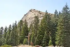
Fresno Dome is a dominant granite dome rising in isolation above the forest of Soquel Meadow in the Sierra National Forest in Madera County, California.
| Fresno Dome | |
|---|---|
 Fresno Dome's northern face as seen from the Fresno Dome trail. | |
| Highest point | |
| Elevation | 7,544 ft (2,299 m) NAVD 88[1] |
| Prominence | 260 ft (79 m)[1] |
| Coordinates | 37°27′16″N 119°32′12″W[2] |
| Geography | |
 Fresno Dome  Fresno Dome | |
| Location | Sierra National Forest, Madera County, California, U.S. |
| Parent range | Sierra Nevada |
| Topo map | USGS White Chief Mountains |
| Geology | |
| Age of rock | Cretaceous |
| Mountain type | Granite dome |
| Climbing | |
| Easiest route | Trail hike (class 1)[3] |
The dome as known to the Mono Indians as "the greeting place" ("wah-me-yelo"). John Muir encountered Fresno Dome, calling it "Wamello", in the 1870s, and used its summit to locate Fresno Grove (now known as Nelder Grove).[4][5]
It is accessible by a trailhead which is a three-mile drive from the Sierra Vista Scenic Byway (part of the National Scenic Byway system).[3] The nearest town is Bass Lake, California, 9.1 miles (14.6 km) to the south.
At its base, sits the Fresno Dome campground, a backwoods campground accessible only by jeep trails. The campground is a favorite spot for deer hunters and is largely empty other than during deer season. The dome offers several technical free climbs rated class 5 or better,[6] with "Guides in a Snowbank" rated at 5.10a.[5]
References
- "Fresno Dome, California". Peakbagger.com.
- "Fresno Dome". Geographic Names Information System. United States Geological Survey, United States Department of the Interior.
- Warszawski, Marek. "Hiking the Fresno Dome". The Fresno Bee. Archived from the original on 2015-08-22. Retrieved 2016-04-12.
- Browning, Peter (1986). Place Names of the Sierra Nevada. Berkeley: Wilderness Press. p. 75. ISBN 0899971199.
- "Fresno Dome (Wamello)". Mountain project, Inc. Retrieved 2014-01-16.
- Roper, Steve (1976). The Climber's Guide to the High Sierra. San Francisco: Sierra Club Books. p. 149. ISBN 978-0871561473.