Friday's Station
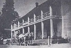
Friday's Station, on US 50 between Kingsbury Grade and Loop Road in Stateline, Nevada, is a two-story wood-frame white building built as a Pony Express station and inn in 1860. In 1986, it was known as Park Cattle Company Residence and was listed on the National Register of Historic Places. The two-story wood-frame white building is visible from U.S. Route 50 near the California-Nevada border at Stateline, Nevada.[2]
Friday's Station | |
 | |
  | |
| Location | US 50 between Kingsbury Grade and Loop Rd., Stateline, Nevada |
|---|---|
| Coordinates | 38°57′50″N 119°56′5″W |
| Area | 7.6 acres (3.1 ha) |
| Built | 1860 |
| NRHP reference No. | 86003259[1] |
| Added to NRHP | October 9, 1986 |
When built, it was also a Union Army military post of the District of California.
During the 1870s through the 1880s it operated as a resort under the name "Buttermilk Bonanza Ranch."[3] The listing included two contributing buildings: the second was a blacksmith shop and stable built in 1850 at the rear of the inn.[1][3]
The nearest locale was called Smalls by 1891,[4] but had changed its name to Tahoe Village by 1955.[5]
The interior of the building has undergone several remodels throughout its history, but the original floor plan included space for both a restaurant and a saloon on the lower floor.[3] The upper floor has remained largely unchanged since its construction, except that it now features bathrooms which were not part of the original structure.[3] It is the only Pony Express station in the state of Nevada to survive in a largely intact form.[3]
It is designated as California Historical Landmark #728.[6]
References
- "National Register Information System". National Register of Historic Places. National Park Service. July 9, 2010.
- "Friday's Station". Waymarking.com. Retrieved November 16, 2010.
- "National Register of Historic Places Inventory/Nomination: Friday's Station / Park Cattle Company Residence". National Park Service. and accompanying three photos
- United States Geological Survey (1891). Markleeville Sheet (JPEG) (Topographic map). 1:125,000. Reston, VA: United States Geological Survey. Retrieved July 17, 2018.
- United States Geological Survey (1957). Bijou, Calif.-Nev (JPEG) (Topographic map). 1:24,000. 7.5 Minute Series. Reston, VA: United States Geological Survey. Retrieved July 17, 2018.
- "Friday's Station". Office of Historic Preservation, California State Parks. Retrieved October 7, 2012.
External links
![]() Media related to Friday's Station at Wikimedia Commons
Media related to Friday's Station at Wikimedia Commons
- Photo from circa 1860-70 of Friday's Station, Valley of Lake Tahoe., Society of California Pioneers Lawrence & Houseworth Photography Albums, 1860–1870 California Views collection, via California Digital Library's Calisphere