Friis Hills
The Friis Hills (77°45′S 161°28′E) are a cluster of ice-free hills, 6 nautical miles (11 km) in extent and rising to 1,750 metres (5,740 ft), on the north side of the bend in Taylor Glacier in Victoria Land, Antarctica. They were named after geographer and archivist Herman Ralph Friis (1906–89), Director of the Center for Polar Archives in the National Archives, a U.S. exchange scientist at the Japanese station East Ongul Island, 1969–70, and a member of the Advisory Committee on Antarctic Names, 1957–73.[1]
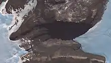
Top: Friis Hills, in their shadow Simmons Lake; bottom (truncated): Solitary Rocks
Although currently "dead and dry, nothing but gravel and sand and boulders" the Friis Hills contain important geological records of the times when Antarctica was much greener.[2][3]
References
- "Friis Hills". Geographic Names Information System. United States Geological Survey, United States Department of the Interior. Retrieved 2012-04-10.
- "The oldest place on Earth". 13 June 2012.
- Chorley, Hannah (3 March 2021). Antarctic ice sheet and climate evolution during the mid-Miocene (thesis). Open Access Victoria University of Wellington. doi:10.26686/wgtn.14150105.v1. S2CID 233772832.
![]() This article incorporates public domain material from "Friis Hills". Geographic Names Information System. United States Geological Survey.
This article incorporates public domain material from "Friis Hills". Geographic Names Information System. United States Geological Survey.