Fulton, Kansas
Fulton is a city in Bourbon County, Kansas, United States.[1] As of the 2020 census, the population of the city was 165.[3]
Fulton, Kansas | |
|---|---|
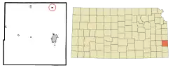 Location within Bourbon County and Kansas | |
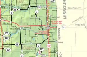 KDOT map of Bourbon County (legend) | |
| Coordinates: 38°0′35″N 94°43′11″W[1] | |
| Country | United States |
| State | Kansas |
| County | Bourbon |
| Founded | 1869 |
| Incorporated | 1884 |
| Named for | Fulton, Illinois |
| Area | |
| • Total | 0.19 sq mi (0.50 km2) |
| • Land | 0.19 sq mi (0.50 km2) |
| • Water | 0.00 sq mi (0.00 km2) |
| Elevation | 846 ft (258 m) |
| Population | |
| • Total | 165 |
| • Density | 870/sq mi (330/km2) |
| Time zone | UTC-6 (CST) |
| • Summer (DST) | UTC-5 (CDT) |
| ZIP code | 66738 |
| Area code | 620 |
| FIPS code | 20-24925 |
| GNIS ID | 2394835[1] |
History
Fulton was originally known as Osaga, and under the latter name was founded in 1869.[4] It was renamed to Fulton in 1878, after the city of Fulton, Illinois.[5][6]
A post office was first established under the name Osaga in 1869.[7]
Geography
Fulton is located along the Little Osage River.
According to the United States Census Bureau, the city has a total area of 0.19 square miles (0.49 km2), all of it land.[8]
Demographics
| Census | Pop. | Note | %± |
|---|---|---|---|
| 1880 | 263 | — | |
| 1890 | 506 | 92.4% | |
| 1900 | 424 | −16.2% | |
| 1910 | 416 | −1.9% | |
| 1920 | 411 | −1.2% | |
| 1930 | 393 | −4.4% | |
| 1940 | 309 | −21.4% | |
| 1950 | 243 | −21.4% | |
| 1960 | 207 | −14.8% | |
| 1970 | 213 | 2.9% | |
| 1980 | 194 | −8.9% | |
| 1990 | 191 | −1.5% | |
| 2000 | 184 | −3.7% | |
| 2010 | 163 | −11.4% | |
| 2020 | 165 | 1.2% | |
| U.S. Decennial Census | |||
2010 census
As of the census[9] of 2010, there were 163 people, 63 households, and 45 families residing in the city. The population density was 857.9 inhabitants per square mile (331.2/km2). There were 84 housing units at an average density of 442.1 per square mile (170.7/km2). The racial makeup of the city was 90.2% White, 0.6% African American, 3.7% Native American, 1.2% from other races, and 4.3% from two or more races. Hispanic or Latino of any race were 5.5% of the population.
There were 63 households, of which 34.9% had children under the age of 18 living with them, 49.2% were married couples living together, 9.5% had a female householder with no husband present, 12.7% had a male householder with no wife present, and 28.6% were non-families. 23.8% of all households were made up of individuals, and 9.5% had someone living alone who was 65 years of age or older. The average household size was 2.59 and the average family size was 3.07.
The median age in the city was 40.5 years. 22.7% of residents were under the age of 18; 12.8% were between the ages of 18 and 24; 19% were from 25 to 44; 31.2% were from 45 to 64; and 14.1% were 65 years of age or older. The gender makeup of the city was 50.9% male and 49.1% female.
2000 census
As of the census[10] of 2000, there were 184 people, 71 households, and 47 families residing in the city. The population density was 975.4 inhabitants per square mile (376.6/km2). There were 87 housing units at an average density of 461.2 per square mile (178.1/km2). The racial makeup of the city was 94.57% White, 3.26% Native American, 0.54% Asian, and 1.63% from two or more races. Hispanic or Latino of any race were 0.54% of the population.
There were 71 households, out of which 32.4% had children under the age of 18 living with them, 52.1% were married couples living together, 8.5% had a female householder with no husband present, and 32.4% were non-families. 28.2% of all households were made up of individuals, and 14.1% had someone living alone who was 65 years of age or older. The average household size was 2.59 and the average family size was 3.08.
In the city, the population was spread out, with 28.8% under the age of 18, 8.2% from 18 to 24, 27.7% from 25 to 44, 22.8% from 45 to 64, and 12.5% who were 65 years of age or older. The median age was 38 years. For every 100 females, there were 104.4 males. For every 100 females age 18 and over, there were 92.6 males.
The median income for a household in the city was $26,094, and the median income for a family was $41,071. Males had a median income of $29,375 versus $25,000 for females. The per capita income for the city was $15,070. About 14.6% of families and 11.8% of the population were below the poverty line, including none of those under the age of eighteen and 16.7% of those 65 or over.
Education
The community is served by Fort Scott USD 234 public school district. It previously operated Fulton High School before it closed.
References
- U.S. Geological Survey Geographic Names Information System: Fulton, Kansas
- "2019 U.S. Gazetteer Files". United States Census Bureau. Retrieved July 24, 2020.
- "Profile of Fulton, Kansas in 2020". United States Census Bureau. Archived from the original on November 8, 2022. Retrieved November 8, 2022.
- Blackmar, Frank Wilson (1912). Kansas: A Cyclopedia of State History, Embracing Events, Institutions, Industries, Counties, Cities, Towns, Prominent Persons, Etc. Standard Publishing Company. pp. 702.
- Gannett, Henry (1905). The Origin of Certain Place Names in the United States. Govt. Print. Off. pp. 133.
- Kansas State Historical Society (1916). Biennial Report of the Board of Directors of the Kansas State Historical Society. Kansas State Printing Plant. pp. 148.
- "Many Towns Have Disappeared". The Fort Scott Tribune. July 16, 1976. pp. 2C. Retrieved May 16, 2015.
- "US Gazetteer files 2010". United States Census Bureau. Archived from the original on July 2, 2012. Retrieved July 6, 2012.
- "U.S. Census website". United States Census Bureau. Retrieved July 6, 2012.
- "U.S. Census website". United States Census Bureau. Retrieved January 31, 2008.
Further reading
External links
Municipalities and communities of Bourbon County, Kansas, United States | ||
|---|---|---|
| Cities | 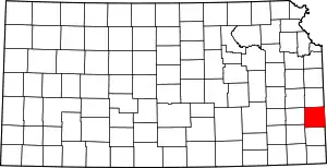 Map of Kansas highlighting Bourbon County | |
| Unincorporated communities | ||
| Townships | ||
| Footnotes | †This community is designated a Census-Designated Place (CDP) by the United States Census Bureau. ‡This community also has portions in an adjacent county or counties. | |