Achada Furna
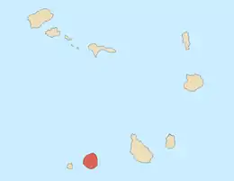
Achada Furna (Portuguese pronunciation: [ɐˈʃaðɐ ˈfuɾnɐ]) is a settlement in the southern part of the island of Fogo, Cape Verde. It is situated 15 km east of the island capital São Filipe. At the 2010 census its population was 495. Its elevation is about 870 meters. Nearby places include Cabeça Fundão to the north, Figueira Pavão to the east, Fonte Aleixo to the south and Monte Largo to the west.
Achada Furna | |
|---|---|
Settlement | |
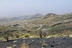
 Panoramic view of the south of the island, on the left is Achada Furna and surrounding it are small hills. | |
 | |
| Coordinates: 14.873°N 24.359°W | |
| Country | Cape Verde |
| Island | Fogo |
| Municipality | Santa Catarina do Fogo |
| Civil parish | Santa Catarina do Fogo |
| Population (2010)[1] | |
| • Total | 495 |
| ID | 83101 |
Climate
Its climate is cooler than the low-lying areas of the island. The average temperature is 18.5 °C (65.3 °F). Average rainfall is 366 millimeters, the highest is 149 mm in September and the lowest is without a single precipitation between the months of March and May.[2]
| Climate data for Achada Furna, 874 metres ASL | |||||||||||||
|---|---|---|---|---|---|---|---|---|---|---|---|---|---|
| Month | Jan | Feb | Mar | Apr | May | Jun | Jul | Aug | Sep | Oct | Nov | Dec | Year |
| Average high °C (°F) | 19.9 (67.8) |
20.0 (68.0) |
20.7 (69.3) |
21.1 (70.0) |
21.6 (70.9) |
22.2 (72.0) |
22.8 (73.0) |
23.2 (73.8) |
23.7 (74.7) |
23.5 (74.3) |
22.7 (72.9) |
20.6 (69.1) |
21.8 (71.3) |
| Daily mean °C (°F) | 16.7 (62.1) |
16.5 (61.7) |
17.1 (62.8) |
17.4 (63.3) |
18.1 (64.6) |
18.7 (65.7) |
19.5 (67.1) |
20.2 (68.4) |
20.6 (69.1) |
20.7 (69.3) |
19.4 (66.9) |
17.8 (64.0) |
18.6 (65.4) |
| Average low °C (°F) | 13.5 (56.3) |
13.1 (55.6) |
13.5 (56.3) |
13.8 (56.8) |
14.7 (58.5) |
15.3 (59.5) |
16.2 (61.2) |
17.2 (63.0) |
17.5 (63.5) |
17.9 (64.2) |
16.2 (61.2) |
15.0 (59.0) |
15.3 (59.6) |
| Average rainfall mm (inches) | 3 (0.1) |
3 (0.1) |
0 (0) |
0 (0) |
0 (0) |
1 (0.0) |
22 (0.9) |
115 (4.5) |
149 (5.9) |
51 (2.0) |
14 (0.6) |
8 (0.3) |
366 (14.4) |
| Source: Climate-Data.ORG[2] | |||||||||||||
References
- "2010 Census results". Instituto Nacional de Estatística Cabo Verde (in Portuguese). 24 November 2016.
- "Weather data for Achada Furna". Climate-Data.org. Retrieved 5 January 2014.
Wikimedia Commons has media related to Achada Furna.
This article is issued from Wikipedia. The text is licensed under Creative Commons - Attribution - Sharealike. Additional terms may apply for the media files.
