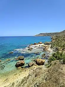
Għajn Barrani
Għajn Barrani (English: Foreigner’s Spring) is a stretch of cliffs located along the north of Gozo, Malta, from Marsalforn to Ramla Bay. The area consists of flat terrain, rocks and clay slopes.[1][2]

It contains a hidden beach due to its secluded position.[3][4]
History
During the Invasion of Gozo in 1551, the Ottoman Turks used to stop with their galleys at Għajn Barrani due to the fresh water arising from its springs.[5] It is assumed that the name Għajn Barrani originates from this event.
Wildlife
Għajn Barrani contains various native trees, including pears, plums, olive trees and grape vines.[6] The clay slopes also have a range of endemic species, including Hyoseris frutescens[7], Matthiola incana[8], Trifolium squamosum, Ononis oligophylla,[9] Juncus acutus,[1] Darniella melitensis[10] and Atriplex halimus.
Protection status
Għajn Barrani is enlisted as a protected area by Natura 2000.[1][11][12]
Gallery
 Passage view of Għajn Barrani
 Flat terrain in Għajn Barrani
 Landscape in Għajn Barrani
See also
References
- "L-Inħawi ta' Għajn Barrani (MT0000001)". Natura 2000. European Environment Agency. Retrieved 2021-04-30.
- "Għajn Barrani". VisitGozo. Retrieved 2021-04-30.
- "5 Hidden Beaches In Gozo To Visit This Summer". Air Malta Blog. 2018-08-05. Retrieved 2021-05-02.
- Collins, Nicola. "The Best Secret Beaches in Malta to Visit". Culture Trip. Retrieved 2021-05-02.
- F. Attard, Anton (2015). "The Lore of Turkish Raids on Gozo" (PDF). University of Malta. Retrieved 2021-04-30.
- "Għajn Barrani (l/o Xagħra)". Times of Malta. Retrieved 2021-05-02.
- "Għajn Barrani area". Times of Malta. Retrieved 2021-05-02.
- "Għajn Barrani area". Times of Malta. Retrieved 2021-05-02.
- Mifsud, Stephen (2002-08-23). "Ononis oligophylla (Few-leaved Restharrow) : MaltaWildPlants.com - the online Flora of the Maltese Islands". www.maltawildplants.com. Retrieved 2021-05-02.
- "BioSnippet Issue 6" (PDF). ERA. 2019. Retrieved 2021-05-02.
- Caruana Dingli, Petra; Galea, Martin (2016). "THE FUTURE OF NATURE PARKS IN MALTA" (PDF). Din l-Art Ħelwa. p. 43. Retrieved 2021-05-02.
- "Tree Protection Areas". ERA. Retrieved 2021-05-02.