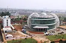
Gading Serpong
Gading Serpong is a township, 21 km west of Jakarta at Kelapa Dua and Pagedangan, Tangerang Regency of Banten province in Indonesia. Total land area of this satellite city is about 1500 hectares, which was being first developed by PT Summarecon Agung as Summarecon Serpong.[1] In 1993, Keris Group in-cooperated with the development and the name was changed as Gading Serpong. Later Paramount Land also joined the project.[2] To accelerate development in 2004, partners of the project decided to develop the Gading Serpong region individually, with a share of approximately equal shares. Now the township is mainly divided into two parts as Summarecon Serpong and Paramount Serpong. The township already has schools, universities and colleges, modern markets, sports and recreation clubs, golf courses and clubs, hotels, convention centres, and hospitals.

Facilities
- Multimedia Nusantara University
- Summarecon Mall Serpong
- Big Ben International Centre for English, Music and the Arts
- Christian School BPK Penabur Gading Serpong
- Pahoa Integrated School
- Tunas Bangsa Christian School
- Salsa Food City
- Sinpasa Modern Market
- The Springs Club
- Summarecon Car Exchange
- Emerald Car Market
- SMP Islam Al-Azhar 41 Summarecon Serpong
- Scientia Convention Center
- Garden Walk & Food Village
- Scientia Square Park
- Summarecon Digital Center
- Gading Raya Padang Golf & Club
- Partner 10
- Plaza Summarecon
- St. Carolus Women And Children's Hospital
- Plaza Summarecon Serpong
- Ibis Hotel
- Atria - Hotel & Conference Center
- Paramount Residences Apartments
- Paramount Skyline Complex
- Bethsaida Hospital
- Hotel Fame Serpong
Transport
Gading Serpong has direct access to Jakarta-Merak Toll Road and Jakarta Outer Ring Road. TransJakarta operates feeder bus routes from the township to different areas of Jakarta.[3] Serpong railway station and the adjacent Rawa Buntu station of Jakarta Commuter Rail is located close to the township.