Shire of Gannawarra
The Shire of Gannawarra is a local government area in Victoria, Australia, located in the northern part of the state. It covers an area of 3,735 square kilometres (1,442 sq mi) and, in August 2021 had a population of 10,683.[3]
| Shire of Gannawarra Victoria | |||||||||||||||
|---|---|---|---|---|---|---|---|---|---|---|---|---|---|---|---|
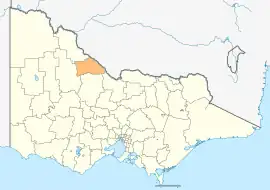 Location in Victoria | |||||||||||||||
| Population | 10,683 (2021)[1] | ||||||||||||||
| • Density | 2.8602/km2 (7.4080/sq mi) | ||||||||||||||
| Established | 1995 | ||||||||||||||
| Gazetted | 20 January 1995[2] | ||||||||||||||
| Area | 3,735 km2 (1,442.1 sq mi)[3] | ||||||||||||||
| Mayor | Cr Charlie Gillingham | ||||||||||||||
| Council seat | Kerang | ||||||||||||||
| Region | Loddon Mallee | ||||||||||||||
| State electorate(s) | Murray Plains | ||||||||||||||
| Federal division(s) | Mallee | ||||||||||||||
| Website | Shire of Gannawarra | ||||||||||||||
| |||||||||||||||
It includes the towns of Cohuna, Kerang, Koondrook, Leitchville and Quambatook. It was formed in 1995 from the amalgamation of the Borough of Kerang and most parts of the Shire of Kerang and Shire of Cohuna.[2]
The Shire is governed and administered by the Gannawarra Shire Council; its seat of local government and administrative centre is located at the council headquarters in Kerang, it also has a service centre located in Cohuna. The Shire is named after a small town, that is Gannawarra, located between Cohuna and Koondrook.
The northeastern border of the shire is the Murray River. The Loddon River flows through the shire, feeding into the Murray. The Gunbower State Forest is a significant source of River Red Gum timber, supplying a historic sawmill in Koondrook. Gunbower Island is the largest inland island in the local area.[4] It is between the Murray River and the Gunbower Creek, an anabranch of the Murray.
The western part of the shire is predominantly used for cereal grain production. The north and east have significant dairying and milk processing. Tourists are attracted to the rivers (for fishing) and also the lakes (for bird watching and water sports).
Council
Current composition
The council is composed of four wards and seven councillors, with three councillors elected to represent the Patchell Ward, two councillors elected to represent the Yarran Ward and one councillor per remaining ward elected to represent each of the other wards. The current council was elected in October 2020.[5]
| Ward | Party | Councillor | Notes | |
|---|---|---|---|---|
| Avoca | Independent | Charlie Gillingham | ||
| Murray | Independent | Ross Stanton | ||
| Patchell | Independent | Kelvin Burt | ||
| Independent | Travis Collier | |||
| Independent | Jane E. Ogden | |||
| Yarran | Independent | Garner Smith | ||
| Independent | Keith Link | |||
Administration and governance
The council meets in the council chambers at the council headquarters in the Kerang Municipal Offices, which is also the location of the council's administrative activities. It also provides customer services at both its administrative centre in Kerang, and its service centre in Cohuna.
Townships and localities
The 2021 census, the shire had a population of 10,683 up from 10,549 in the 2016 census[6]
| Population | ||
|---|---|---|
| Locality | 2016 | 2021 |
| Appin | 11 | 12 |
| Appin South^ | 29 | 38 |
| Bael Bael | 8 | 10 |
| Beauchamp^ | 44 | 44 |
| Benjeroop | 45 | 56 |
| Budgerum East | 5 | 0 |
| Burkes Bridge | 14 | 14 |
| Cannie | 22 | 16 |
| Capels Crossing | 35 | 54 |
| Cohuna | 2,428 | 2,415 |
| Cullen | 39 | 36 |
| Daltons Bridge | 37 | 57 |
| Dingwall | 81 | 99 |
| Fairley | 15 | 14 |
| Population | ||
|---|---|---|
| Locality | 2016 | 2021 |
| Gannawarra | 94 | 110 |
| Gonn Crossing | 56 | 50 |
| Gredgwin^ | 15 | 13 |
| Horfield^ | 91 | 93 |
| Keely | 60 | 57 |
| Kerang | 3,893 | 3,960 |
| Kerang East | 40 | 44 |
| Koondrook | 991 | 1,101 |
| Koroop | 80 | 63 |
| Lake Charm | 168 | 147 |
| Lake Meran^ | 23 | 22 |
| Lalbert | 151 | 138 |
| Leitchville^ | 558 | 576 |
| Population | ||
|---|---|---|
| Locality | 2016 | 2021 |
| Macorna^ | 87 | 67 |
| Macorna North | 20 | 31 |
| McMillans | 93 | 87 |
| Mead | 89 | 102 |
| Meatian^ | 20 | 19 |
| Meering West^ | 13 | 12 |
| Milnes Bridge | 24 | 31 |
| Mincha West | 32 | 16 |
| Murrabit | 201 | 230 |
| Murrabit West | 45 | 41 |
| Myall | 10 | 17 |
| Mystic Park | 181 | 212 |
| Ninyeunook | 11 | 13 |
| Population | ||
|---|---|---|
| Locality | 2016 | 2021 |
| Normanville | 35 | 34 |
| Oakvale | 21 | 19 |
| Pine View | 0 | 4 |
| Quambatook | 249 | 229 |
| Reedy Lake | 26 | 26 |
| Sandhill Lake | 5 | 9 |
| Teal Point | 60 | 54 |
| Tittybong^ | 3 | 3 |
| Towaninny^ | 11 | 4 |
| Tragowel | 104 | 83 |
| Wandella | 69 | 67 |
| Wee Wee Rup | 35 | 31 |
| Westby | 26 | 27 |
^ - Territory divided with another LGA
References
- Australian Bureau of Statistics (28 June 2022). "2021 Community Profiles: Gannawarra (Local Government Area)". 2021 Census of Population and Housing. Retrieved 8 May 2023.
- Victoria Government Gazette – Online Archive (1837–1997). "S4 of 1995: Order estg (Part 6) the Shire of Gannawarra". State Library of Victoria. State Government of Victoria (published 20 January 1995). pp. 3–4. Retrieved 10 January 2014.
- "3218.0 – Regional Population Growth, Australia, 2017-18: Population Estimates by Local Government Area (ASGS 2018), 2017 to 2018". Australian Bureau of Statistics. Australian Bureau of Statistics. 27 March 2019. Retrieved 25 October 2019. Estimated resident population, 30 June 2018.
- "Gannawarra Shire Council - Murray River Region". Gannawarra Shire Council. 13 March 2003. Archived from the original on 29 August 2007. Retrieved 10 June 2007.
- "Gannawarra Shire Council election results 2020". www.vec.vic.gov.au. Retrieved 11 November 2020.
- "Census | Australian Bureau of Statistics". www.abs.gov.au. 11 January 2023.
External links
- Gannawarra Shire Council official website
- Metlink local public transport map
- Link to Land Victoria interactive maps
Localities in the Shire of Gannawarra | ||
|---|---|---|
| Town |  | |
| Locality |
| |
^ - Territory divided with another LGA | ||