Garges-lès-Gonesse
Garges-lès-Gonesse (French pronunciation: [ɡaʁʒ lɛ ɡɔnɛs] ⓘ, literally Garges near Gonesse) is a commune in the Val-d'Oise department in northern France. It is located in the northern suburbs of Paris, 14.1 km (8.8 mi) from the center of Paris. The city is a part of the Paris urban area. It is the seat of the canton of Garges-lès-Gonesse, which also covers Arnouville.
Garges-lès-Gonesse | |
|---|---|
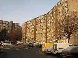 One of the city's projects and major urban concentrations, Les Doucettes. | |
 Coat of arms | |
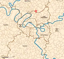 Location (in red) within Paris inner and outer suburbs | |
Location of Garges-lès-Gonesse | |
 Garges-lès-Gonesse  Garges-lès-Gonesse | |
| Coordinates: 48°58′22″N 2°24′03″E | |
| Country | France |
| Region | Île-de-France |
| Department | Val-d'Oise |
| Arrondissement | Sarcelles |
| Canton | Garges-lès-Gonesse |
| Intercommunality | CA Roissy Pays de France |
| Government | |
| • Mayor (2020–2026) | Benoît Jimenez[1] |
| Area 1 | 5.47 km2 (2.11 sq mi) |
| Population | 43,215 |
| • Density | 7,900/km2 (20,000/sq mi) |
| Time zone | UTC+01:00 (CET) |
| • Summer (DST) | UTC+02:00 (CEST) |
| INSEE/Postal code | 95268 /95140 |
| Elevation | 34–80 m (112–262 ft) (avg. 60 m or 200 ft) |
| 1 French Land Register data, which excludes lakes, ponds, glaciers > 1 km2 (0.386 sq mi or 247 acres) and river estuaries. | |
The city is strongly urbanized and is near to Paris–Le Bourget Airport. Garges-lès-Gonesse was transformed from an old rural village to a suburb at the beginning of the 20th century.
Population
|
| ||||||||||||||||||||||||||||||||||||||||||||||||||||||||||||||||||||||||||||||||||||||||||||||||||||||||||||||||||
| Source: EHESS[3] and INSEE (1968-2017)[4] | |||||||||||||||||||||||||||||||||||||||||||||||||||||||||||||||||||||||||||||||||||||||||||||||||||||||||||||||||||
Transport
Garges-lès-Gonesse is served by Garges – Sarcelles station on Paris RER line D.
Education
Primary schools:[5]
- 13 preschools
- 11 elementary schools
- Four combined preschools and elementary schools
Secondary schools:
- Junior high schools: Paul Eluard, Henri Wallon, Pablo Picasso, and Henri Matisse[6]
- Senior high school/sixth-form college: Lycée Simone de Beauvoir[7]
- Vocational high school: Lycée professionel Arthur Rimbaud[8]
Personalities
- Diamory Sylla, basketball player
- Marc Macedot, athlete
- Mr. Brainwash, street artist
References
- "Répertoire national des élus: les maires" (in French). data.gouv.fr, Plateforme ouverte des données publiques françaises. 13 September 2022.
- "Populations légales 2020". The National Institute of Statistics and Economic Studies. 29 December 2022.
- Des villages de Cassini aux communes d'aujourd'hui: Commune data sheet Garges-lès-Gonesse, EHESS (in French).
- Population en historique depuis 1968, INSEE
- "Les écoles à Garges." Garges. Retrieved on September 7, 2016.
- "Les collèges Archived 2016-09-14 at the Wayback Machine." Garges. Retrieved on September 7, 2016.
- "Le lycée." Garges. Retrieved on September 7, 2016.
- "Le lycée professionnel Archived 2020-10-06 at the Wayback Machine." Garges. Retrieved on September 7, 2016.
External links
- Official website (in French)
- Base Mérimée: Search for heritage in the commune, Ministère français de la Culture. (in French)
- Association of Mayors of the Val d'Oise (in French)
Wikimedia Commons has media related to Garges-lès-Gonesse.
This article is issued from Wikipedia. The text is licensed under Creative Commons - Attribution - Sharealike. Additional terms may apply for the media files.