George F. Jenks
George Frederick Jenks (1916–1996) was an American geographer known for his significant contributions to cartography and geographic information systems (GIS).[1] With a career spanning over three decades, Jenks played a vital role in advancing map-making technologies, was instrumental in enhancing the visualization of spatial data, and played foundational roles in developing modern cartographic curricula.[1][2] The Jenks natural breaks optimization, based on his work, is still widely used in the creation of thematic maps, such as choropleth maps.[3][4]
George Frederick Jenks | |
|---|---|
| Born | 16 July 1916 |
| Died | 29 December 1996 (aged 80) |
| Citizenship | United States of America |
| Alma mater | University at Albany, SUNY, Syracuse University |
| Occupation | Geographer |
Education and field
George F. Jenks earned his Ph.D. in geography from Syracuse University in 1950. Their dissertation was titled "New Land Development in the Rice Economy of the Weiner Area, Arkansas."[1] Jenks initially focused their research on agricultural geography, which was the subject of their dissertation and master's thesis. After being exposed to Richard Edes Harrison as a cartography instructor, Jenks began to shift towards researching cartography.[1] This interest led Jenks to become one of the most influential cartographic researchers of the 20th century.[1][5][6]
Career
Military
Jenks joined the United States Army Air Corps in 1941 after graduating with his bachelor's degree.[1] During World War II, he served as an instructor of aerial navigation.[1] The highest rank he held was First lieutenant.[1] Jenk's time as an instructor of aerial navigation inspired him to pursue a career in geography.[1]
Academic
After his time in the military, Jenks went to graduate school at Syracuse University to study geography.[1] After graduating from Syracuse University, Jenks's first position was at the Department of Rural Economics and Sociology at the University of Arkansas.[1] In 1949, Jenks took a position in the Geography Department at the University of Kansas.[1][7][8] Here, Jenks would grow the cartography program within the University of Kansas department of geography into one of the most influential in the country.[1][7] Throughout his career, Jenks advocated for improved curriculums for cartographers and a greater focus on the science of applied mapping.[1][7][2] Jenks retired from the University of Kansas in 1986.[6][8]
While Jenks publications and research were highly influential, he is noted to have focused much of his energy on helping his graduate students.[7][5] These students carried his influence into other geography departments across the United States, shaping how cartographic training is accomplished.[7][5] He continued to work with graduate students at the University of Kansas even after his retirement in 1986.[7]
Publications
Jenks early publications focus on his interest in agricultural geography.[7] After receiving a grant award award from the Fund for the Advancement of Science, Jenks research shifted towards improving cartography, both in terms of map production and training of cartographers.[2][7] This led to decades of publications focused on human error introduced into maps by cartographers, generalization introduced during the mapping process, eye movement, three-dimensional mapping, geostatistics, and thematic mapping in general.[7][9][10][11] As the concept of computer cartography was only introduced in 1959 by Waldo Tobler, Jenks publications were extremely influential in laying the foundation for GIS, thematic mapping, and modern cartography.[12]
Jenks natural breaks optimization method
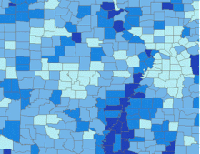
One of the most influential concepts developed by Jenks in terms of applied cartography is the Jenks Natural Breaks optimization method. Jenks made a breakthrough with the development of the "Jenks Natural Breaks Optimization Algorithm," commonly known as the Jenks Natural Breaks Algorithm, in a 1967 paper.[13] This algorithm is widely used in cartography and GIS to classify data into natural groupings, thereby enhancing the visual representation of data on maps.[3][4] The algorithm optimally minimizes the variance within each group and maximizes the variance between groups, resulting in more effective data visualization. It is the default method for dividing classes in thematic maps such as choropleths in Esri software, such as ArcGIS.[4] This method has limitations, and alternative methods for dividing classes include quantiles, standard deviation, and equal interval.[4]
See also
References
- McMaster, Robert (1997). "In Memoriam: George F. Jenks (1916-1996)". Cartography and Geographic Information Systems. 24 (1): 56–59. doi:10.1559/152304097782438764.
- Jenks, George (December 1953). "An Improved Curriculum for Cartographic Training at the College and University Level". Annals of the Association of American Geographers. 43 (2): 317–331. doi:10.2307/2560899.
- "Jenks natural breaks classification method". CDC National Center for Health Statistics. Retrieved 27 July 2023.
- "Data classification methods". ESRI. Retrieved 27 July 2023.
- Gilmartin, Patricia P. (1987). "A SYNOPSIS OF GEORGE F JENKS' CAREER". Cartographica. 24 (2): 128–135. doi:10.3138/L335-R134-53WN-05K2.
- "George F. Jenks map research projects collection". Kenneth Spencer Research Library Archival Collections. Retrieved 27 July 2023.
- McMaster, Robert; McMaster, Susanna (2002). "A History of Twentieth-Century American Academic Cartography". Cartography and Geographic Information Science. 29 (3): 305–321. doi:10.1559/152304002782008486.
- White, Travis M. "Inside Spencer: The KSRL Blog". Kenneth Spencer Research Library. Retrieved 27 July 2023.
- Jenks, George F. (1963). "Generalization in Statistical Mapping". Annals of the Association of American Geographers. 53 (1): 15–26. doi:10.1111/j.1467-8306.1963.tb00429.x.
- Jenks, George F.; Caspall, Fred C. (1971). "Error on Choroplethic Maps: Definition, Measurement, Reduction". Annals of the Association of American Geographers. 61 (2): 217–244. doi:10.1111/j.1467-8306.1971.tb00779.x.
- Jenks, George F. (1981). "LINES, COMPUTERS, AND HUMAN FRAILTIES∗". Annals of the Association of American Geographers. 71 (1): 1–10. doi:10.1111/j.1467-8306.1981.tb01336.x.
- Waldo, Tobler (1959). "Automation and Cartography". Geographical Review. 49 (4): 526. doi:10.2307/212211.
- Jenks, George F. 1967. "The Data Model Concept in Statistical Mapping," International Yearbook of Cartography 7: 186–190.
| Branches |
| ||||||||
|---|---|---|---|---|---|---|---|---|---|
| Techniques and tools |
| ||||||||
| Institutions |
| ||||||||
| Education | |||||||||