Giv'at Ko'ah
Giv'at Ko'ah (Hebrew: גִּבְעַת כֹּ"חַ, lit. Hill of the Twenty Eight or Strength Hill) is a moshav in central Israel. Located to the south of Petah Tikva, it falls under the jurisdiction of Hevel Modi'in Regional Council. In 2021 it had a population of 887.[1]
Giv'at Ko'ah
גִּבְעַת כֹּ"חַ | |
|---|---|
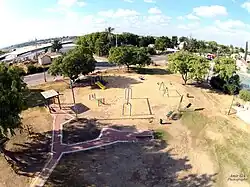
 A playground in Giv'at Ko'ah. | |
 Giv'at Ko'ah | |
| Coordinates: 32°1′48″N 34°56′10″E | |
| Grid position | 144/159 PAL |
| Country | Israel |
| District | Central |
| Council | Hevel Modi'in |
| Affiliation | Moshavim Movement |
| Founded | 1950 |
| Founded by | Yemenite immigrants |
| Population (2021)[1] | 887 |
History

During the 18th and 19th centuries, the area around Giv'at Ko'ah belonged to the Nahiyeh (sub-district) of Lod that encompassed the area of the present-day city of Modi'in-Maccabim-Re'ut in the south to the present-day city of El'ad in the north, and from the foothills in the east, through the Lod Valley to the outskirts of Jaffa in the west. This area was home to thousands of inhabitants in about 20 villages, who had at their disposal tens of thousands of hectares of prime agricultural land.[3]
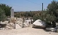
The village was founded on 2 July 1950 by immigrants from Yemen.[4] It was named for the 28 soldiers (כ"ח is the Hebrew numerals for 28) from the Alexandroni Brigade who died in fighting at Qula during the 1948 Arab-Israeli War.[5] A monument to these soldiers is located on a hill about 3 km east of the village.[6]
Giv'at Ko'ah, along with Tirat Yehuda and Bareket, is located near the former Palestinian village of village of al-Tira, which was destroyed during the 1948 Arab–Israeli War.[7]
Giv'at Ko'ah was also home to a group of Cochin Jews who emigrated from the village of Chendamangalam, India. In 2010, the Nehemiah Mott Synagogue was built in Giv'at Ko'ah, named after a Yemenite kabbalist revered by this community.[8]
References
- "Regional Statistics". Israel Central Bureau of Statistics. Retrieved 22 February 2023.
- Alexandroni Cycling and Hiking Trail in Elad Forest Jewish National Fund
- Marom, Roy (2022). "Lydda Sub-District: Lydda and its countryside during the Ottoman period". Diospolis - City of God: Journal of the History, Archaeology and Heritage of Lod. 8: 103–136.
- Mathilde A. Tagger; Yitzchak Kerem (2006). Guidebook for Sephardic and Oriental Genealogical Sources in Israel. Avotaynu.
- Talmi, Ephraim; Talmi, Menahem (September 1966). All the Land - A Geographical Lexicon of Israel (in Hebrew). Amichai Publishers. p. 117.
- History Giv'at Ko'ah
- Khalidi, Walid (1992). All That Remains: The Palestinian Villages Occupied and Depopulated by Israel in 1948. Washington D.C.: Institute for Palestine Studies. p. 418. ISBN 0-88728-224-5.
- Shalva Weil. "Where are Cochin Jews today?". cochinsyn.com.