Glen Lean
Glen Lean, in Argyll and Bute, Scotland, is an glacial-formed glen, with near vertical sides along part of the landform. It runs from the head of the Holy Loch in the east to the head of Loch Striven in the west. The only hamlet in the glen is Clachaig.[1][2] The Little Eachaig River flows out of the glen, joining the River Eachaig and flows into the Holy Loch. The Tarsan Dam is the other notable feature in the glen.[3][4]
| Glen Lean | |
|---|---|
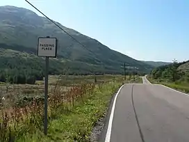 Glen Lean and the B836 | |
| Highest point | |
| Coordinates | 56.006736°N 5.0693618°W |
| Geography | |
| Location | Cowal, Argyll and Bute, Scotland. |
| Country | Scotland |
| OS grid | NS 08731 83563 |
| Geology | |
| Mountain type | Glen |
There is also the buildings at risk (unlisted) ruins of a powder mill, built c. 1840, in Clachaig.[5][1][6]
The B836, a single-track road, goes through the glen.[7] It is part of the 478 Dunoon–Portavadie bus route.[8]
References
- Clachaig, Glenlean Blackpowder Works | ScotlandsPlaces
- Glen Lean Gunpowder Mills | Canmore
- Tarsan, Loch: Overview of Tarsan, Loch
- Photo of Tarsan Dam
- "Glen Lean Gunpowder Mills, Clachaig | Buildings at Risk Register".
- Colegate's Guide to Dunoon, Kirn, and Hunter's Quay (Second edition) - John Colegate (1868), page 32
- B836 – Roader's Digest: The SABRE Wiki
- "SCOTLAND'S BERMUDA TRIANGLE". www.keybuses.com. 21 May 2020. Retrieved 26 September 2023.
This article is issued from Wikipedia. The text is licensed under Creative Commons - Attribution - Sharealike. Additional terms may apply for the media files.