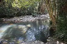
Glencoe Creek (New South Wales)
Glencoe Creek, also known as Marowin Brook is a creek in Upper Rollands Plains,[1] New South Wales, Australia. It is located in the Port Macquarie-Hastings Council area in the Mid North Coast region of New South Wales.[2][3]

Glencoe Creek, also known as Marowin Brook
Glencoe Creek starts below Tinebank Mountain at an elevation of 900 metres (3,000 ft) and flows into the Wilson River, ending at an elevation of 44.7 metres (147 ft).[4][5] The area is covered in blackbutt and tallowwood trees some 80 meters in height,[6] and is located mostly within Kumbatine National Park.
The climate is subtropical.[7]
References
- Glencoe Creek - Rollands Plains NSW.
- Glencoe Creek at aroundguides.com.
- Glencoe Creek at geoview.info.
- Map of Glencoe Creek in New South Wales .
- Traveling Luck for Glencoe Creek, New South Wales, Australia.
- Marowin Brook with Birds Nest Fern (Asplenium australasicum).
- Peel, MC; Finlayson, B L. " Updated world map of the Köppen-Geiger climate classification ." Hydrology and Earth System Sciences 11: 1633-1644.
This article is issued from Wikipedia. The text is licensed under Creative Commons - Attribution - Sharealike. Additional terms may apply for the media files.