Shire of Glenelg
The Shire of Glenelg is a local government area in the Barwon South West region of Victoria, Australia, located in the south-western part of the state. It covers an area of 6,219 square kilometres (2,401 sq mi) and in June 2018 had a population of 19,665.[1] It includes the towns of Casterton, Heywood, Merino and Portland. Although a shire of the same name existed before the amalgamations of the mid-1990s, the current Shire was formed in 1994 from the amalgamation of the former Shire of Glenelg with the Shire of Heywood and City of Portland.[2][3]
| Shire of Glenelg Victoria | |||||||||||||||
|---|---|---|---|---|---|---|---|---|---|---|---|---|---|---|---|
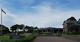 Municipal offices in Portland | |||||||||||||||
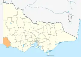 Location in Victoria | |||||||||||||||
| Population | 19,665 (2018)[1] | ||||||||||||||
| • Density | 3.1621/km2 (8.1898/sq mi) | ||||||||||||||
| Established | 1994 | ||||||||||||||
| Gazetted | 23 September 1994[2] | ||||||||||||||
| Area | 6,219 km2 (2,401.2 sq mi)[1] | ||||||||||||||
| Mayor | Cr Anita Rank | ||||||||||||||
| Council seat | Portland | ||||||||||||||
| Region | Barwon South West | ||||||||||||||
| State electorate(s) | |||||||||||||||
| Federal division(s) | Wannon | ||||||||||||||
| Website | Shire of Glenelg | ||||||||||||||
| |||||||||||||||
The Shire is governed and administered by the Glenelg Shire Council; its seat of local government and administrative centre is located at the council headquarters in Portland, it also has service centres located in Casterton and Heywood. The Shire is named after the Glenelg River, a major geographical feature that meanders through the Shire.
At the 2001 Census, the population of the Shire was distributed in the following way: Portland: 49.7%, Casterton: 8.7%, Heywood: 6.3%, Dartmoor: 1.3%, Merino: 1.1%, Narrawong: 0.9% and Rural Balance: 32%.
Service industries, timber production, grazing and manufacturing are the Shire's main economic activities.[4]
Traditional ownership
The formally recognised traditional owners for the area in which Glenelg Shire sits are the Gunditjmara People[5] who are represented by the Gunditj Mirring Traditional Owners Aboriginal Corporation.[6]
Council
Current composition
The council is composed of seven councillors elected to represent an unsubdivided municipality. The current councillors, in order of election at the 2020 election, are:[7]
| Ward | Party | Councilor | Notes | |
|---|---|---|---|---|
| Unsubdivided | Labor | Gilbert Wilson | ||
| Nationals | Anita Rank | |||
| Independent | Karen Stephens | |||
| Independent | Martin Scott | |||
| Independent | Michael Carr | |||
| Independent | Chrissy Hawker | |||
| Independent | Jayden Smith | |||
Administration and governance
The council meets in the council chambers at the council headquarters in the Portland Municipal Offices, which is also the location of the council's administrative activities. It also provides customer services at both its administrative centre in Portland, and its service centres in Casterton and Heywood.
Townships and localities
The 2021 census, the shire had a population of 20,152 up from 19,557 in the 2016 census[8]
| Population | ||
|---|---|---|
| Locality | 2016 | 2021 |
| Allestree | 128 | 168 |
| Bahgallah | 35 | 56 |
| Bessiebelle^ | 98 | 113 |
| Bolwarra | 601 | 647 |
| Branxholme^ | 351 | 304 |
| Breakaway Creek^ | 50 | 39 |
| Brimboal | 4 | 11 |
| Byaduk^ | 123 | 129 |
| Cape Bridgewater | 150 | 151 |
| Carapook^ | 70 | 67 |
| Cashmore | 228 | 197 |
| Casterton | 1,668 | 1,673 |
| Chetwynd^ | 86 | 85 |
| Clover Flat^ | 17 | 15 |
| Condah | 121 | 104 |
| Corndale | 33 | 27 |
| Population | ||
|---|---|---|
| Locality | 2016 | 2021 |
| Dartmoor | 322 | 299 |
| Dergholm^ | 43 | 57 |
| Digby | 124 | 122 |
| Drik Drik | 47 | 46 |
| Drumborg | 152 | 160 |
| Dunrobin | 73 | 70 |
| Dutton Way | 116 | 91 |
| Gorae | 188 | 236 |
| Gorae West | 227 | 237 |
| Grassdale | 18 | 54 |
| Greenwald | 51 | 58 |
| Heathmere | 237 | 238 |
| Henty | 60 | 75 |
| Heywood | 1,726 | 1,815 |
| Homerton | 23 | 36 |
| Hotspur | 45 | 34 |
| Population | ||
|---|---|---|
| Locality | 2016 | 2021 |
| Killara | 8 | 9 |
| Lake Condah^ | 6 | 9 |
| Lake Mundi | 29 | 37 |
| Lindsay | 7 | 9 |
| Lyons | 29 | 31 |
| Merino | 253 | 249 |
| Milltown | 63 | 46 |
| Mount Richmond | 43 | 42 |
| Mumbannar | 111 | 100 |
| Muntham^ | 31 | 29 |
| Myamyn | 73 | 64 |
| Nangeela | 14 | 17 |
| Nareen^ | 93 | 79 |
| Narrawong | 387 | 462 |
| Nelson | 190 | 191 |
| Population | ||
|---|---|---|
| Locality | 2016 | 2021 |
| Paschendale | 30 | 33 |
| Portland | 9,712 | 10,016 |
| Portland North | 625 | 708 |
| Portland West | 569 | 619 |
| Sandford | 144 | 130 |
| Strathdownie | 183 | 176 |
| Tahara^ | 36 | 30 |
| Tahara Bridge | 20 | 20 |
| Tahara West | 21 | 17 |
| Tyrendarra^ | 212 | 198 |
| Wallacedale^ | 113 | 94 |
| Wando Bridge | 48 | 41 |
| Wando Vale^ | 104 | 96 |
| Warrock | 28 | 46 |
| Winnap | 20 | 14 |
^ - Territory divided with another LGA
See also
References
- "3218.0 – Regional Population Growth, Australia, 2017-18: Population Estimates by Local Government Area (ASGS 2018), 2017 to 2018". Australian Bureau of Statistics. Australian Bureau of Statistics. 27 March 2019. Retrieved 25 October 2019. Estimated resident population, 30 June 2018.
- "Part 6—Shire of Glenelg". Victoria Government Gazette (1837-1997) (S63 ed.). Melbourne: Government of Victoria. 1994: 5. 23 September 1994. Retrieved 21 December 2015.
- "Part 7—Glenelg Shire". Victoria Government Gazette (1837–1997) (S4 ed.). Melbourne: Government of Victoria. 1994: 4. 20 January 1995. Retrieved 10 January 2014.
- "Glenelg Shire". Know Your Council. Retrieved 18 October 2020.
- "Map of formally recognised traditional owners". Aboriginal Victoria. Retrieved 2 June 2020.
- "Gunditj Mirring Traditional Owners Aboriginal". Gunditj Mirring Traditional Owners Aboriginal Corporation. Retrieved 2 June 2020.
- "Glenelg Shire Council election results 2020". www.vec.vic.gov.au. Retrieved 11 November 2020.
- "Census | Australian Bureau of Statistics". www.abs.gov.au. 11 January 2023.
External links
- Glenelg Shire Council official website
- Metlink local public transport map
- Link to Land Victoria interactive maps
Localities in the Shire of Glenelg | ||
|---|---|---|
| City |  | |
| Town |
| |
| Locality |
| |
^ - Territory divided with another LGA | ||