Gorfotu
Gorfotu is a village located about 45 km north of Dinajpur city in the northern part of Bangladesh. The last northern head of this village is the beginning of Panchagarh District. The Atrai River flows on the eastern side. Across the river is the Nilphamari District. Thakurgaon District is located about 20 km to the west.[1]
Gorfotu | |
|---|---|
     | |
 Gorfotu Location in Bangladesh | |
| Coordinates: 25°59′N 88°33′E | |
| Country | |
| Division | Rangpur Division |
| District | Dinajpur District |
| Time zone | UTC+6 (Bangladesh Time) |
Geography
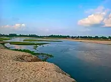
Atrai River
The village is located in Shatgram Union No. 3 of Birganj Upazila of Dinajpur District.
The Atrai River flows through the eastern side of Gorfotu Village.
Economics
The village is mainly agricultural.
Education
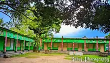
Gorfotu Government Primary School
The village has a government primary school named Gorfotu Government Primary School.[2]
Religion
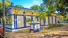
Gorfotu Baitul Nur Jame Mosque
Most of the people of Gorfotu village are Muslims. There is a Mosque called Gorfotu Baitul Noor Jame Masjid in the village for Muslims to worship.
References
- শতগ্রাম ইউনিয়ন [Shatagram Union]. Bangladesh National Portal. Retrieved 2022-09-17.
- বীরগঞ্জ উপজেলা. birganj.dinajpur.gov.bd. Retrieved 2022-10-17.
This article is issued from Wikipedia. The text is licensed under Creative Commons - Attribution - Sharealike. Additional terms may apply for the media files.