Upper Gotvand Dam
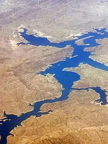
Upper Gotvand Dam, or simply the Gotvand Dam (Persian: سد گتوند بالا), is an embankment dam on the Karun River about 12 km (7.5 mi) northeast of Gotvand in Khuzestan Province, Iran. It currently has an installed capacity of 1,000 MW with another 1,000 MW in the works for a second phase. Studies for the Karun River began in the 1960s and specific designs on the Upper Gotvand were presented in 1967, 1975 and 1982. After the design and location were chosen, a further study was carried out in 1997, the same year preliminary construction (roads, bridges, river diversion) began. The river was diverted by April 2003 and excavation began soon thereafter. After completion of the dam, impounding of its reservoir began on 30 July 2011 during a ceremony attended by Iranian President Mahmood Ahmadinejad. The first generator of phase one was commissioned on 5 May 2012, two more by 18 September 2012 and the final in November 2012.[2][3] Ahmadinejad was again present for the dam's inauguration on 22 April 2013.[4] Phase 2 is estimated to be complete in 2015 and the dam is going to become one of Iran's largest power stations and is already its tallest earth-fill dam.[5][6]
| Upper Gotvand Dam | |
|---|---|
 Upper Gotvand Reservoir | |
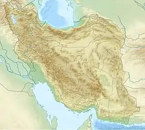
 Location of Upper Gotvand Dam in Iran | |
| Country | Iran |
| Location | Gotvand, Gotvand County, Khuzestan Province |
| Coordinates | 32°15′58″N 48°56′09″E |
| Status | Operational |
| Construction began | August 2004 |
| Opening date | 2012 |
| Owner(s) | Iran Water & Power Resources Development Co. |
| Dam and spillways | |
| Type of dam | Earthfill dam |
| Impounds | Karun River |
| Height (foundation) | 180 m (591 ft)[1] |
| Length | 760 m (2,493 ft) |
| Width (crest) | 15 m (49 ft) |
| Width (base) | 1,075 m (3,527 ft) |
| Dam volume | 28,500,000 m3 (1.006468002×10⁹ cu ft) |
| Spillways | 4 |
| Spillway type | Service, controlled ogee-type |
| Spillway capacity | 17,500 m3/s (618,007 cu ft/s) |
| Reservoir | |
| Creates | Upper Gotvand Reservoir |
| Total capacity | 4,500,000,000 m3 (3,648,209 acre⋅ft) |
| Catchment area | 32,425 km2 (12,519 sq mi) |
| Surface area | 96.5 km2 (37 sq mi) |
| Power Station | |
| Commission date | 2012 |
| Type | Conventional |
| Turbines | 4 x 250 MW Francis-type |
| Installed capacity | 1,000 MW (currently) 2,000 MW (with phase 2) |
| Annual generation | 4,500 GWh |
Downstream of the Upper Gotvand Dam is the 22 m (72 ft) high Lower Gotvand Dam at 32°16′32.51″N 48°50′8.52″E. Constructed from 1975 to 1977, it serves to divert portions of the river into two canals for the irrigation of 42,000 ha (100,000 acres) of farmland.[7][8]
References
- "Upper Gotvand Project: Technical Information". Iran Water & Power Resources Development Co. Retrieved 6 January 2012.
- "News: Third Unit of Gotvand connected to Iran's Power Grid". Iran Water and Power Resources Development Co. Retrieved 9 December 2012.
- "News: Gotvand Hydro Generation More than 1300 GWhr". Iran Water and Power Resources Development Co. 27 April 2013. Retrieved 6 May 2013.
- "News: Gotvand Dam and Hydropower Plant Inaugurated in the Presence of President Ahmadinejad". Iran Water and Power Resources Development Co. 29 April 2013. Retrieved 6 May 2013.
- "Upper Gotvand Project". IWPCO. Retrieved 26 February 2011.
- "News: Iran's Highest Earth-fill Dam Impounded in the Presence of President Ahmadinejad". Iran Water and Power Resources Development Co. Retrieved 3 September 2011.
- "Susitna Hydroelectric Project" (PDF). Harza Engineering Company. Archived from the original (PDF) on 20 January 2015. Retrieved 20 January 2015.
- "Gotvan regulatory barrier" (in Persian). Iran Dam Info. Archived from the original on 20 January 2015. Retrieved 20 January 2015.
