Wertheim am Main
Wertheim (East Franconian: Wärde) is a town in southwestern Germany, in the state of Baden-Württemberg with a population of around 23,400. It is located on the confluence of the rivers Tauber and Main. Wertheim is best known for its landmark castle and medieval town centre.
Wertheim | |
|---|---|
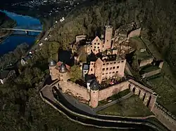 Wertheim Castle | |
 Coat of arms | |
Location of Wertheim within Main-Tauber-Kreis district 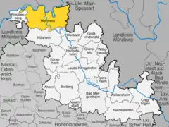 | |
 Wertheim 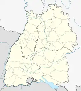 Wertheim | |
| Coordinates: 49°45′32″N 09°31′03″E | |
| Country | Germany |
| State | Baden-Württemberg |
| Admin. region | Stuttgart |
| District | Main-Tauber-Kreis |
| Subdivisions | Kernstadt, 15 Ortschaften and 5 Stadtteile |
| Government | |
| • Lord mayor (2019–27) | Markus Herrera Torrez[1] (SPD) |
| Area | |
| • Total | 138.63 km2 (53.53 sq mi) |
| Elevation | 145 m (476 ft) |
| Population (2021-12-31)[2] | |
| • Total | 22,777 |
| • Density | 160/km2 (430/sq mi) |
| Time zone | UTC+01:00 (CET) |
| • Summer (DST) | UTC+02:00 (CEST) |
| Postal codes | 97877 |
| Dialling codes | 09342, 09397 (Dertingen) |
| Vehicle registration | TBB, MGH |
| Website | www.wertheim.de |
Geography
Wertheim is the most northerly town in the state of Baden-Württemberg. It is situated at the confluence of the rivers Tauber and Main, on the Main's left bank. It borders on the Odenwald hills and the Spessart range to the north across the river Main. Wertheim is located in the Main-Tauber district.
Neighboring communities
The following towns and communities border on Wertheim, listed clockwise starting in the east: Holzkirchen, Helmstadt and Neubrunn (all district Würzburg, Bavaria), Werbach and Külsheim (both Main-Tauber district), Neunkirchen (district Miltenberg, Bavaria), Freudenberg (Main-Tauber district), Stadtprozelten and Faulbach (both Miltenberg district) and Hasloch, Kreuzwertheim and Triefenstein (all Main-Spessart district, Bavaria).
History

Wertheim was founded between the 7th and 8th century. However, the first settlement was a town called Kreuzwertheim on the right bank of the river Main. From the early 12th century onwards, a branch of the noble family of the Reginbodons called themselves after the town. After the family of the Counts of Wertheim had built a castle on the left bank of the river Main, a settlement developed at the foot of this dominating structure that was called Wertheim. It was mentioned for the first time in 779. In 1192, it was referred to as Suburbium castri Wertheim and in 1200 the town was referred to as an oppidum and in 1244 as a civitas.
Count Eberhard of Wertheim reigned from the year 1355 to 1373. In 1363 Emperor Charles IV granted him by degree the right to mint coins. The last Count of Wertheim was Michael III. He married Katharina, the oldest daughter of Ludwig of Stolberg. Michael died without producing a male heir and consequently the county passed to Ludwig of Stolberg. In 1574, after the death of Ludwig, the county passed on to his son-in-law Count Ludwig of Löwenstein.
The town developed into the center of the County of Wertheim. The county was governed by the House of Löwenstein-Wertheim. In 1630, the house split into two lines: the older Protestant line Löwenstein-Wertheim-Virneburg and the Catholic line Löwenstein-Wertheim-Rochefort. The county existed until 1806 when it was divided as a consequence of the German mediatization (Reichsdeputationshauptschluss). The area left of the Main river was given to the Grand Duchy of Baden, while the territories right of the Main were given to the Kingdom of Bavaria.
Established in 1406, the cemetery of the former Jewish community is one of the oldest in Germany. In use up until the 20th century, it is the oldest existing Jewish cemetery in Baden-Württemberg.
For many years Wertheim was home to Peden Barracks, a US Army installation. The US Army left Peden Barracks in the early 1990s as part of the post Cold War reorganization of US armed forces in Germany.
In 1938, Wertheim was merged with Tauberbischofsheim into the newly created district Landkreis Tauberbischofsheim. From 1972 onwards, 15 communities were incorporated with Wertheim. These 15 communities are: Bettingen, Dertingen, Dietenhan, Dörlesberg, Grünenwört, Höhefeld, Kembach, Lindelbach, Mondfeld, Nassig, Reicholzheim, Sachsenhausen, Sonderriet, Urphar and Waldenhausen. As of 1 January 1973 the Landkreis Tauberbischofsheim was merged into the new Main-Tauber-Kreis. Due to the incorporation of surrounding communities, Wertheim reached the 20,000 population mark in 1975. Wertheim became a Große Kreisstadt (district town) on 1 January 1976.
Demographics
|
|
¹ Census result
Arts and culture
Museums
- Glasmuseum (glass museum)
- Grafschaftsmuseum
Events
Summer festival (Altstadtfest) on the last three days of July, followed by a medieval festival at the castle followed by the Wertheimer Messe (like Oktoberfest).
Buildings
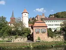
Burg Wertheim (castle) is the landmark of the town. Wertheim has a medieval town center with half-timbered houses and small streets. The Gothic Stiftskirche was built in 1383 (today it is a Protestant parish church). Two clocks can be seen on the clock tower, one with an hour hand only, for the residents of the castle. The Kilianskapelle, a Gothic chapel, was constructed after 1469. The Engelsbrunnen ("Angels' well") from 1574 was built of the red sandstone typical of this area and derives its name from two little angels holding Wertheim's coat of arms.
Other sights include the Kittsteintor with flood markings from 1595 onwards and the Blaues Haus ("Blue house").
The outlying Stadtteil of Urphar features a medieval fortified church, Jakobskirche.
Located not far from Wertheim in the Tauber valley is Bronnbach Abbey, or Kloster Bronnbach, founded in 1150. The late-Romanesque and early-Gothic basilica was consecrated in 1222.
_-_10_-_360_Panorama_der_Stadt.jpg.webp)
Economy
The glass manufacturing tradition in Wertheim and its surroundings dates back several centuries.
Governance
Mayors (Bürgermeister)
- 1810–1827: Johann Christoph Schlundt
- 1827–1829: Christoph Michael Platz
- 1829–1832: Johann Georg Weimar
- 1832–1839: Johann Friedrich Bach
- 1839–1840: Christoph Wilhelm Müller
- 1840–1845: Johann Jakob von Runkel
- 1845–1852: Ludwig Haas
- 1852–1860: Johann Jakob von Runkel
- 1860–1866: Ludwig Haas
- 1866–1871: Philipp Frank
- 1871–1880: Lorenz Meyer
- 1880–1890: Philipp Amthauer
- 1890–1895: Philipp Mayer
- 1895–1905: Michael Müller
- 1905–1933: Hans Bardon
- 1933–1938: Friedrich Bender
- 1938–1943: Hans Mensler
- 1944–1945: Hermann Dürr
- 1945: Carl Roth
- 1945–1946: Michael Beck
- 1946: Otto Hoog
- 1946–1961: Carl Roth
- 1961–1981: Karl Josef Scheuermann
- 1981–2003: Stefan Gläser
- 2003–2019: Stefan Mikulicz
- 2019–present: Markus Herrera Torrez
Coat of arms
The coat of arms of Wertheim, shows a parted shield the upper part in gold with a black eagle and below in blue three silver roses. The city flag is yellow-blue. The coat of arms is nearly unchanged in use since 1556. It is the coat of arms of the Counts of Wertheim. The meaning of the symbols is unknown.
Twin towns – sister cities
 Salon-de-Provence, France (1964)
 Godmanchester, England, United Kingdom (1981)
- Huntingdon, England, United Kingdom (1981)
 Szentendre, Hungary (1989)
- Csobánka, Hungary (1992)
 Gubbio, Italy (2006)
Notable people
- Philipp Buchner (1614–1669), composer
- Johann Philipp Förtsch (1652–1732), composer, statesman and doctor
- Matthew Klein (1911–1988), philosopher and ethicist, was born in Bettingen
- Gerd Langguth (1946–2013), political scientist
- Thomas Reis (born 1973), former professional football player, Bochum and Eintracht Frankfurt
- Henri-Joseph Rigel (1741–1799), composer
- Shimon Schwarzschild (born 1925), environmentalist, grew up in Wertheim until the age of 10[4]
- Normann Stadler (born 1973), triathlete, winner of Ironman Hawaii 2004, 2006
References
- Aktuelle Wahlergebnisse, Staatsanzeiger, accessed 13 September 2021.
- "Bevölkerung nach Nationalität und Geschlecht am 31. Dezember 2021" [Population by nationality and sex as of December 31, 2021] (CSV) (in German). Statistisches Landesamt Baden-Württemberg. June 2022.
- "Partnerstädte". wertheim.de (in German). Wertheim. Retrieved 17 February 2021.
- Jankowski, Wilfried (31 July 2010). "»Längst ein halber Wertheimer« Besuch aus Kalifornien: Jüdischer Emigrant Bert Schwarzschild zeigt seiner Frau Naomi seine Vaterstadt [Long ago Wertheimer: Visiting from California: Jewish emigrant Bert Schwarzschild shows his wife, Naomi, his hometown]". de:Main-Echo. Retrieved 26 February 2013.
External links
- Official website
 (in German)
 - Tourist site (in German)
| Ecclesiastical | 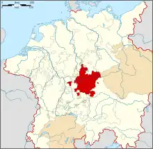 | |
|---|---|---|
| Secular |
| |
| Counts / Lords |
| |
| Cities | ||
Circles est. 1500: Bavarian, Swabian, Upper Rhenish, Lower Rhenish–Westphalian, Franconian, (Lower) Saxon Circles est. 1512: Austrian, Burgundian, Upper Saxon, Electoral Rhenish · Unencircled territories | ||
Towns and municipalities in Main-Tauber (district) | ||
|---|---|---|
Coat of arms | ||