Grade II* listed buildings in Harrogate (borough)
There are over 20,000 Grade II* listed buildings in England. This page is a list of these buildings in the district of Harrogate in North Yorkshire.
Harrogate
| Name | Location | Type | Completed [note 1] | Date designated | Grid ref.[note 2] Geo-coordinates |
Entry number [note 3] | Image |
|---|---|---|---|---|---|---|---|
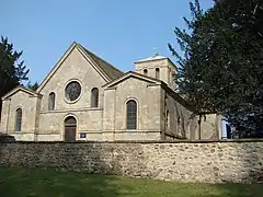
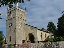
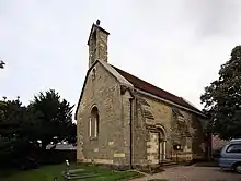
| Church of Saint Lawrence | Aldfield, Harrogate | Church | 1696 | 6 March 1967 | SE2658269471 54°07′14″N 1°35′41″W |
1149796 | 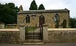 Church of Saint Lawrence |
| Chapel of St Mary attached to the Mansion | Allerton Park, Allerton Mauleverer with Hopperton, Harrogate | Roman Catholic Chapel | c. 1807 | 18 August 1983 | SE4140558064 54°01′01″N 1°22′11″W |
1149995 |  Upload Photo |
| Church of St Martin | Allerton Mauleverer, Harrogate | Church | c. 1745 | 15 March 1966 | SE4158457954 54°00′57″N 1°22′01″W |
1149996 | |
| School and School House | Baldersby, Harrogate | School | 1854 | 26 May 1971 | SE3659476885 54°11′11″N 1°26′27″W |
1150054 | 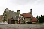 School and School House |
| The Old Vicarage | Baldersby St James, Baldersby, Harrogate | Vicarage | 1854 | 26 May 1971 | SE3667976988 54°11′14″N 1°26′22″W |
1172915 | Upload Photo |
| Bewerley Grange | Bewerley, Harrogate | House | 1679 | 6 March 1967 | SE1599164820 54°04′45″N 1°45′26″W |
1150592 | .jpg.webp) Bewerley Grange |
| Bewerley Old Hall | Bewerley, Harrogate | House | Late 16th century - Early 17th century | 23 April 1952 | SE1599464701 54°04′41″N 1°45′25″W |
1150590 | Upload Photo |
| Aldborough Hall | Aldborough, Boroughbridge, Harrogate | House | Early 17th century | 8 March 1952 | SE4081766456 54°05′33″N 1°22′39″W |
1315502 | Upload Photo |
| Barn about 100m to south of Nutwith Cote | Burton-on-Yore, Harrogate | Barn | Early-Mid 18th century | 9 August 1966 | SE2310078807 54°12′16″N 1°38′51″W |
1316885 | Upload Photo |
| Coach House and Bee Hives about 10m to north of Nutwith Cote | Burton-on-Yore, Harrogate | Beehive | 16th century | 9 August 1966 | SE2312579001 54°12′22″N 1°38′49″W |
1132066 | Upload Photo |
| Nutwith Cote | Burton-on-Yore, Harrogate | Farmhouse | 17th century | 28 April 1986 | SE2312578958 54°12′21″N 1°38′49″W |
1132064 | Upload Photo |
| Outbuilding about 20m north of Nutwith Cote | Burton-on-Yore, Harrogate | Storehouse | Early 18th century | 9 August 1966 | SE2311779027 54°12′23″N 1°38′50″W |
1316886 | Upload Photo |
| Church of St Michael | Copgrove, Harrogate | Sculpture | pre Christian | 15 March 1966 | SE3463963243 54°03′50″N 1°28′20″W |
1150343 | 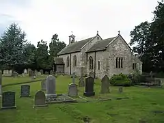 Church of St Michael |
| Church of St Helen | Denton, Harrogate | Church | 1776 | 22 November 1966 | SE1448848918 53°56′10″N 1°46′51″W |
1174421 | |
| Church of St Lawrence | Fewston, Harrogate | Church | Medieval | 14 July 1987 | SE1948254102 53°58′57″N 1°42′16″W |
1174478 | 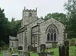 Church of St Lawrence |
| Temple of Victory with railed Enclosure | Flaxby, Harrogate | Temple | 1790 | 15 March 1966 | SE4086258410 54°01′12″N 1°22′40″W |
1315590 | 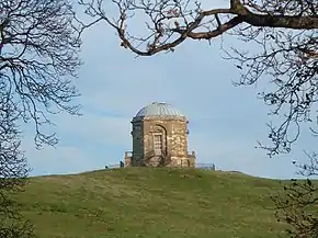 Temple of Victory with railed Enclosure |
| Bouthwaite Grange and Grange Cottage | Fountains Earth, Harrogate | House | 1673 | 6 March 1967 | SE1231971299 54°08′15″N 1°48′47″W |
1150524 | Upload Photo |
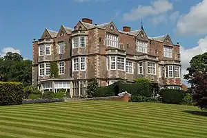
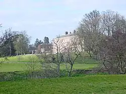
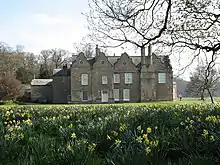
| Goldsborough Hall | Goldsborough, Harrogate | Country House | c. 1625 | 8 March 1952 | SE3836156048 53°59′57″N 1°24′59″W |
1315586 | |
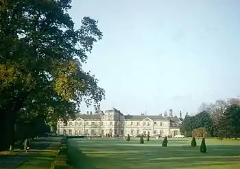
| Grantley Hall | Grantley, Harrogate | Country House | Early 18th century | 23 April 1952 | SE2417969277 54°07′08″N 1°37′54″W |
1173371 | |
| Church of St Mary | Great Ouseburn, Harrogate | Church | 1779 | 15 March 1966 | SE4491261782 54°03′00″N 1°18′56″W |
1150284 | |
| Chapel of St Andrew, Ribston Hall | Ribston Park, Great Ribston with Walshford, Harrogate | Chapel | 13th century | 15 March 1966 | SE3920453755 53°58′42″N 1°24′13″W |
1294221 | Upload Photo |
| Ribston Hall | Ribston Park, Great Ribston with Walshford, Harrogate | Country House | 1674 | 8 March 1952 | SE3918553774 53°58′43″N 1°24′14″W |
1149963 | |
| Stables to North of Ribston Hall | Ribston Park, Great Ribston with Walshford, Harrogate | House | Mid C20 | 15 March 1966 | SE3915353884 53°58′46″N 1°24′16″W |
1189567 | 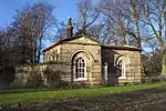 Stables to North of Ribston Hall |
| Walshford Lodge to Ribston Hall with Gatepiers and linking Walls | Walshford, Great Ribston with Walshford, Harrogate | Gate | Mid-Late 18th century | 15 March 1966 | SE4126553265 53°58′26″N 1°22′21″W |
1315596 | Walshford Lodge to Ribston Hall with Gatepiers and linking Walls |
| Spring Hall | Grewelthorpe, Harrogate | House | 1708 | 6 March 1967 | SE2471475259 54°10′21″N 1°37′22″W |
1150495 | Upload Photo |
| The Ruin, Mowbray Point | Hackfall, Grewelthorpe, Harrogate | Banqueting House | c. 1750 | 25 June 1987 | SE2323177234 54°11′25″N 1°38′44″W |
1150534 | 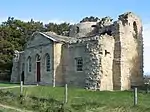 The Ruin, Mowbray Point |
| Doughill Hall | Hartwith cum Winsley, Harrogate | Apartment | c. 1980 | 23 April 1952 | SE2042161474 54°02′56″N 1°41′23″W |
1315290 | Upload Photo |
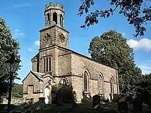
| Church of Saint Paul | Healey, Harrogate | Church | 1848 | 9 August 1966 | SE1829480670 54°13′17″N 1°43′15″W |
1132072 | .jpg.webp) Church of Saint Paul |
| Carriage Gates and Gate Piers, Pedestrian Gates, Screen Walls and Railings at New Lodge | Kirby Hall Estate, Kirby Hall, Harrogate | Gate | 18th century | 15 March 1966 | SE4523160750 54°02′27″N 1°18′39″W |
1293661 | 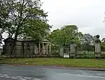 Carriage Gates and Gate Piers, Pedestrian Gates, Screen Walls and Railings at New Lodge |
| Harewood Bridge | River Wharfe, Kirkby Overblow, Harrogate | Bridge | c. 1729 | 2 September 1952 | SE3122246084 53°54′36″N 1°31′34″W |
1265837 | .jpg.webp) Harewood Bridge |
| Conyngham Hall | Conyngham Hall, Knaresborough, Harrogate | House | Late 18th century | 5 February 1952 | SE3427357394 54°00′41″N 1°28′43″W |
1315613 | 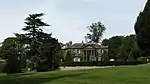 Conyngham Hall |
| Gate Piers at Scriven Park | Knaresborough, Harrogate | Gate Pier | 15 March 1966 | SE3448457808 54°00′54″N 1°28′31″W |
1263099 | 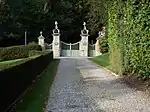 Gate Piers at Scriven Park | |
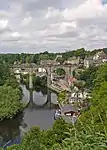
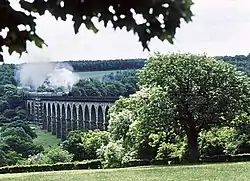
| Railway Viaduct over the River Nidd | Knaresborough, Harrogate | Railway Viaduct | 1847-51 | 15 May 1968 | SE3473457058 54°00′30″N 1°28′17″W |
1149911 | |
| Saint Robert's Cave, also called Saint Roberts Chapel, about 120m South West of Grimbald Bridge | Knaresborough, Harrogate | Chapel | 1160-1218 | 5 February 1952 | SE3610056087 53°59′58″N 1°27′03″W |
1149914 | 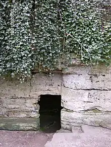 Saint Robert's Cave, also called Saint Roberts Chapel, about 120m South West of Grimbald Bridge |
| Corn Mill | Leathley, Harrogate | Corn Mill | 18th century | 22 November 1966 | SE2308847780 53°55′32″N 1°39′00″W |
1150012 | Upload Photo |
| Methodist Church and retaining Wall with Gate and Steps | Leathley, Harrogate | Gate | 1826 | 22 February 1985 | SE2343247183 53°55′13″N 1°38′41″W |
1150014 |  Methodist Church and retaining Wall with Gate and Steps |
| Half Moon Pond | Studley Royal Park, Lindrick with Studley Royal and Fountains, Harrogate | Statue | Completed 1728 | 11 June 1986 | SE2795068946 54°06′56″N 1°34′26″W |
1173896 | 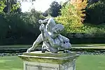 Half Moon Pond |
| High Stables | Studley Park, Lindrick with Studley Royal and Fountains, Harrogate | House | 1946 | 6 March 1967 | SE2780070014 54°07′31″N 1°34′34″W |
1149813 | Upload Photo |
| Moon and Crescent Ponds | Studley Park, Lindrick with Studley Royal and Fountains, Harrogate | Pond | 1728 | 11 June 1986 | SE2803468872 54°06′54″N 1°34′22″W |
1150612 | 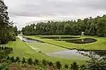 Moon and Crescent Ponds |
| Ripon Gates at East of Studley Park, with Flanking Walls and Lodges | Studley Park, Lindrick with Studley Royal and Fountains, Harrogate | Gate | Early 18th century | 6 March 1967 | SE2887569897 54°07′27″N 1°33′35″W |
1173509 | .jpg.webp) Ripon Gates at East of Studley Park, with Flanking Walls and Lodges |
| The Cottage about 100m North-east of Church of St Mary with front Garden Wall and Gate | Lindrick with Studley Royal and Fountains, Harrogate | Timber Framed House | c. 1873 | 11 June 1986 | SE2763869363 54°07′10″N 1°34′43″W |
1150601 | 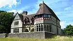 The Cottage about 100m North-east of Church of St Mary with front Garden Wall and Gate |
| The Octagon Tower | Studley Park, Lindrick with Studley Royal and Fountains, Harrogate | Tower | 1728-32 | 6 March 1967 | SE2806468977 54°06′57″N 1°34′20″W |
1296001 | 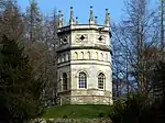 The Octagon Tower |
| Weir at North End of the Canal, with Piers, Fishing Pavilions and Balustrade | Studley Park, Lindrick with Studley Royal and Fountains, Harrogate | Balustrade | 1716-1728 | 6 March 1967 | SE2802569063 54°07′00″N 1°34′22″W |
1173821 | 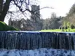 Weir at North End of the Canal, with Piers, Fishing Pavilions and Balustrade |
| Thompson Mausoleum about 20m South West of the Church of the Holy Trinity | Little Ouseburn, Harrogate | Mausoleum | Mid 18th century | 15 March 1966 | SE4520661119 54°02′39″N 1°18′40″W |
1293613 | 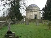 Thompson Mausoleum about 20m South West of the Church of the Holy Trinity |
| Hollin Hall | Littlethorpe, Harrogate | Country House | Late 17th century | 6 March 1967 | SE3131767286 54°06′02″N 1°31′21″W |
1293955 | Upload Photo |
| Long Marston Hall | Long Marston, Harrogate | House | Late 17th century | 2 September 1952 | SE5010651313 53°57′20″N 1°14′17″W |
1150330 | Upload Photo |
| How Hill Tower and Outbuildings, also called the Chapel of Saint Michael De Monte | Markington with Wallerthwaite, Harrogate | Chapel/Gaming House | Medieval | 13 March 1986 | SE2760067052 54°05′55″N 1°34′46″W |
1293874 | 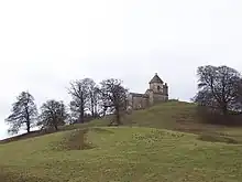 How Hill Tower and Outbuildings, also called the Chapel of Saint Michael De Monte |
| Church of Saint Mary | Masham, Harrogate | Church | 12th century | 9 August 1966 | SE2267480670 54°13′17″N 1°39′14″W |
1166880 | .jpg.webp) Church of Saint Mary |
| Church of All Saints | Moor Monkton, Harrogate | Church | 12th century | 15 March 1966 | SE5109656032 53°59′52″N 1°13′19″W |
1293654 | |
| Red House School Chapel | Moor Monkton, Harrogate | Chapel | Early 17th century | 8 March 1952 | SE5297857081 54°00′25″N 1°11′35″W |
1190840 | |
| Middle Parks Farmhouse | North Stainley with Sleningford, Harrogate | House | 14th century | 22 February 1982 | SE3019675084 54°10′14″N 1°32′20″W |
1150584 | Upload Photo |
| Stainley Hall | North Stainley with Sleningford, Harrogate | Country House | 1715 | 23 April 1952 | SE2870976522 54°11′01″N 1°33′42″W |
1174130 | Upload Photo |
| Gateway adjacent to Wath Lodge | Norton Conyers House, Harrogate | Gate | Mid to late 18th century | 22 July 1955 | SE3214676898 54°11′13″N 1°30′32″W |
1150022 | 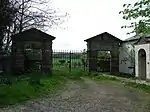 Gateway adjacent to Wath Lodge |
| Norton Conyers House | Norton Conyers, Harrogate | House | Medieval | 22 July 1955 | SE3198976245 54°10′52″N 1°30′41″W |
1150059 | |
| Stable Block with Wall and Gate Piers about 200m to west of Norton Conyers House | Norton Conyers, Harrogate | House | Late 18th century | 22 July 1955 | SE3188776321 54°10′54″N 1°30′47″W |
1173056 | 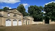 Stable Block with Wall and Gate Piers about 200m to west of Norton Conyers House |
| Scow Hall | Norwood, Harrogate | House | 16th century | 22 November 1966 | SE2011552378 53°58′02″N 1°41′42″W |
1150430 |  Scow Hall |
| Statue of a Sailors Moll and Pedestal about 20m south of the Priory | Nun Monkton, Harrogate | Statue | Early 18th century | 27 August 1987 | SE5120057886 54°00′52″N 1°13′13″W |
1191022 | Upload Photo |
| Statue of Fame and Pedestal about 35m north-east of the Priory | Nun Monkton, Harrogate | Statue | Early 18th century | 27 August 1987 | SE5119757954 54°00′54″N 1°13′13″W |
1150347 | Upload Photo |
| Statue of Girl with Birds Nest and Pedestal about 30m east of the Priory | Nun Monkton, Harrogate | Statue | Early 18th century | 27 August 1987 | SE5120557898 54°00′52″N 1°13′12″W |
1150345 | Upload Photo |
| Statue of Mars and Pedestal about 40m south of the Priory | Nun Monkton, Harrogate | Statue | Early 18th century | 27 August 1987 | SE5122957920 54°00′53″N 1°13′11″W |
1150346 | Upload Photo |
| Statue of Minerva and Pedestal about 40m east of the Priory | Nun Monkton, Harrogate | Statue | Early 18th century | 27 August 1987 | SE5122257918 54°00′53″N 1°13′11″W |
1315385 | Upload Photo |
| Statue of Shepherd with Pipe and Pedestal about 20m south-west of the Priory | Nun Monkton, Harrogate | Statue | Early 18th century | 27 August 1987 | SE5117157882 54°00′52″N 1°13′14″W |
1191014 | Upload Photo |
| Statue of the Buccaneer and Pedestal about 20m south of the Priory | Nun Monkton, Harrogate | Statue | Early 18th century | 27 August 1987 | SE5118557882 54°00′52″N 1°13′13″W |
1315384 | Upload Photo |
| Statue of the Haymaker and Pedestal about 35m north of the Priory | Nun Monkton, Harrogate | Statue | Early 18th century | 27 August 1987 | SE5117757944 54°00′54″N 1°13′14″W |
1293538 | Upload Photo |
| The Priory | Nun Monkton, Harrogate | House | c. 1660 | 8 March 1952 | SE5117457910 54°00′53″N 1°13′14″W |
1315383 | Upload Photo |
| Weir and Salmon Ladder | Linton Lock, Nun Monkton, Harrogate | Weir | c. 1767 | 20 October 1986 | SE4998760019 54°02′01″N 1°14′18″W |
1293712 | Upload Photo |
| Plompton Hall and flanking Walls | Plompton, Harrogate | Country House | c. 1760 | 8 March 1952 | SE3572154009 53°58′51″N 1°27′24″W |
1149836 | .jpg.webp) Plompton Hall and flanking Walls |
| Stables to Plompton Hall | Plompton Hall, Plompton, Harrogate | House | c. 1757 | 15 March 1966 | SE3570354013 53°58′51″N 1°27′25″W |
1191416 | Stables to Plompton Hall |
| Orangery with flanking Walls, Bothys, Glasshouse and Pavilions at Ripley Castle | Ripley Park, Ripley, Harrogate | Bothy | c. 1785 | 15 March 1966 | SE2839260747 54°02′31″N 1°34′05″W |
1315394 | 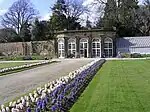 Orangery with flanking Walls, Bothys, Glasshouse and Pavilions at Ripley Castle |
| Stables, Coach Houses and Service Buildings to North and East of Courtyard at Ripley Castle with South Wall to Gate House | Ripley Park, Ripley, Harrogate | Bothy | Begun 1786 | 18 May 1987 | SE2827260595 54°02′26″N 1°34′11″W |
1174114 | 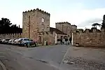 Stables, Coach Houses and Service Buildings to North and East of Courtyard at Ripley Castle with South Wall to Gate House |
| Church of All Saints | Ripley, Harrogate | Church | c. 1400 | 15 March 1966 | SE2833260505 54°02′23″N 1°34′08″W |
1174051 | 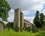 Church of All Saints |
| Weeping Cross about 5m north of Church of All Saints | Ripley, Harrogate | Cross | Medieval | 15 March 1966 | SE2833960518 54°02′24″N 1°34′08″W |
1315369 | 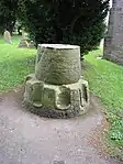 Weeping Cross about 5m north of Church of All Saints |
| Bishopton Lodge | Ripon, Harrogate | Stewards House | Mid 18th century | 27 May 1949 | SE3005670895 54°07′59″N 1°32′29″W |
1296147 | Upload Photo |
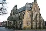
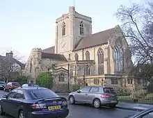
| Church of St Wilfrid | Ripon, Harrogate | Roman Catholic Church | 1858-62 | 19 March 1984 | SE3107371544 54°08′20″N 1°31′33″W |
1173834 | |
| Deans Croft | Ripon, Harrogate | House | 1958 | 27 May 1949 | SE3156071317 54°08′12″N 1°31′06″W |
1315485 | Upload Photo |
| Gazebos in Gardens of Nos 7 & 8, Park Street | Ripon, Harrogate | Gazebo | Early 18th century | 27 May 1949 | SE3094571350 54°08′13″N 1°31′40″W |
1150140 | Upload Photo |
| Minster House | Ripon, Harrogate | House | 18th century | 27 May 1949 | SE3140371072 54°08′04″N 1°31′15″W |
1149408 | .jpg.webp) Minster House |
| Remains of mediaeval St Anne's Hospital | Ripon, Harrogate | Ruin | 14th century | 27 May 1949 | SE3146271005 54°08′02″N 1°31′12″W |
1174023 | 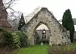 Remains of mediaeval St Anne's Hospital |
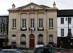
| Ripon Town Hall | Ripon, Harrogate | Town Hall | 1799 | 27 May 1949 | SE3121071216 54°08′09″N 1°31′26″W |
1174370 | |
| St Agnes House | Ripon, Harrogate | House | 1693 | 27 May 1949 | SE3152571026 54°08′03″N 1°31′08″W |
1149395 | 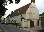 St Agnes House |
| The Court House | Ripon, Harrogate | Court House | 1830 | 27 May 1949 | SE3140071202 54°08′09″N 1°31′15″W |
1174464 | .jpg.webp) The Court House |
| The Old Deanery | Ripon, Harrogate | Deanery | Mid 17th century | 27 May 1949 | SE3147671185 54°08′08″N 1°31′11″W |
1150165 | 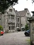 The Old Deanery |
| The Old Hall | Ripon, Harrogate | House | 1738 | 27 May 1949 | SE3145771029 54°08′03″N 1°31′12″W |
1149393 | Upload Photo |
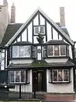
| The Wakeman's House | Ripon, Harrogate | House | 16th century | 27 May 1949 | SE3117171234 54°08′10″N 1°31′28″W |
1295808 | |
| Thorpe Prebend House | Ripon, Harrogate | Clergy House | Mid 17th century | 27 May 1949 | SE3143070996 54°08′02″N 1°31′14″W |
1295988 | 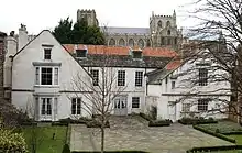 Thorpe Prebend House |
| Church of St Mary | Roecliffe, Harrogate | Church | 1843 | 15 March 1966 | SE3756266019 54°05′19″N 1°25′38″W |
1150316 | |
| Scotton Old Hall | Scotton, Harrogate | House | 17th century | 8 March 1952 | SE3253059558 54°01′52″N 1°30′18″W |
1150318 | .jpg.webp) Scotton Old Hall |
| Home Farmhouse | Old Scriven, Scriven, Harrogate | House | C18-C19 | 15 March 1966 | SE3479558398 54°01′14″N 1°28′14″W |
1263238 | Upload Photo |
| Sharow Cross (National Trust) | Sharow, Harrogate | Cross | 13th century | 6 March 1967 | SE3235271977 54°08′33″N 1°30′23″W |
1149835 | 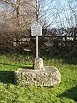 Sharow Cross (National Trust) |
| Church of All Saints | Spofforth with Stockeld, Harrogate | Church | Late 12th century | 30 March 1966 | SE3646451079 53°57′16″N 1°26′45″W |
1149981 | |
| Pigeon House about 120m north of Stockeld Park House | Spofforth with Stockeld, Harrogate | Dovecote | 1758-63 | 11 July 1983 | SE3717449428 53°56′23″N 1°26′07″W |
1315562 | Upload Photo |
| Spofforth Castle, Ruins | Spofforth with Stockeld, Harrogate | Fortified House | 13th century | 22 February 1985 | SE3602751100 53°57′17″N 1°27′09″W |
1149976 | 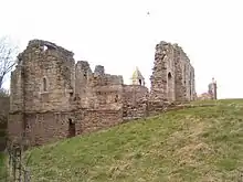 Spofforth Castle, Ruins |
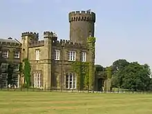
| Swinton Castle | Swinton Park, Swinton with Warthermarske, Harrogate | Country House | 18th century | 9 August 1966 | SE2118579724 54°12′46″N 1°40′36″W |
1167546 | |
| Old Thornville | Thornville, Harrogate | Country House | Mid-Late 17th century | 15 March 1966 | SE4563054698 53°59′11″N 1°18′20″W |
1294065 | Upload Photo |
| Thorpe Underwood Hall | Thorpe Underwoods, Harrogate | Country House | 1902-03 | 15 January 1980 | SE4632959252 54°01′38″N 1°17′39″W |
1315423 | Upload Photo |
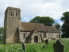
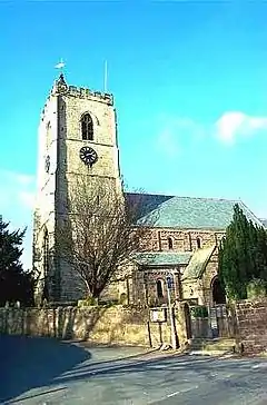
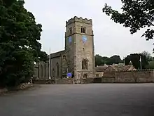
| Church of St Mary | Wath, Harrogate | Church | 13th century | 22 July 1955 | SE3251377152 54°11′21″N 1°30′12″W |
1173160 | 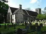 Church of St Mary |
| Church of St Barnabas | Weeton, Harrogate | Church | 1851-3 | 30 March 1966 | SE2838346503 53°54′50″N 1°34′10″W |
1149990 | 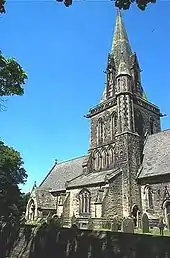 Church of St Barnabas |
| Barn, later Coach-house and Stables, about 20m south of Weston Hall | Weston, Harrogate | Barn | 17th century | 22 November 1966 | SE1776846677 53°54′57″N 1°43′52″W |
1150439 | Upload Photo |
| Church of the Ascension | Whixley, Harrogate | Church | Early 14th century | 15 March 1966 | SE4420458297 54°01′08″N 1°19′37″W |
1189906 | 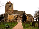 Church of the Ascension |
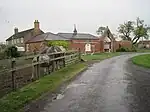
| Bilton Grove Farmhouse | Daw Cross, Harrogate | Farmhouse | c. 1662 | 18 July 1949 | SE2939751556 53°57′33″N 1°33′12″W |
1149442 | Upload Photo |
| Church of St Mary | Harrogate | Church | c. 1916 | 4 February 1975 | SE2949154747 53°59′17″N 1°33′06″W |
1149482 | |
| Crimple Valley Viaduct | Crimple, Harrogate | Viaduct | c. 1848 | 4 February 1975 | SE3178953106 53°58′23″N 1°31′01″W |
1189723 | |
| Grove House | Harrogate | House | 1897-1902 | 4 February 1975 | SE3071656290 54°00′06″N 1°31′58″W |
1149433 | |
| Hill Top Hall | Daw Cross, Harrogate | Farmhouse | 17th century | 18 July 1949 | SE2902551610 53°57′35″N 1°33′33″W |
1149443 | Upload Photo |
| Parish Church of St John | Bilton, Harrogate | Parish Church | Circa 1851-7 | 4 February 1975 | SE3045257007 54°00′29″N 1°32′13″W |
1315827 | _002.JPG.webp) Parish Church of St John |
| Parish Church of St Robert of Knaresborough | Pannal, Harrogate | Church Hall | C20 | 18 July 1949 | SE3062051694 53°57′38″N 1°32′05″W |
1149449 | |
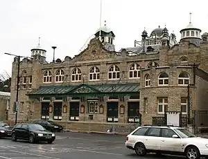
| Royal Hall | Harrogate | Concert Hall | 1903 | 4 February 1975 | SE2999455588 53°59′44″N 1°32′38″W |
1315842 | |
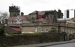
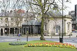
| Royal Pump Room Museum | Harrogate | Museum | 1953 | 18 July 1949 | SE2981455374 53°59′37″N 1°32′48″W |
1149478 | |
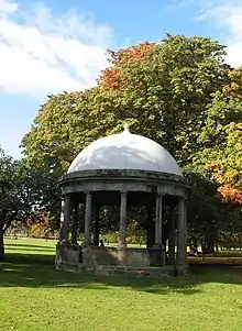
| St John's Well | Harrogate | Pavilion | 1842 | 18 July 1949 | SE3150555359 53°59′36″N 1°31′15″W |
1281537 | 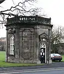 St John's Well |
| Tewit Well | Harrogate | Pavilion | c. 1804 | 18 July 1949 | SE3061854467 53°59′07″N 1°32′04″W |
1293847 | |
| White Hart Hotel | Harrogate | Hotel | c. 1846 | 15 June 1971 | SE2986455271 53°59′33″N 1°32′46″W |
1315821 | |
| 29 and 30, Regent Parade | Harrogate | Shops | Late 18th century | 4 February 1975 | SE3091755860 53°59′52″N 1°31′48″W |
1149432 | 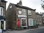 29 and 30, Regent Parade |
| 1–4 West Park | Harrogate | Terrace | Earlier 19th century | 18 July 1949 | SE3021254984 53°59′24″N 1°32′27″W |
1149400 | 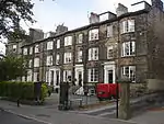 1–4 West Park |
| Harrogate War Memorial | Harrogate | War memorial | 1923 | 14 June 2017 | SE3013355280 53°59′34″N 1°32′31″W |
1446943 | 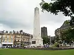 Harrogate War Memorial |
.JPG.webp)
Notes
- The date given is the date used by Historic England as significant for the initial building or that of an important part in the structure's description.
- Sometimes known as OSGB36, the grid reference is based on the British national grid reference system used by the Ordnance Survey.
- The "List Entry Number" is a unique number assigned to each listed building and scheduled monument by Historic England.
External links
![]() Media related to Grade II* listed buildings in Harrogate at Wikimedia Commons
Media related to Grade II* listed buildings in Harrogate at Wikimedia Commons
This article is issued from Wikipedia. The text is licensed under Creative Commons - Attribution - Sharealike. Additional terms may apply for the media files.