Grade II* listed buildings in Huntingdonshire
There are over 20,000 Grade II* listed buildings in England. This page is a list of these buildings in the district of Huntingdonshire in Cambridgeshire.
List
| Name | Location | Type | Completed [note 1] | Date designated | Grid ref.[note 2] Geo-coordinates |
Entry number [note 3] | Image |
|---|---|---|---|---|---|---|---|
| Church of St Margaret | Abbotsley, Huntingdonshire | Church | 16th century | 14 May 1959 | TL2277556538 52°11′36″N 0°12′19″W |
1210868 | |
| Manor Farmhouse | Alconbury, Huntingdonshire | Farmhouse | Early to mid 17th century | 21 July 1951 | TL1849876081 52°22′12″N 0°15′39″W |
1130210 |  Upload Photo |
| Milepost | Alconbury Weston, Huntingdonshire | Milepost | c. 1770 | 21 October 1983 | TL1863078130 52°23′18″N 0°15′30″W |
1130211 | 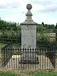 Milepost |
| Alwalton Lodge | Alwalton, Huntingdonshire | House | Early 19th century | 16 November 1988 | TL1344596095 52°33′03″N 0°19′42″W |
1130085 | 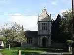 Alwalton Lodge |
| The Manor House | Alwalton, Huntingdonshire | Manor House | Early 17th century to Mid 17th century | 25 September 1951 | TL1348296172 52°33′06″N 0°19′40″W |
1164628 | Upload Photo |
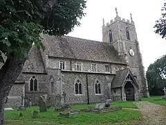
| Parish Church of St Giles | Barham, Barham and Woolley, Huntingdonshire | Parish Church | Late 12th century | 28 January 1958 | TL1370575466 52°21′56″N 0°19′53″W |
1130126 | 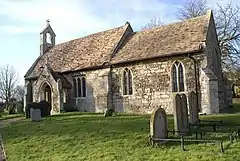 Parish Church of St Giles |
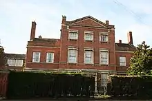
| Bluntisham House | Bluntisham, Huntingdonshire | Vicarage | c. 1720 | 24 October 1951 | TL3681774494 52°21′05″N 0°00′26″E |
1162482 | Upload Photo |
| Stapenhill | Bluntisham, Huntingdonshire | Farmhouse | Mid 18th century | 30 May 1958 | TL3677274620 52°21′09″N 0°00′24″E |
1309640 | Upload Photo |
| Walnut Trees | Bluntisham, Huntingdonshire | House | 18th century | 24 October 1951 | TL3673974845 52°21′17″N 0°00′23″E |
1330735 | Upload Photo |
| Parish Church of All Saints | Brington, Brington and Molesworth, Huntingdonshire | Parish Church | 14th century | 28 January 1958 | TL0825775958 52°22′16″N 0°24′41″W |
1130131 | 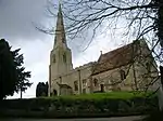 Parish Church of All Saints |
| Parish Church of St Peter | Molesworth, Brington and Molesworth, Huntingdonshire | Sundial | Late 13th century | 28 January 1958 | TL0702475805 52°22′11″N 0°25′46″W |
1130132 | 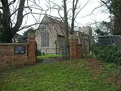 Parish Church of St Peter |
| The Old Manor House | Brington, Brington and Molesworth, Huntingdonshire | Farmhouse | Mid 16th century | 9 March 1973 | TL0847375989 52°22′16″N 0°24′29″W |
1317752 | Upload Photo |
| Parish Church of All Saints | Broughton, Huntingdonshire | Parish Church | 12th century | 30 May 1958 | TL2806377907 52°23′03″N 0°07′11″W |
1128531 | 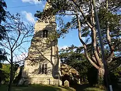 Parish Church of All Saints |
| Outer Gateway and Boundary Wall, 50, High St | Buckden, Huntingdonshire | Boundary Wall | Late 15th century | 24 October 1951 | TL1916767696 52°17′40″N 0°15′15″W |
1161771 | Upload Photo |
| The Manor House & Three Willows | Buckden, Huntingdonshire | Houses | Early 17th century | 24 October 1951 | TL1928867590 52°17′37″N 0°15′08″W |
1161627 | Upload Photo |
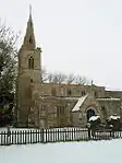
| Parish Church of All Saints | Buckworth, Huntingdonshire | Parish Church | 12th century | 28 January 1958 | TL1480976786 52°22′38″N 0°18′53″W |
1130189 | 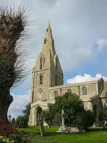 Parish Church of All Saints |
| Parish Church of St Lawrence | Bythorn, Bythorn and Keyston, Huntingdonshire | Parish church | Late 13th century | 28 January 1958 | TL0570275911 52°22′16″N 0°26′56″W |
1130139 | 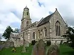 Parish Church of St Lawrence |
| All Saints' Church (previously St Margaret's Church) | Covington, Huntingdonshire | Church | 12th century | 14 May 1959 | TL0544370773 52°19′30″N 0°27′15″W |
1214317 | 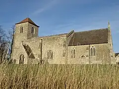 All Saints' Church (previously St Margaret's Church) |
| Former Parish Church of St Mary Magdalene | Caldecote, Denton and Caldecote, Huntingdonshire | Dwelling | Recent | 13 December 1957 | TL1408388420 52°28′54″N 0°19′18″W |
1215182 | 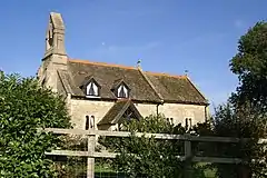 Former Parish Church of St Mary Magdalene |
| Church of St Lawrence | Diddington, Huntingdonshire | Church | 13th century | 14 May 1959 | TL1904465956 52°16′44″N 0°15′23″W |
1130308 | 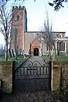 Church of St Lawrence |
| Woodlands | Earith, Huntingdonshire | House | 18th century | 30 May 1958 | TL3851774776 52°21′13″N 0°01′57″E |
1128505 | Upload Photo |
| 91 High Street | Earith, Huntingdonshire | Farmhouse | Early 18th century | 4 November 1982 | TL3829974835 52°21′15″N 0°01′45″E |
1162718 | Upload Photo |
| Parish Church of All Saints | Overend, Elton, Huntingdonshire | Parish Church | c. 1270 | 13 December 1957 | TL0887193562 52°31′45″N 0°23′48″W |
1317486 | 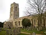 Parish Church of All Saints |
| Service Range or Former Stable Range circa 20 Metres South East of Elton Hall on the South-western Side of the Open Courtyard | Elton, Huntingdonshire | Stable | Early 18th century | 16 November 1988 | TL0887592948 52°31′25″N 0°23′48″W |
1164913 | Upload Photo |
| Stables Circa 30 Metres East of Elton Hall | Elton, Huntingdonshire | House | c. 1870 | 16 November 1988 | TL0893392975 52°31′26″N 0°23′45″W |
1130095 | Upload Photo |
| Church of St Mary | Farcet, Huntingdonshire | Parish Church | 12th century | 13 December 1957 | TL2016994639 52°32′11″N 0°13′47″W |
1215281 |  Church of St Mary |
| Grove House | Fenstanton, Huntingdonshire | House | Early 18th century | 24 October 1951 | TL3139068498 52°17′56″N 0°04′29″W |
1128485 | 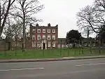 Grove House |
| Kirkby Cottage, Windwhistle & Ye Old Croft | Fenstanton, Huntingdonshire | Farmhouse | Early 17th century | 30 May 1958 | TL3186068724 52°18′03″N 0°04′04″W |
1162784 | Upload Photo |
| Manor House, Cambridge Rd | Fenstanton, Huntingdonshire | Farmhouse | Early-mid 18th century | 24 October 1951 | TL3107468760 52°18′05″N 0°04′45″W |
1128510 | Upload Photo |
| The Manor House, Chequer St | Fenstanton, Huntingdonshire | Manor House | 17th century | 30 May 1958 | TL3177568759 52°18′04″N 0°04′08″W |
1128512 | .jpg.webp) The Manor House, Chequer St |
| Parish Church of St Helen | Folksworth and Washingley, Huntingdonshire | Parish Church | c. 1150 | 13 December 1957 | TL1464490356 52°29′57″N 0°18′45″W |
1317442 |  Parish Church of St Helen |
| Farm Hall | Godmanchester, Huntingdonshire | Farmhouse | 1746 | 28 November 1950 | TL2421970186 52°18′57″N 0°10′45″W |
1128580 |  Farm Hall |
| Island Hall | Godmanchester, Huntingdonshire | House | Mid 18th century | 28 November 1950 | TL2439270793 52°19′16″N 0°10′35″W |
1330716 | |
| Meadow Wall facing Number 24 | Godmanchester, Huntingdonshire | Gate Pier | 18th century | 27 May 1977 | TL2420770208 52°18′57″N 0°10′45″W |
1330709 | Upload Photo |
| The Chinese Bridge | Godmanchester, Huntingdonshire | Ornamental Bridge | 1827 | 29 May 1969 | TL2443670584 52°19′09″N 0°10′33″W |
1128661 |  The Chinese Bridge |
| Tudor House, 2 Earning St | Godmanchester, Huntingdonshire | Timber Framed House | c1600-1603 | 28 November 1950 | TL2487870468 52°19′05″N 0°10′10″W |
1330671 | 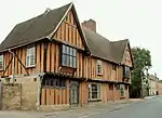 Tudor House, 2 Earning St |
| Two Piers and Railings at No 24 along Street front | Godmanchester, Huntingdonshire | Gate Pier | Mid 18th century | 27 May 1977 | TL2420970191 52°18′57″N 0°10′45″W |
1162402 | Upload Photo |
| Parish Church of St Michael | Great Gidding, Huntingdonshire | Parish Church | Mid 13th century | 28 January 1958 | TL1165583130 52°26′05″N 0°21′33″W |
1130104 | 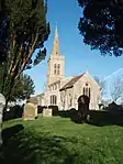 Parish Church of St Michael |
| Barn to East of Old Barn Farmhouse | Great Gransden, Huntingdonshire | Barn | Early 17th century | 24 October 1951 | TL2681155778 52°11′08″N 0°08′47″W |
1211238 | Upload Photo |
| Marley's Cottage | Great Gransden, Huntingdonshire | House | 17th century | 18 November 1983 | TL2707955840 52°11′10″N 0°08′33″W |
1211199 | Upload Photo |
| Post Mill | Great Gransden, Huntingdonshire | Post Mill | c. 1612 | 18 November 1983 | TL2771755522 52°10′59″N 0°08′00″W |
1211279 | 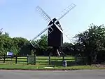 Post Mill |
| Rippington Manor | Great Gransden, Huntingdonshire | Farmhouse | 16th century | 24 October 1951 | TL2715455605 52°11′03″N 0°08′30″W |
1290193 | Upload Photo |
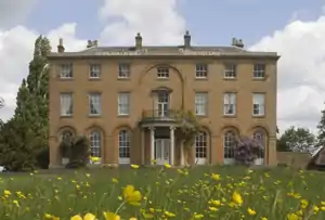
| Place House | Great Staughton, Huntingdonshire | Country House | 1539-57 | 24 October 1951 | TL1231764680 52°16′08″N 0°21′20″W |
1288544 | Upload Photo |
| Parish Church of St Mary | Haddon, Huntingdonshire | Parish Church | 11th century | 13 December 1957 | TL1343692489 52°31′07″N 0°19′47″W |
1274855 | 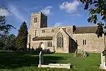 Parish Church of St Mary |
| Parish Church of St Nicholas | Hail Weston, Huntingdonshire | Parish Church | 13th century | 14 May 1959 | TL1652062079 52°14′40″N 0°17′41″W |
1330437 | 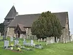 Parish Church of St Nicholas |
| Parish Church of St Andrew | Steeple Gidding, Hamerton and Steeple Gidding, Huntingdonshire | Parish Church | 12th century | 28 January 1958 | TL1320581355 52°25′07″N 0°20′13″W |
1130118 | |
| Parish of All Saints | Hamerton, Hamerton and Steeple Gidding, Huntingdonshire | Parish Church | 13th century | 28 January 1958 | TL1371379656 52°24′11″N 0°19′48″W |
1222799 | 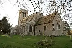 Parish of All Saints |
| Hemingford Park Hall | Hemingford Abbots, Huntingdonshire | Country House | 1842-3 | 24 October 1951 | TL2761570942 52°19′18″N 0°07′45″W |
1330770 | Upload Photo |
| The Old Rectory | Hemingford Abbots, Huntingdonshire | House | Now | 4 November 1982 | TL2822871169 52°19′25″N 0°07′12″W |
1309410 | Upload Photo |
| Broom Lodge | Hemingford Grey, Huntingdonshire | House | Early 18th century | 30 May 1958 | TL2923070648 52°19′07″N 0°06′20″W |
1128477 | Upload Photo |
| Hemingford Grey House | Hemingford Grey, Huntingdonshire | House | 1697 | 24 October 1951 | TL2929270950 52°19′17″N 0°06′16″W |
1163066 | 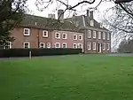 Hemingford Grey House |
| River House | Hemingford Grey, Huntingdonshire | House | Mid 18th century | 24 October 1951 | TL2913670722 52°19′10″N 0°06′25″W |
1163089 | 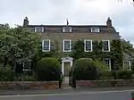 River House |
| The Anchor | Hemingford Grey, Huntingdonshire | Open Hall House | Mid-late 16th century | 4 November 1982 | TL2930970782 52°19′12″N 0°06′15″W |
1163059 | 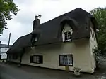 The Anchor |
| Hilton Hall, Gate Piers Forecourt Wall | Hilton, Huntingdonshire | House | Early 17th century | 24 October 1951 | TL2908866366 52°16′49″N 0°06′33″W |
1163219 | Upload Photo |
| St Johns College Farmhouse | Hilton, Huntingdonshire | Farmhouse | 15th century | 24 October 1951 | TL2864466504 52°16′54″N 0°06′56″W |
1330759 | Upload Photo |
| Parish Church of St Giles | Holme, Huntingdonshire | Parish Church | 12th century | 13 December 1957 | TL1893287968 52°28′36″N 0°15′01″W |
1215533 | 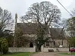 Parish Church of St Giles |
| Anchor Cottage | Holywell, Holywell-cum-Needingworth, Huntingdonshire | House | 17th century | 16 August 1971 | TL3411470602 52°19′02″N 0°02′02″W |
1163321 | Upload Photo |
| The Chestnuts | Needingworth, Holywell-cum-Needingworth, Huntingdonshire | Farmhouse | 1710 | 24 October 1951 | TL3450072314 52°19′57″N 0°01′39″W |
1330788 | Upload Photo |
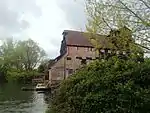
| Houghton Mill | Houghton, Houghton and Wyton, Huntingdonshire | Watermill | rebuilt from 18th century | 24 October 1951 | TL2815871971 52°19′51″N 0°07′14″W |
1128403 | |
| Manor Farmhouse | Houghton, Houghton and Wyton, Huntingdonshire | Farmhouse | Late 16th century | 30 May 1958 | TL2827272335 52°20′03″N 0°07′08″W |
1128408 | Upload Photo |
| 1 The Green | Houghton, Houghton and Wyton, Huntingdonshire | House | 1983 | 4 November 1982 | TL2817472231 52°20′00″N 0°07′13″W |
1163390 | Upload Photo |
| Castle Hill House | Huntingdon, Huntingdonshire | House | 1787 | 23 July 1969 | TL2406371584 52°19′42″N 0°10′51″W |
1128637 | 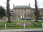 Castle Hill House |
| Church of All Saints | Hartford, Huntingdon, Huntingdonshire | Church | Early 12th century | 10 January 1951 | TL2558572550 52°20′12″N 0°09′30″W |
1330670 | 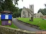 Church of All Saints |
| Cowper House | Huntingdon, Huntingdonshire | House | Early 18th century or earlier | 10 January 1951 | TL2399371651 52°19′44″N 0°10′55″W |
1128638 | Upload Photo |
| Cromwell Museum | Huntingdon, Huntingdonshire | Grammar School | 1854-1856 | 10 January 1951 | TL2380671856 52°19′51″N 0°11′04″W |
1161870 | 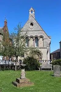 Cromwell Museum |
| Park Wall of Hinchingbrooke House Fronting Brampton Road | Huntingdon, Huntingdonshire | Park Wall | 17th century | 27 May 1977 | TL2270871372 52°19′36″N 0°12′03″W |
1128652 | Upload Photo |
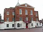
| The George Hotel | Huntingdon, Huntingdonshire | Hotel | Late 17th century | 10 January 1951 | TL2374971871 52°19′52″N 0°11′07″W |
1161746 | 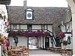 The George Hotel |
| The Manor House | Hartford, Huntingdon, Huntingdonshire | Jettied House | Late 15th century or early 16th century | 10 January 1951 | TL2574972799 52°20′20″N 0°09′21″W |
1128627 | Upload Photo |
| Town Hall | Huntingdon, Huntingdonshire | Town Hall | 1745 | 10 January 1951 | TL2382471797 52°19′49″N 0°11′04″W |
1128584 | |
| Walden House | Huntingdon, Huntingdonshire | House | Late 17th century | 10 January 1951 | TL2377071820 52°19′50″N 0°11′06″W |
1128590 | |
| 28 High Street | Huntingdon, Huntingdonshire | House | Early 18th century | 10 January 1950 | TL2402471651 52°19′44″N 0°10′53″W |
1161677 | Upload Photo |
| Court House | Kimbolton, Huntingdonshire | House | Late 17th century or early 18th century | 24 October 1951 | TL0990367792 52°17′50″N 0°23′23″W |
1290388 | Upload Photo |
| La Cote d'Or Restaurant | Kimbolton, Huntingdonshire | House | 16th century | 24 October 1951 | TL0993067761 52°17′49″N 0°23′22″W |
1210579 | Upload Photo |
| Main and Side Gates and Four Gate Piers to South East of Kimbolton School | Kimbolton, Huntingdonshire | Gate | Early 18th century | 24 October 1951 | TL1042767519 52°17′41″N 0°22′56″W |
1210891 |  Main and Side Gates and Four Gate Piers to South East of Kimbolton School |
| Two Flights of Stone Steps, to East Front of Kimbolton School | Kimbolton, Huntingdonshire | Steps | Early 18th century | 28 April 1983 | TL1010967575 52°17′43″N 0°23′13″W |
1221025 | Upload Photo |
| Warren House | Kimbolton, Huntingdonshire | House | 1979 | 15 November 1979 | TL1067668354 52°18′08″N 0°22′42″W |
1211750 | Upload Photo |
| White House | Kimbolton, Huntingdonshire | House | Late 18th century or early 19th century | 24 October 1951 | TL0988967807 52°17′51″N 0°23′24″W |
1210624 | Upload Photo |
| 5 East Street | Kimbolton, Huntingdonshire | House | Early 18th century | 24 October 1951 | TL1005267752 52°17′49″N 0°23′16″W |
1290574 | Upload Photo |
| Church of St Peter | Kings Ripton, Huntingdonshire | Parish Church | 13th century | 28 January 1958 | TL2611776582 52°22′22″N 0°08′56″W |
1309498 | 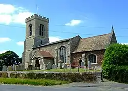 Church of St Peter |
| The Castle | Leighton, Huntingdonshire | House | Mid 17th century | 21 July 1951 | TL1166875210 52°21′49″N 0°21′41″W |
1330513 | Upload Photo |
| Little Paxton Hall | Little Paxton, Huntingdonshire | House | Mid 17th century | 24 October 1951 | TL1872762898 52°15′05″N 0°15′44″W |
1162401 | Upload Photo |
| Parish Church of St James | Little Paxton, Huntingdonshire | Parish Church | Late 12th century | 14 May 1959 | TL1890262760 52°15′01″N 0°15′35″W |
1130279 | 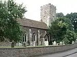 Parish Church of St James |
| Church of All Saints | Offord Cluny, Offord Cluny and Offord D'Arcy, Huntingdonshire | Church | 13th century | 14 May 1959 | TL2185567042 52°17′17″N 0°12′54″W |
1130281 | 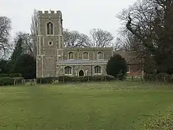 Church of All Saints |
| Manor House | Offord Cluny and Offord D'Arcy, Huntingdonshire | Farmhouse | 1613 | 3 June 1983 | TL2164066366 52°16′55″N 0°13′06″W |
1130248 | Upload Photo |
| Church of St Peter | Old Hurst, Huntingdonshire | Parish Church | 13th century | 30 May 1958 | TL3001277303 52°22′42″N 0°05′29″W |
1163560 | 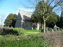 Church of St Peter |
| Parish Church of St Swithin | Old Weston, Huntingdonshire | Church | c. 1200 | 28 January 1958 | TL0939577206 52°22′55″N 0°23′39″W |
1130116 | 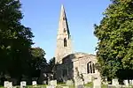 Parish Church of St Swithin |
| Gaynes Hall | West Perry, Perry, Huntingdonshire | House | Late 17th century | 28 April 1983 | TL1466366223 52°16′56″N 0°19′14″W |
1288478 | |
| Fenton Manor Farmhouse | Fenton, Pidley cum Fenton, Huntingdonshire | Farmhouse | Early 18th century | 24 October 1951 | TL3209879645 52°23′56″N 0°03′36″W |
1330787 | Upload Photo |
| Stanley Farmhouse | Pidley, Pidley cum Fenton, Huntingdonshire | Farmhouse | c. 1700 | 24 October 1951 | TL3324477701 52°22′52″N 0°02′38″W |
1128416 | Upload Photo |
| Fountain, approx. 50 Metres South of Ramsey Abbey | Ramsey, Huntingdonshire | Fountain | 8 June 1983 | TL2920384985 52°26′51″N 0°06′01″W |
1330429 | 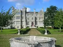 Fountain, approx. 50 Metres South of Ramsey Abbey | |
| Precinct Wall running along the Eastern and Southern Side of Church Green and along the Eastern and Southern Side of Abbey Green | Ramsey, Huntingdonshire | Wall | Medieval | 8 June 1983 | TL2914485125 52°26′56″N 0°06′04″W |
1130265 | Upload Photo |
| The Gables | Ramsey, Huntingdonshire | Hall House | Medieval | 8 June 1983 | TL2860384994 52°26′52″N 0°06′33″W |
1330454 | Upload Photo |
| Manor House | St Ives, Huntingdonshire | House | Late 16th century | 29 September 1951 | TL3127671189 52°19′23″N 0°04′31″W |
1128709 |  Manor House |
| New Bridges | Saint Ives, Huntingdonshire | Bridge | 1822 | 4 November 1982 | TL3116970977 52°19′16″N 0°04′37″W |
1163147 | 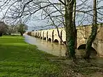 New Bridges |
| Manor House Farmhouse | Sawtry, Huntingdonshire | Farmhouse | Late 17th century | 21 July 1951 | TL1713182673 52°25′46″N 0°16′43″W |
1162796 | Upload Photo |
| Great North Road Bridge carrying North Bound Carriageway over the River Nene | Sibson-cum-Stibbington, Huntingdonshire | Road Bridge | 1925-8 | 14 October 1991 | TL0763099360 52°34′53″N 0°24′47″W |
1274340 | Upload Photo |
| Parish Church of St John the Baptist | Stibbington, Sibson-cum-Stibbington, Huntingdonshire | Parish Church | Early to mid 12th century | 13 December 1957 | TL0902398666 52°34′30″N 0°23′34″W |
1274862 | 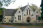 Parish Church of St John the Baptist |
| The Haycock Hotel | Wansford, Sibson-cum-Stibbington, Huntingdonshire | Hotel | 18th century | 25 September 1951 | TL0756499057 52°34′43″N 0°24′51″W |
1237866 | 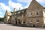 The Haycock Hotel |
| The Old Rectory | Stibbington, Sibson-cum-Stibbington, Huntingdonshire | Dairy | Early to mid 17th century | 25 September 1951 | TL0904198632 52°34′29″N 0°23′33″W |
1222331 | Upload Photo |
| The George | Spaldwick, Huntingdonshire | Inn | 16th century and 17th century | 21 July 1951 | TL1292272806 52°20′30″N 0°20′38″W |
1130204 | 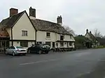 The George |
| The Limes | Spaldwick, Huntingdonshire | Farmhouse | Late 17th century | 21 July 1951 | TL1308072766 52°20′29″N 0°20′30″W |
1130203 | Upload Photo |
| Brook House | St Neots, Huntingdonshire | House | Early 18th century | 10 January 1951 | TL1837560172 52°13′37″N 0°16′06″W |
1309921 | Upload Photo |
| Crosshall | Eaton Socon, St. Neots, Huntingdonshire | Farmhouse | 17th century | 7 May 1952 | TL1741661201 52°14′11″N 0°16′55″W |
1331024 | Upload Photo |
| Ford House | Eaton Socon, St. Neots, Huntingdonshire | Box Frame House | Mid-late 15th century | 13 July 1964 | TL1765659978 52°13′32″N 0°16′44″W |
1128743 | Upload Photo |
| Parish Church of St Mary | Eynesbury, St. Neots, Huntingdonshire | Bell Tower | 1688 | 10 January 1951 | TL1838859836 52°13′26″N 0°16′06″W |
1127993 |  Parish Church of St Mary |
| Parish Church of St Mary | Eaton Socon, St. Neots, Huntingdonshire | Parish Church | C14-15 | 13 July 1964 | TL1704058869 52°12′56″N 0°17′18″W |
1127971 | 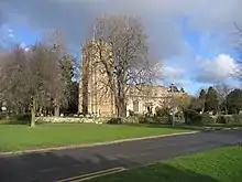 Parish Church of St Mary |
| Tudor House | Eynesbury, St. Neots, Huntingdonshire | House | Late 17th century | 10 January 1951 | TL1830059926 52°13′29″N 0°16′10″W |
1128739 | Upload Photo |
| Parish Church of St Mary | Stilton, Huntingdonshire | Parish Church | Earlier | 13 December 1957 | TL1595989264 52°29′20″N 0°17′37″W |
1215661 | 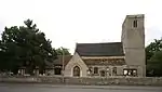 Parish Church of St Mary |
| The Bell Inn | Stilton, Huntingdonshire | House | 19th century | 25 September 1951 | TL1630389289 52°29′21″N 0°17′19″W |
1216001 | 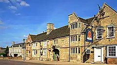 The Bell Inn |
| Church of St Botolph | Stow Longa, Huntingdonshire | Village Cross | Late 12th century | 14 May 1959 | TL1070171151 52°19′38″N 0°22′37″W |
1214736 | 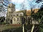 Church of St Botolph |
| Church of St Bartholomew | Great Stukeley, The Stukeleys, Huntingdonshire | Parish Church | 12th century | 28 January 1958 | TL2169774567 52°21′20″N 0°12′52″W |
1165400 | 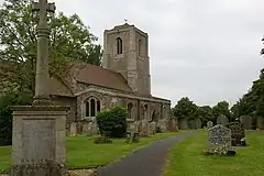 Church of St Bartholomew |
| Church of St Martin | Little Stukeley, The Stukeleys, Huntingdonshire | Parish Church | 12th century | 28 January 1958 | TL2094875684 52°21′57″N 0°13′30″W |
1130165 | 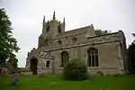 Church of St Martin |
| Hardened Aircraft Shelters | The Stukeleys, Huntingdonshire | Hardened Aircraft Shelter | Built c1983 | 10 September 2007 | TL2188077147 52°22′44″N 0°12′39″W |
1392250 | Upload Photo |
| The Avionics Building | The Stukeleys, Huntingdonshire | Engineering Workshop | Extant 1989-1995 | 10 September 2007 | TL2156676882 52°22′35″N 0°12′56″W |
1392251 | Upload Photo |
| Manor House | Tilbrook, Huntingdonshire | Timber Framed House | 17th century | 28 April 1983 | TL0815269516 52°18′47″N 0°24′54″W |
1288422 | Upload Photo |
| Parish Church of St Michael | Toseland, Huntingdonshire | Parish Church | 18th century | 14 May 1959 | TL2402162596 52°14′51″N 0°11′05″W |
1290027 | 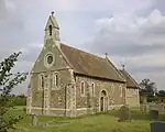 Parish Church of St Michael |
| Toseland Hall | Toseland, Huntingdonshire | Manor House | Early 17th century | 24 October 1951 | TL2351262575 52°14′51″N 0°11′32″W |
1211590 | 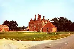 Toseland Hall |
| Church of St Margaret | Upton, Upton and Coppingford, Huntingdonshire | Parish Church | Late 11th century | 28 January 1958 | TL1744878506 52°23′31″N 0°16′32″W |
1130171 |  Church of St Margaret |
| Former St James Church | Little Raveley, Upwood and the Raveleys, Huntingdonshire | House | c. 1980 | 3 February 1987 | TL2559079947 52°24′11″N 0°09′19″W |
1130121 | 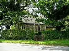 Former St James Church |
| The Old Barn | Upwood, Upwood and the Raveleys, Huntingdonshire | House | 16th century | 2 March 1987 | TL2584082793 52°25′43″N 0°09′02″W |
1162855 | Upload Photo |
| 28 Church Road | Warboys, Huntingdonshire | Kitchen | 17th century | 24 October 1951 | TL3023079891 52°24′06″N 0°05′14″W |
1128357 | Upload Photo |
| Church of St James the Great | Waresley-cum-Tetworth, Huntingdonshire | Parish Church | 1855-7 | 14 May 1959 | TL2495954548 52°10′30″N 0°10′27″W |
1289920 |  Church of St James the Great |
| Tetworth Hall at End of Lane from Dove Road to Tetworth Hall | Waresley-cum-Tetworth, Huntingdonshire | Country House | 1710 | 24 October 1951 | TL2176353054 52°09′44″N 0°13′17″W |
1290026 | 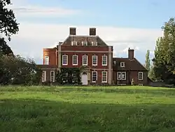 Tetworth Hall at End of Lane from Dove Road to Tetworth Hall |
| Parish Church of St Remigius | Water Newton, Huntingdonshire | Parish Church | 12th century | 13 December 1957 | TL1088397322 52°33′45″N 0°21′56″W |
1237953 | 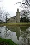 Parish Church of St Remigius |
| Parish Church of All Saints | Winwick, Huntingdonshire | Parish Church | 12th century | 28 January 1958 | TL1047480700 52°24′47″N 0°22′38″W |
1223069 | 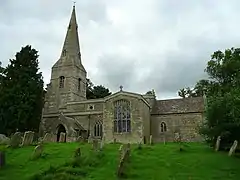 Parish Church of All Saints |
| Church of St Andrew | Wood Walton, Huntingdonshire | Parish Church | 13th century | 28 January 1958 | TL2088882168 52°25′27″N 0°13′25″W |
1130123 | |
| Church of St John the Baptist | Woodhurst, Huntingdonshire | Parish Church | Late 12th century | 30 May 1958 | TL3157576107 52°22′02″N 0°04′08″W |
1163919 | 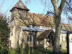 Church of St John the Baptist |
| Holdick Farmhouse | Woodhurst, Huntingdonshire | Farmhouse | Early 18th century | 30 May 1958 | TL3182675916 52°21′56″N 0°03′55″W |
1128376 | Upload Photo |
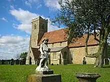
| Parish Church of the Holy Cross | Yelling, Huntingdonshire | Parish church | 1180-90 | 14 May 1959 | TL2622162468 52°14′45″N 0°09′10″W |
1211788 | 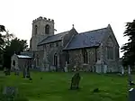 Parish Church of the Holy Cross |
.jpg.webp)
Notes
- The date given is the date used by Historic England as significant for the initial building or that of an important part in the structure's description.
- Sometimes known as OSGB36, the grid reference is based on the British national grid reference system used by the Ordnance Survey.
- The "List Entry Number" is a unique number assigned to each listed building and scheduled monument by Historic England.
External links
This article is issued from Wikipedia. The text is licensed under Creative Commons - Attribution - Sharealike. Additional terms may apply for the media files.