Grade II* listed buildings in King's Lynn and West Norfolk
There are over 20,000 Grade II* listed buildings in England. This page is a list of these buildings in the district of King's Lynn and West Norfolk in Norfolk.
King's Lynn and West Norfolk
| Name | Location | Type | Completed [note 1] | Date designated | Grid ref.[note 2] Geo-coordinates |
Entry number [note 3] | Image |
|---|---|---|---|---|---|---|---|
| Church of St. Mary | Anmer | Parish Church | 14th century | 5 June 1953 | TF7378829502 52°50′06″N 0°34′43″E |
1077863 |  Church of St. Mary |
| Church of All Saints | Barmer, Bagthorpe with Barmer | Parish Church | 12th century | 5 June 1953 | TF8091433624 52°52′11″N 0°41′11″E |
1077802 | 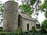 Church of All Saints |
| Ruins of Church of St Michael | Bawsey | Parish Church | 12th century | 19 October 1951 | TF6570019200 52°44′42″N 0°27′12″E |
1342379 |  Ruins of Church of St Michael |
| Church of All Saints | Bircham Newton, Bircham | Parish Church | Earlier | 5 June 1953 | TF7695033856 52°52′23″N 0°37′40″E |
1077805 | 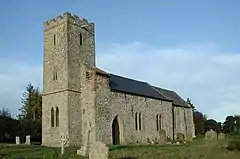 Church of All Saints |
| Church of All Saints | Boughton | Parish Church | Early 19th century | 8 July 1959 | TF6999302220 52°35′28″N 0°30′29″E |
1342335 |  Church of All Saints |
| Church of St Mary | Burnham Deepdale, Brancaster | Parish Church | 12th century | 5 June 1953 | TF8044644307 52°57′57″N 0°41′07″E |
1237969 | |
| Staithe House | Brancaster Staithe, Brancaster | Merchants House | Second quarter of 18th century | 5 June 1953 | TF7904244259 52°57′57″N 0°39′52″E |
1274478 |  Upload Photo |
| Burnham Westgate Hall | Burnham Market | Country House | pre 1783 | 5 June 1953 | TF8300442161 52°56′44″N 0°43′20″E |
1274350 | |
| Church of All Saints | Burnham Ulph, Burnham Market | Parish Church | pre 1200 | 5 June 1953 | TF8355042251 52°56′46″N 0°43′49″E |
1238876 | 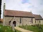 Church of All Saints |
| Market House and Lime Tree House | Burnham Market | House | 17th century | 5 June 1953 | TF8321642181 52°56′45″N 0°43′31″E |
1238590 | _The_Green%252C_Burnham_Market.jpg.webp) Market House and Lime Tree House |
| Detached Gable Wall, Friary Ruins | Burnham Norton | Carmelite Friary | 14th century | 5 June 1953 | TF8382642777 52°57′03″N 0°44′05″E |
1238878 | |
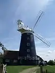
| Windmill | Burnham Overy Staithe, Burnham Overy | House | 1816 | 1 March 1985 | TF8377043751 52°57′35″N 0°44′04″E |
1273832 | |
| Tudor Lodgings and Attached Service Wing/cottage | Castle Acre | House | C20 | 15 August 1960 | TF8180714974 52°42′07″N 0°41′22″E |
1077685 | Upload Photo |
| Market Cross | Castle Rising | Market Cross | 15th century | 19 October 1951 | TF6654224860 52°47′44″N 0°28′07″E |
1342437 |  Market Cross |
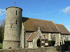
| Church of Saint Margaret | Clenchwarton | Parish Church | 14th century | 11 August 1951 | TF5894220210 52°45′22″N 0°21′14″E |
1237110 | 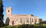 Church of Saint Margaret |
| Church of St Andrew | Congham | Parish Church | 13th century | 15 August 1960 | TF7128423660 52°47′00″N 0°32′18″E |
1342438 | 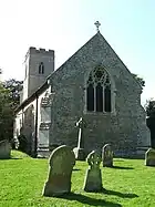 Church of St Andrew |
| Church of St Mary | Crimplesham | Parish Church | 12th century | 8 July 1959 | TF6553103729 52°36′22″N 0°26′35″E |
1077765 | 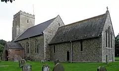 Church of St Mary |
| Church of St Mary | Denver | Parish Church | Late 13th century | 9 July 1951 | TF6145501646 52°35′19″N 0°22′55″E |
1342310 |  Church of St Mary |
| Denver Hall | Denver | House | c. 1520 | 9 July 1951 | TF6158301559 52°35′16″N 0°23′01″E |
1342309 | Upload Photo |
| Gatehouse 20 Metres North of Denver Hall | Denver | Coat of Arms | 1570 | 9 November 1984 | TF6158101576 52°35′17″N 0°23′01″E |
1077847 | Upload Photo |
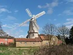
| Denver Windmill | Denver | Tower Mill | 1835 | 9 July 1951 | TF6050401211 52°35′06″N 0°22′04″E |
1077850 | |
| Church of St Mary the Virgin | Docking | Parish Church | 14th century | 5 June 1953 | TF7652736976 52°54′04″N 0°37′23″E |
1077811 | 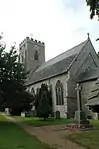 Church of St Mary the Virgin |
| Church of St Mary | East Rudham | Parish Church | 11th century | 5 June 1953 | TF8274228274 52°49′16″N 0°42′38″E |
1077780 | 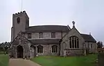 Church of St Mary |
| Remains of St Mary's Priory | Coxford, East Rudham | Augustinian Monastery | 13th century | 5 June 1953 | TF8481429021 52°49′37″N 0°44′30″E |
1152495 | 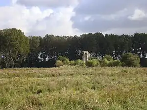 Remains of St Mary's Priory |
| Church of All Saints | East Winch | Parish Church | 14th century | 15 August 1960 | TF6909416257 52°43′03″N 0°30′07″E |
1342382 | 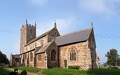 Church of All Saints |
| Church of St Cecilia | West Bilney, East Winch | Parish Church | 14th century | 15 August 1960 | TF7170315356 52°42′31″N 0°32′25″E |
1077671 | 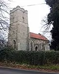 Church of St Cecilia |
| Fincham Hall | Fincham | Manor House | c. 1500 | 26 April 1985 | TF6944306500 52°37′47″N 0°30′08″E |
1152126 | 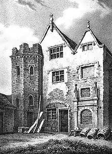 Fincham Hall |
| Church of St Mary | Flitcham, Flitcham with Appleton | Parish Church | 11th century | 15 August 1960 | TF7250626627 52°48′35″N 0°33′29″E |
1168565 | 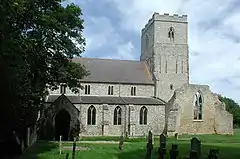 Church of St Mary |
| Church of St Mary | Fordham | Parish Church | Late 13th century | 9 July 1951 | TL6165799640 52°34′14″N 0°23′02″E |
1205531 | |
| Snore Hall | Fordham | House | Mid 15th century | 9 July 1951 | TL6239899316 52°34′03″N 0°23′41″E |
1280674 | Upload Photo |
| Church of All Saints | Fring | Parish Church | 14th century | 5 June 1953 | TF7354134868 52°53′00″N 0°34′40″E |
1304672 | 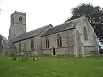 Church of All Saints |
| Church of All Saints | Hilgay | Parish Church | Early 13th century | 8 July 1959 | TL6225498114 52°33′24″N 0°23′31″E |
1077719 | 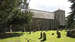 Church of All Saints |
| Wood Hall | Hilgay | House | 1579 | 9 July 1951 | TL6294497481 52°33′03″N 0°24′07″E |
1077724 | 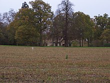 Wood Hall |
| Church of St Mary | Hillington | Parish Church | 15th century | 15 August 1960 | TF7231825221 52°47′49″N 0°33′16″E |
1306957 | 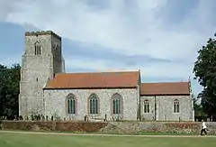 Church of St Mary |
| Village Cross | Hockwold cum Wilton | Village Cross | Early 14th century | 8 July 1959 | TL7346488007 52°27′45″N 0°33′07″E |
1306861 | 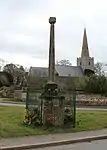 Village Cross |
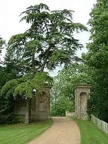
| Houghton Hall South Lodges with Gates, Gate Piers and Walls attached | New Houghton, Houghton | Gate Lodge | c. 1730 | 9 October 1985 | TF7908227789 52°49′04″N 0°39′22″E |
1153105 | 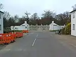 Houghton Hall South Lodges with Gates, Gate Piers and Walls attached |
| Smithdon High School including Main Block Water Tower Workshops and Kitchens | Hunstanton | School | 1950-1954 | 30 March 1993 | TF6786740573 52°56′11″N 0°29′47″E |
1077909 | 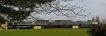 Smithdon High School including Main Block Water Tower Workshops and Kitchens |
| Gymnasium at Smithdon High School | Hunstanton | Gymnasium | Post 1954 | 30 March 1993 | TF6780640536 52°56′10″N 0°29′44″E |
1342261 | Upload Photo |
| Church of All Saints and Saint Michael | Ingoldisthorpe | Parish Church | 14th century | 5 June 1953 | TF6906932756 52°51′57″N 0°30′37″E |
1342280 | 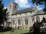 Church of All Saints and Saint Michael |
| Ingoldisthorpe Hall | Ingoldisthorpe | Country House | 1757 | 5 June 1953 | TF6875232537 52°51′50″N 0°30′19″E |
1077868 | Upload Photo |
| Church of All Saints | Ashwicken, Leziate | Parish Church | 13th century | 15 August 1960 | TF6983718841 52°44′26″N 0°30′52″E |
1077644 | 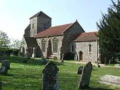 Church of All Saints |
| Remains of Abbey of SS. Mary, Barbara and Edmund | Marham | Abbey | 1249 | 8 July 1959 | TF7072109810 52°39′33″N 0°31′22″E |
1304912 | Upload Photo |
| Church of St Mary | Middleton | Parish Church | 13th century | 15 August 1960 | TF6626815989 52°42′58″N 0°27′36″E |
1077646 | 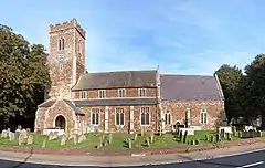 Church of St Mary |
| Village Cross | Northwold | Village Cross | Late 14th century | 8 July 1959 | TL7496897336 52°32′45″N 0°34′44″E |
1306081 | Upload Photo |
| Chapel of St Andrew | Barret Ringstead, Old Hunstanton | Chapel ruin | 13th century | 5 June 1953 | TF6836839938 52°55′50″N 0°30′13″E |
1077919 | .jpg.webp) Chapel of St Andrew |
| The Octagon | Hunstanton Park, Old Hunstanton | Garden Building | c. 1640 | 5 June 1953 | TF6917441631 52°56′43″N 0°30′59″E |
1171881 | Upload Photo |
| Church of St Andrew | Ringstead | Parish Church | c. 1300 | 5 June 1953 | TF7057840669 52°56′11″N 0°32′12″E |
1171984 | 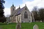 Church of St Andrew |
| Church of All Saints | Roydon | Parish Church | 13th century | 15 August 1960 | TF6991323656 52°47′01″N 0°31′05″E |
1077627 | 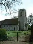 Church of All Saints |
| Church of St Andrew | South Runcton, Runcton Holme | Parish Church | Early 12th century | 8 July 1959 | TF6352208938 52°39′13″N 0°24′58″E |
1342289 | .jpg.webp) Church of St Andrew |
| Church of St Michael | Ryston | Parish Church | 12th century | 9 July 1951 | TF6209501756 52°35′22″N 0°23′29″E |
1077857 | 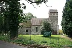 Church of St Michael |
| Ryston Hall | Ryston | Country House | 1669-72 | 9 July 1951 | TF6254801148 52°35′02″N 0°23′52″E |
1205569 | |
| Church of St Mary the Virgin | Bexwell, Ryston | Parish Church | 14th century | 9 July 1951 | TF6314003409 52°36′14″N 0°24′27″E |
1077855 | 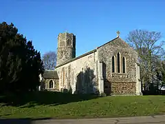 Church of St Mary the Virgin |
| Church of St Mary Magdalene | Sandringham | Parish Church | Medieval | 15 August 1960 | TF6911928592 52°49′42″N 0°30′32″E |
1077615 | |
| Church of St Peter | Wolferton, Sandringham | Parish Church | c. 1300 | 15 August 1960 | TF6571928180 52°49′32″N 0°27′29″E |
1077588 | 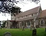 Church of St Peter |
| Church of St Peter and St Paul | West Newton, Sandringham | Parish Church | Medieval | 15 August 1960 | TF6962327590 52°49′09″N 0°30′57″E |
1342429 |  Church of St Peter and St Paul |
| Wolferton railway station down side | Wolferton, Sandringham | House | 1988 | 2 September 1988 | TF6605128541 52°49′44″N 0°27′48″E |
1077593 | 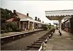 Wolferton railway station down side |
| Wolferton railway station Gates, Piers and Railings to down side | Wolferton, Sandringham | Gate | c. 1898 | 2 September 1988 | TF6600228540 52°49′44″N 0°27′45″E |
1168875 |  Wolferton railway station Gates, Piers and Railings to down side |
| Wolferton Station Goods Office circa 10 Metres North East of down side | Wolferton, Sandringham | Railway Office | 1898 | 2 September 1988 | TF6608028568 52°49′45″N 0°27′49″E |
1342433 | Upload Photo |
| Wolferton Station Signal Box | Wolferton, Sandringham | Signal Box | 1862 | 2 September 1988 | TF6600028507 52°49′43″N 0°27′45″E |
1077592 | 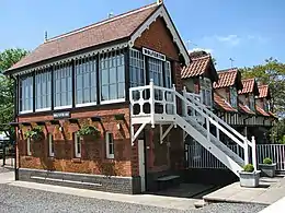 Wolferton Station Signal Box |
| Church of Saint Peter and Saint Paul | Shernborne | Parish Church | 11th century | 5 June 1953 | TF7137732428 52°51′43″N 0°32′39″E |
1153045 | .jpg.webp) Church of Saint Peter and Saint Paul |
| Church of St Mary the Virgin | Shouldham Thorpe | Parish Church | Early 12th century | 8 July 1959 | TF6611708009 52°38′40″N 0°27′14″E |
1152535 | 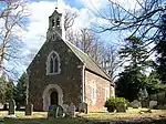 Church of St Mary the Virgin |
| Ken Hill | Ken Hill, Snettisham | House | 1878-9 | 15 October 1981 | TF6753534938 52°53′09″N 0°29′19″E |
1077874 | Upload Photo |
| Snettisham Old Hall | Snettisham | Country House | 18th century | 5 June 1953 | TF6850834346 52°52′49″N 0°30′10″E |
1153140 | Upload Photo |
| The Mill | Southgate, Snettisham | Watermill | 1800 | 16 May 1977 | TF6808533469 52°52′21″N 0°29′45″E |
1077845 |  The Mill |
| Barns, Stables and Attached Outbuildings at Waterden Farm | Waterden, South Creake | Oxhouse | 1700-1871 | 15 November 1999 | TF8869036108 52°53′22″N 0°48′12″E |
1379645 | Upload Photo |
| Church of All Saints | Waterden, South Creake | Parish Church | Anglo Saxon | 5 June 1953 | TF8847935804 52°53′12″N 0°48′00″E |
1077758 | 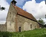 Church of All Saints |
| Church of St Mary | South Wootton | Parish Church | Medieval | 15 August 1960 | TF6403522752 52°46′39″N 0°25′50″E |
1077597 | 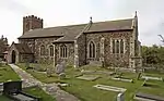 Church of St Mary |
| Stoke Ferry Hall | Stoke Ferry | House | 1792 | 9 July 1951 | TL7039999912 52°34′13″N 0°30′46″E |
1077744 | .jpg.webp) Stoke Ferry Hall |
| Church of St Mary | Stradsett | Parish Church | 13th century | 8 July 1959 | TF6682105684 52°37′24″N 0°27′47″E |
1342301 | 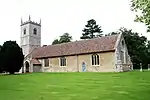 Church of St Mary |
| Lovells Hall | Terrington St. Clement | House | 1543 | 11 August 1951 | TF5494519552 52°45′05″N 0°17′39″E |
1237117 | Upload Photo |
| Thornham Hall | Thornham | House | c. 1780 | 5 June 1953 | TF7343643174 52°57′28″N 0°34′50″E |
1342297 | Upload Photo |
| Church of Saint Mary | Islington, Tilney St. Lawrence | Church ruin | Late 13th century | 11 August 1951 | TF5708316888 52°43′37″N 0°19′29″E |
1264178 | 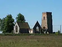 Church of Saint Mary |
| Church of St Lawrence | Tilney St. Lawrence | Parish Church | 14th century | 11 August 1951 | TF5496514860 52°42′33″N 0°17′33″E |
1237259 | .jpg.webp) Church of St Lawrence |
| Village Cross | Titchwell | Village Cross | Mediaeval | 5 June 1953 | TF7623743721 52°57′43″N 0°37′21″E |
1273642 | 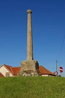 Village Cross |
| Crescent House | Upwell | House | c1620-40 | 18 January 1978 | TF5027802762 52°36′07″N 0°13′03″E |
1125935 | Upload Photo |
| The Cottages East of Lloyds Bank | Upwell | House | 19th century | 31 October 1983 | TF5045502774 52°36′07″N 0°13′13″E |
1161209 | Upload Photo |
| Welle Manor Hall | New Road, Upwell | Manor House | Mid 14th century | 11 August 1951 | TF5060502717 52°36′05″N 0°13′20″E |
1171599 | Upload Photo |
| Old Manor Farmhouse | The Chase, Walpole | Farmhouse | 1638 | 11 August 1951 | TF5021717041 52°43′49″N 0°13′23″E |
1237330 | Upload Photo |
| Church of St Mary the Virgin | Welney | Parish Church | 1848 | 6 February 1986 | TL5262293850 52°31′16″N 0°14′53″E |
1168946 | 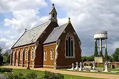 Church of St Mary the Virgin |
| Church of St Margaret of Antioch | Wereham | Church | Early 13th century | 5 July 1959 | TF6810301667 52°35′13″N 0°28′48″E |
1342376 | 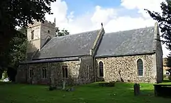 Church of St Margaret of Antioch |
| Barn 100 Metres South West of Abbey Farmhouse with Detached Gable 10 Metres to North | West Acre | Barn | Late Medieval | 19 October 1951 | TF7803015051 52°42′14″N 0°38′01″E |
1171759 | Upload Photo |
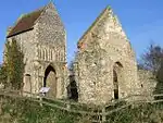
| Remains of Base of South West Tower and Part of West Claustral Range of West Acre Priory, 20 Metres East of Abbey Farm House | West Acre | Tower | 12th century | 19 October 1951 | TF7814915140 52°42′17″N 0°38′07″E |
1077661 |  Remains of Base of South West Tower and Part of West Claustral Range of West Acre Priory, 20 Metres East of Abbey Farm House |
| Gatepiers at North East Corner of Abbey Precinct | West Dereham | Gate Pier | 1697 | 9 July 1951 | TF6629800842 52°34′48″N 0°27′11″E |
1342341 | |
| Ruins of Service Wing of West Dereham Abbey House | West Dereham | Stable | 1697 | 9 July 1951 | TF6611600498 52°34′37″N 0°27′00″E |
1170628 | Upload Photo |
| Ruins of West Dereham Abbey House | West Dereham | House | 1697 | 9 July 1951 | TF6612600630 52°34′41″N 0°27′01″E |
1077755 | Upload Photo |
| Church of St Mary | West Winch | Church | 1766 | 15 August 1960 | TF6322115865 52°42′57″N 0°24′54″E |
1342420 | 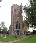 Church of St Mary |
| Fitton Oake | Wiggenhall St. Germans | House | 1570-77 | 9 July 1951 | TF5943013490 52°41′44″N 0°21′28″E |
1077894 | Upload Photo |
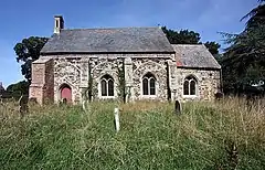
| Ruins of Church of St Peter | Wiggenhall St. Germans | Parish Church | 15th century | 8 July 1959 | TF6043413252 52°41′35″N 0°22′21″E |
1152777 | .jpg.webp) Ruins of Church of St Peter |
| St Germans Hall | Wiggenhall St. Germans | House | Mid 17th century | 9 July 1951 | TF5936614194 52°42′07″N 0°21′26″E |
1304623 | .jpg.webp) St Germans Hall |
| St Marys Hall | Wiggenhall St. Germans | House | 1864 | 9 July 1951 | TF5847114475 52°42′17″N 0°20′39″E |
1304598 | Upload Photo |
| The Priory | Wiggenhall St. Mary Magdalen | House | late C20 | 9 July 1951 | TF5999811451 52°40′38″N 0°21′55″E |
1152801 | Upload Photo |
| Church of St Mary | Wimbotsham | Church | 1525 | 9 July 1951 | TF6223704892 52°37′03″N 0°23′42″E |
1205605 |  Church of St Mary |
| Church of St Michael | Wormegay | Parish Church | 13th century | 8 July 1959 | TF6741712027 52°40′48″N 0°28′30″E |
1077839 | 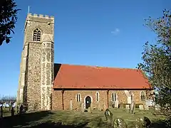 Church of St Michael |
| Church of All Saints | Wretton | Parish Church | Late 13th century | 11 December 1985 | TL6903499909 52°34′15″N 0°29′34″E |
1342342 | 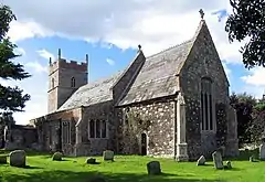 Church of All Saints |
| Bank House | King's Lynn | Toll House | 16th century | 1 December 1951 | TF6160419948 52°45′11″N 0°23′35″E |
1220654 | Upload Photo |
| Bishop's Lynn House | King's Lynn | House | Late C14/Early 15th century | 1 December 1951 | TF6164820361 52°45′24″N 0°23′38″E |
1289527 | Upload Photo |
| Burnham House and Attached Walls | King's Lynn | House | 19th century | 1 December 1951 | TF6175519709 52°45′03″N 0°23′43″E |
1195435 | Upload Photo |
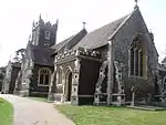
| Church of All Saints | King's Lynn | Parish Church | 11th century | 1 December 1951 | TF6204019570 52°44′58″N 0°23′58″E |
1195345 | .jpg.webp) Church of All Saints |
| Church of St Faith | Gaywood | Parish Church | Norman | 1 December 1951 | TF6361520396 52°45′23″N 0°25′23″E |
1195311 | .jpg.webp) Church of St Faith |
| Church of St Peter | West Lynn | Parish Church | Norman | 1 December 1951 | TF6121019736 52°45′04″N 0°23′14″E |
1290105 | 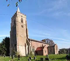 Church of St Peter |
| Cross beneath Greyfriars Tower | King's Lynn | Cross | C9-C10 | 26 July 1993 | TF6201219783 52°45′05″N 0°23′56″E |
1290255 | 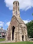 Cross beneath Greyfriars Tower |
| Gaolhouse | King's Lynn | Prison | 1784 | 1 December 1951 | TF6172919860 52°45′08″N 0°23′42″E |
1195399 | .jpg.webp) Gaolhouse |
| Greenland Fishery House | King's Lynn | Jettied House | 1605-8 | 1 December 1951 | TF6188219623 52°45′00″N 0°23′49″E |
1219470 | 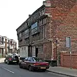 Greenland Fishery House |
| Health Centre 5m South West of Nos 7 and 9 King Street | King's Lynn | Warehouse | 15th century | 9 December 1988 | TF6159220086 52°45′15″N 0°23′35″E |
1220209 | .jpg.webp) Health Centre 5m South West of Nos 7 and 9 King Street |
| King Edward VII High School | King's Lynn | Grammar School | 1906 | 7 June 1972 | TF6297420417 52°45′24″N 0°24′49″E |
1195312 | Upload Photo |
| Lattice House | King's Lynn | House | Occupied by 1487 | 1 December 1951 | TF6181720328 52°45′23″N 0°23′47″E |
1291415 | 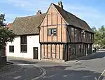 Lattice House |
| Length of Town Wall | King's Lynn | Town Gate | 1266 | 1 December 1951 | TF6237220264 52°45′20″N 0°24′17″E |
1220776 | Upload Photo |
| Length of Town Wall | King's Lynn | Town Wall | 1266 | 1 December 1951 | TF6231720460 52°45′27″N 0°24′14″E |
1298197 | Upload Photo |
| Marriott's Warehouse | King's Lynn | Warehouse | Early 14th century | 1 December 1951 | TF6165619761 52°45′05″N 0°23′37″E |
1212000 | 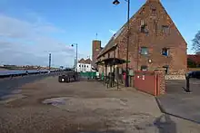 Marriott's Warehouse |
| Medieval Merchant's House | 7-9 King Street, King's Lynn | Apartment | C20 | 1 December 1951 | TF6162020096 52°45′16″N 0°23′36″E |
1291131 | Upload Photo |
| Museum of Social History | 27 King Street, King's Lynn | House | Early 19th century | 1 December 1951 | TF6163020208 52°45′19″N 0°23′37″E |
1298222 | Museum of Social History |
| North Guannock Gate and Portion of Town Wall | King's Lynn | Town Gate | Late 13th century | 1 December 1951 | TF6246019731 52°45′03″N 0°24′20″E |
1219520 |  North Guannock Gate and Portion of Town Wall |
| Northern Gateway to Carmelite Precinct | King's Lynn | Gate | 15th century | 1 December 1951 | TF6188019500 52°44′56″N 0°23′49″E |
1212056 | .jpg.webp) Northern Gateway to Carmelite Precinct |
| Oxley House | King's Lynn | House | Late 17th century | 1 December 1951 | TF6179119672 52°45′02″N 0°23′45″E |
1298134 | Upload Photo |
| Tudor Rose Hotel | King's Lynn | House | 16th century | 1 December 1951 | TF6176620413 52°45′26″N 0°23′44″E |
1298153 | .jpg.webp) Tudor Rose Hotel |
| 1-3 Purfleet Place | King's Lynn | Terrace | c. 1825 | 1 December 1951 | TF6163120001 52°45′12″N 0°23′37″E |
1195413 | Upload Photo |
| 12–20 Priory Lane | King's Lynn | Benedictine Monastery | 14th century | 1 December 1951 | TF6177919758 52°45′04″N 0°23′44″E |
1195412 | Upload Photo |
| 1, St Margaret's Place | King's Lynn | House | Late 15th century | 7 June 1972 | TF6169619829 52°45′07″N 0°23′40″E |
1195390 | Upload Photo |
| 2, St Margaret's Place | King's Lynn | House | Early 18th century | 1 December 1951 | TF6170419808 52°45′06″N 0°23′40″E |
1195391 | Upload Photo |
| 30 & 32 Pilot Street | King's Lynn | House | 19th century | 1 December 1951 | TF6192420482 52°45′28″N 0°23′53″E |
1195408 | Upload Photo |
| 15 & 16 Tuesday Market Place | King's Lynn | House | Early 16th century | 1 December 1951 | TF6168120388 52°45′25″N 0°23′40″E |
1212298 | Upload Photo |
| 17 & 18 Church Street | King's Lynn | House | C20 | 7 June 1972 | TF6181819761 52°45′04″N 0°23′46″E |
1219670 | Upload Photo |
| 5 King Street | King's Lynn | House | Mid 18th century | 1 December 1951 | TF6162120084 52°45′15″N 0°23′36″E |
1220161 | Upload Photo |
| 15 King Street | King's Lynn | House | Mid 18th century | 1 December 1951 | TF6162020141 52°45′17″N 0°23′36″E |
1195285 | Upload Photo |
| 15a King Street | King's Lynn | House | Early 16th century | 1 December 1951 | TF6162020128 52°45′17″N 0°23′36″E |
1298219 | Upload Photo |
| 25 Queen Street | King's Lynn | House | Mid 18th century | 1 December 1951 | TF6165219886 52°45′09″N 0°23′37″E |
1210409 | Upload Photo |
| 29a & 29b Queen Street | King's Lynn | House | Early 17th century | 1 December 1951 | TF6165919864 52°45′08″N 0°23′38″E |
1290483 | Upload Photo |
| 2a, 2b, 2c, St Ann's Street | King's Lynn | Shops | 1993 | 1 December 1951 | TF6181520540 52°45′30″N 0°23′47″E |
1210489 | 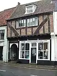 2a, 2b, 2c, St Ann's Street |
| 4 & 6 St Ann's Street | King's Lynn | House | C20 | 1 December 1951 | TF6181220532 52°45′29″N 0°23′47″E |
1298127 | Upload Photo |
| 2 Nelson Street | King's Lynn | House | 1993 | 1 December 1951 | TF6174519746 52°45′04″N 0°23′42″E |
1195431 | Upload Photo |
| 9 Nelson Street | King's Lynn | House | 1703 | 1 December 1951 | TF6174619722 52°45′03″N 0°23′42″E |
1195434 | Upload Photo |
| 15 & 17 Nelson Street | King's Lynn | House | 17th century | 1 December 1951 | TF6177619686 52°45′02″N 0°23′44″E |
1221095 | Upload Photo |
| 81, 81a, 81b High Street | King's Lynn | Shop | Early 17th century | 1 December 1951 | TF6172920159 52°45′17″N 0°23′42″E |
1195317 | Upload Photo |

.jpg.webp)
Notes
- The date given is the date used by Historic England as significant for the initial building or that of an important part in the structure's description.
- Sometimes known as OSGB36, the grid reference is based on the British national grid reference system used by the Ordnance Survey.
- The "List Entry Number" is a unique number assigned to each listed building and scheduled monument by Historic England.
External links
This article is issued from Wikipedia. The text is licensed under Creative Commons - Attribution - Sharealike. Additional terms may apply for the media files.