Grade II* listed buildings in Maldon (district)
There are over 20,000 Grade II* listed buildings in England. This page is a list of these buildings in the district of Maldon in Essex.
Maldon
| Name | Location | Type | Completed [note 1] | Date designated | Grid ref.[note 2] Geo-coordinates |
Entry number [note 3] | Image |
|---|---|---|---|---|---|---|---|
| Parish Church of St Andrew | Althorne, Maldon | Parish Church | Late 14th century | 1 November 1953 | TQ9090398926 51°39′24″N 0°45′31″E |
1110862 | 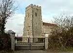 Parish Church of St Andrew |
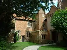
| Bradwell Hall | Bradwell-on-Sea, Maldon | House | 14th century | 10 January 1953 | TL9887505386 51°42′43″N 0°52′38″E |
1147175 |  Upload Photo |
| Bradwell Lodge | Bradwell-on-Sea, Maldon | Country House | c. 1785 | 10 January 1953 | TM0048806758 51°43′25″N 0°54′05″E |
1337401 | |
| Church of St Thomas | Bradwell-on-Sea, Maldon | Parish Church | 14th century | 30 December 1959 | TM0041606840 51°43′28″N 0°54′01″E |
1308856 | 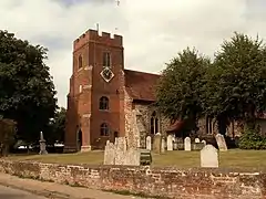 Church of St Thomas |
| Church of St Mary the Virgin | Burnham-on-Crouch, Maldon | Church | 1733 | 10 November 1951 | TQ9486797034 51°38′18″N 0°48′53″E |
1123763 | |
| Creeksea Place | Creeksea, Burnham-on-Crouch, Maldon | House | 16th century by 1569 | 10 November 1951 | TQ9344996163 51°37′52″N 0°47′37″E |
1123776 | |
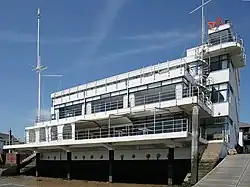
| Royal Corinthian Yacht Club | Burnham-on-Crouch, Maldon | Sailing Club | 1930 | 28 January 1971 | TQ9543195416 51°37′25″N 0°49′19″E |
1123772 | |
| Stow Maries WWI Airfield | Cold Norton, Maldon | Military Airfield | First World War | 26 April 2012 | TL8193300209 51°40′16″N 0°37′47″E |
1406155 | 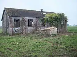 Stow Maries WWI Airfield |
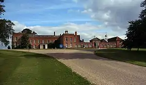
| Braxted Park | Great Braxted, Maldon | Country House | 17th century | 30 December 1959 | TL8549915344 51°48′21″N 0°41′21″E |
1111110 | |
| Cave/Icehouse situated at North Western End of the Lake | Braxted Park, Great Braxted, Maldon | Game Larder | C18/C19 | 8 August 1985 | TL8508815647 51°48′32″N 0°41′00″E |
1111072 | Upload Photo |
| Church of All Saints | Great Braxted, Maldon | Church | 12th century | 30 December 1959 | TL8509415439 51°48′25″N 0°41′00″E |
1165777 | 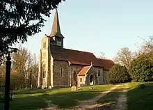 Church of All Saints |
| Tiptree Priory | Great Braxted, Maldon | Priory/House | c. 1570 | 7 May 1985 | TL8754214571 51°47′54″N 0°43′06″E |
1166055 | |
| Church of St Peter | Great Totham, Maldon | Parish Church | 13th century or 14th century | 30 December 1959 | TL8619811021 51°46′01″N 0°41′49″E |
1111050 | 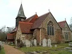 Church of St Peter |
| Great Ruffins | Beacon Hill, Great Totham, Maldon | House | c. 1904 | 8 August 1985 | TL8520912666 51°46′55″N 0°41′01″E |
1111087 | Upload Photo |
| Mountains and Garden Wall attached to right | Great Totham, Maldon | Timber Framed House | C15/C16 | 8 August 1985 | TL8618112891 51°47′01″N 0°41′52″E |
1337335 | Upload Photo |
| Church of St Giles | Langford, Maldon | Parish Church | C11/C12 | 30 December 1959 | TL8377309020 51°44′59″N 0°39′39″E |
1166011 | 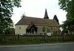 Church of St Giles |
| Kitchen/dovecote, approximately 100 Metres North of Little Braxted Hall | Little Braxted, Maldon | Kitchen | 15th century | 30 December 1959 | TL8353514808 51°48′06″N 0°39′38″E |
1146757 | Upload Photo |
| Beeleigh Steam Mill and Bridge over Tail Race | Beeleigh, Maldon | Steam Mill and Bridge | Early 19th century | 24 September 1971 | TL8396908192 51°44′32″N 0°39′48″E |
1257130 | 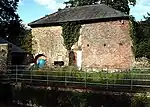 Beeleigh Steam Mill and Bridge over Tail Race |
| Blue Boar Hotel | Maldon | House | Mid 19th century | 2 October 1951 | TL8490607084 51°43′55″N 0°40′34″E |
1256381 | 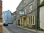 Blue Boar Hotel |
| Chandlers | Maldon | House | 17th century extension | 24 September 1971 | TL8493907110 51°43′56″N 0°40′36″E |
1256387 | Upload Photo |
| No 2, London Road with Raised Forecourt and Boundary Walls | Maldon | House | Mid to late 18th century | 2 October 1951 | TL8478207028 51°43′53″N 0°40′28″E |
1256575 | Upload Photo |
| Swan Hotel | Maldon | Hall House | Late 14th century | 2 October 1951 | TL8517807020 51°43′53″N 0°40′48″E |
1256847 | 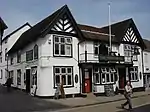 Swan Hotel |
| Talbots | Maldon | House | Late 16th century or early 17th century | 24 September 1971 | TL8477907003 51°43′53″N 0°40′28″E |
1256578 | Upload Photo |
| The Old Custom House | Maldon | House | Early 18th century | 2 October 1951 | TL8505507274 51°44′01″N 0°40′43″E |
1256548 | Upload Photo |
| Vicarage of Church of All Saints | Maldon | Jettied House | Early 16th century to mid 16th century | 24 September 1971 | TL8496407114 51°43′56″N 0°40′37″E |
1257084 | 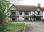 Vicarage of Church of All Saints |
| 1, 3 and 3a High Street | Maldon | Apartment | C20 | 4 August 1971 | TL8483007022 51°43′53″N 0°40′30″E |
1256956 | Upload Photo |
| 69 and 71 High Street | Maldon | Jettied House | 16th century | 2 October 1951 | TL8515307029 51°43′53″N 0°40′47″E |
1256844 | .jpg.webp) 69 and 71 High Street |
| 90, 92 and 94 High Street | Maldon | Open Hall House | 15th century | 24 September 1971 | TL8517106992 51°43′52″N 0°40′48″E |
1256860 | Upload Photo |
| 160, 160a, 162, 164 High Street | Maldon | Shops | C20 | 24 September 1971 | TL8546406832 51°43′46″N 0°41′03″E |
1256809 | .jpg.webp) 160, 160a, 162, 164 High Street |
| White House Farmhouse | Mundon | Farmhouse | c. 1570 | 30 May 1986 | TL8767503683 51°42′02″N 0°42′52″E |
1168535 | 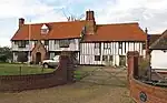 White House Farmhouse |
| Church of St Leonard | Southminster, Maldon | Parish Church | 12th century | 30 December 1959 | TQ9585199696 51°39′43″N 0°49′49″E |
1264082 | 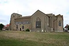 Church of St Leonard |
| Parish Church of St Mary | Stow Maries, Maldon | Parish Church | 14th century | 1 November 1953 | TQ8336299386 51°39′48″N 0°38′59″E |
1337436 | 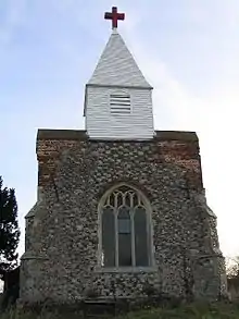 Parish Church of St Mary |
| Church of St Nicholas | Tillingham, Maldon | Parish Church | 12th century | 30 December 1959 | TL9932503831 51°41′52″N 0°52′58″E |
1247743 | 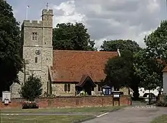 Church of St Nicholas |
| Stows Farmhouse | Tillingham, Maldon | Jettied House | 15th century | 5 August 1986 | TL9883603572 51°41′44″N 0°52′32″E |
1247749 | Upload Photo |
| Bourchier's Hall | Tollesbury, Maldon | House | 16th century | 10 January 1953 | TL9443011658 51°46′11″N 0°48′59″E |
1141665 | Upload Photo |
| Church of St Mary the Virgin | Tollesbury, Maldon | Parish Church | Late 11th century | 30 December 1959 | TL9563910370 51°45′28″N 0°50′00″E |
1328624 | 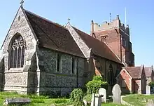 Church of St Mary the Virgin |
| Tollesbury Hall | Tollesbury, Maldon | Cross Wing House | Before 15th century | 10 January 1953 | TL9565110341 51°45′27″N 0°50′00″E |
1141670 | Upload Photo |
| Tolleshunt D'Arcy Hall | Tolleshunt D'Arcy, Maldon | House | Late 17th century | 10 January 1953 | TL9283711614 51°46′12″N 0°47′36″E |
1142513 | Upload Photo |
| Bridge over Moat, 12 Metres South of Tolleshunt D'Arcy Hall | Tolleshunt D'Arcy, Maldon | Moat | 1585 | 10 January 1953 | TL9282011584 51°46′11″N 0°47′35″E |
1142514 | Upload Photo |
| Dovecote approx. 35 Metres North East of Tolleshunt D'Arcy Hall | Tolleshunt D'Arcy, Maldon | Dovecote | Late 16th century | 10 January 1953 | TL9285411649 51°46′13″N 0°47′37″E |
1323172 | Upload Photo |
| Church of All Saints | Tolleshunt Knights, Maldon | Parish Church | 12th century | 30 December 1959 | TL9269513863 51°47′25″N 0°47′33″E |
1121938 | 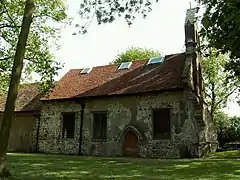 Church of All Saints |
| Gatehouse 40 Metres West of Beckingham Hall | Tolleshunt Major, Maldon | Courtyard | 1543-6 | 30 December 1959 | TL9093411252 51°46′03″N 0°45′56″E |
1142526 | 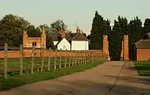 Gatehouse 40 Metres West of Beckingham Hall |
| Highams Farmhouse | Tolleshunt Major, Maldon | Dairy | 18th century | 5 February 1987 | TL9119509344 51°45′01″N 0°46′06″E |
1337678 | Upload Photo |
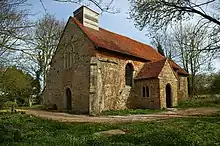
| Church of All Saints | Ulting, Maldon | Parish Church | 13th century | 30 December 1959 | TL8013408767 51°44′55″N 0°36′29″E |
1111002 | 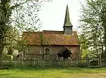 Church of All Saints |
| Ulting Hall | Ulting, Maldon | Manor House | Late 18th century or early 19th century | 10 January 1953 | TL8111409104 51°45′05″N 0°37′21″E |
1337355 | Upload Photo |
| Blue Mills | Wickham Hill, Wickham Bishops, Maldon | Watermill | Early 19th century | 1 March 1950 | TL8305713140 51°47′13″N 0°39′10″E |
1122562 | .jpg.webp) Blue Mills |
| Church of St Peter | Wickham Bishops, Maldon | Parish Church | Disused | 14 November 1985 | TL8248811207 51°46′11″N 0°38′36″E |
1111019 | |
| Mathyns | Wickham Hill, Wickham Bishops, Maldon | House | 1950 | 1 March 1950 | TL8308013134 51°47′13″N 0°39′11″E |
1169879 | Upload Photo |
| Wickham Place | Wickham Bishops, Maldon | House | Later extensions | 30 November 1959 | TL8232411755 51°46′29″N 0°38′29″E |
1337357 | Upload Photo |
| Nursery Farmhouse | Woodham Mortimer, Maldon | House | Early 18th century | 30 December 1959 | TL8122204380 51°42′32″N 0°37′18″E |
1146691 | Upload Photo |
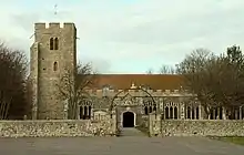
| Church of St Michael | Woodham Walter, Maldon | Bell Tower | 19th century | 30 December 1959 | TL8089506707 51°43′48″N 0°37′05″E |
1110960 | 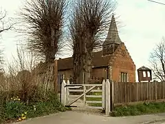 Church of St Michael |
| West Bowers Hall | Woodham Walter, Maldon | House | Later | 10 January 1953 | TL7979407686 51°44′21″N 0°36′09″E |
1308604 | .jpg.webp) West Bowers Hall |
.jpg.webp)

Notes
- The date given is the date used by Historic England as significant for the initial building or that of an important part in the structure's description.
- Sometimes known as OSGB36, the grid reference is based on the British national grid reference system used by the Ordnance Survey.
- The "List Entry Number" is a unique number assigned to each listed building and scheduled monument by Historic England.
External links
This article is issued from Wikipedia. The text is licensed under Creative Commons - Attribution - Sharealike. Additional terms may apply for the media files.