Grade II* listed buildings in Tendring
There are over 20,000 Grade II* listed buildings in England. This page is a list of these buildings in the district of Tendring in Essex.
Tendring
| Name | Location | Type | Completed [note 1] | Date designated | Grid ref.[note 2] Geo-coordinates |
Entry number [note 3] | Image |
|---|---|---|---|---|---|---|---|
| The Quarters | Alresford Park, Alresford, Tendring | House | c. 1951 | 21 February 1950 | TM0721520124 51°50′29″N 1°00′24″E |
1337178 |  Upload Photo |
| Church of St Mary | Ardleigh, Tendring | Parish Church | 14th century | 17 November 1966 | TM0539129550 51°55′36″N 0°59′09″E |
1112060 | 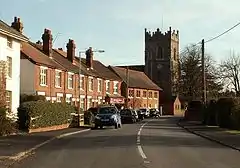 Church of St Mary |
| Spring Valley Mill | Ardleigh, Tendring | Mill | Late 18th century | 17 November 1966 | TM0383027745 51°54′39″N 0°57′43″E |
1112053 | 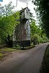 Spring Valley Mill |
| Beaumont Hall | Beaumont-cum-Moze, Tendring | House | Late 17th century | 29 April 1952 | TM1796924590 51°52′38″N 1°09′55″E |
1322628 | .jpg.webp) Beaumont Hall |
| Beaumont Rectory | Beaumont-cum-Moze, Tendring | House | c. 1800 | 29 April 1952 | TM1777324977 51°52′51″N 1°09′46″E |
1112125 | Upload Photo |
| Elmstead Hall | Elmstead, Tendring | House | Later | 21 February 1950 | TM0642326001 51°53′40″N 0°59′55″E |
1146647 |  Elmstead Hall |
| Church of All Saints | Great Holland, Frinton and Walton, Tendring | Parish Church | C15/C16 | 21 June 1950 | TM2191819356 51°49′43″N 1°13′09″E |
1165610 | 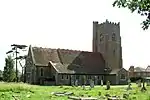 Church of All Saints |
| Church of St Mary | Frinton-on-Sea, Frinton and Walton, Tendring | Church | 14th century | 21 June 1950 | TM2371819483 51°49′45″N 1°14′43″E |
1111530 | 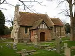 Church of St Mary |
| Church of St Michael | Kirby-le-Soken, Frinton and Walton, Tendring | Parish Church | 14th century | 22 June 1950 | TM2196022033 51°51′10″N 1°13′17″E |
1111500 | 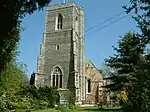 Church of St Michael |
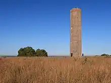
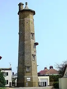
| Naze Tower | Walton-on-the-Naze, Frinton and Walton, Tendring | Navigational tower | 1720 | 21 June 1984 | TM2648623539 51°51′52″N 1°17′17″E |
1165846 | |
| The Homestead | Frinton on Sea, Frinton and Walton, Tendring | House | 1905-6 | 18 May 1979 | TM2335319396 51°49′43″N 1°14′24″E |
1111531 | 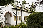 The Homestead |
| Copley Dene and Wall Attached to Left | Great Bromley, Tendring | House | Early/mid 18th century | 21 February 1950 | TM0846925427 51°53′18″N 1°01′41″E |
1147103 | Upload Photo |
| Church of All Saints | Dovercourt, Harwich, Tendring | Church | Medieval | 25 September 1951 | TM2383931102 51°56′00″N 1°15′17″E |
1205059 | 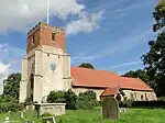 Church of All Saints |
| Church of St Nicholas | Harwich, Tendring | Church | 1822 | 25 September 1951 | TM2611632584 51°56′45″N 1°17′19″E |
1281276 | 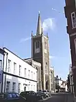 Church of St Nicholas |
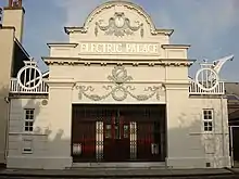
| Electric Palace Cinema | Harwich, Tendring | Cinema | 1911 | 18 September 1972 | TM2613232673 51°56′48″N 1°17′20″E |
1204934 | |
| High House | Harwich, Tendring | House | c. 1820 | 30 June 1964 | TM2615032541 51°56′43″N 1°17′21″E |
1204838 | Upload Photo |
| High Lighthouse | Harwich, Tendring | Lighthouse | Disused | 30 June 1964 | TM2611632438 51°56′40″N 1°17′19″E |
1280598 | |
| No 26, Kings Head St. and Frontage Wall to South East | Harwich, Tendring | House | Late 16th century | 25 September 1951 | TM2595632764 51°56′51″N 1°17′11″E |
1281089 | Upload Photo |
| Old Naval Yard Crane | Harwich, Tendring | Crane | 1667 | 25 September 1951 | TM2621232468 51°56′41″N 1°17′24″E |
1187899 | 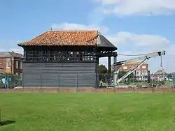 Old Naval Yard Crane |
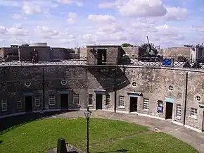
| Redoubt | Harwich, Tendring | Moat | 1808-1810 | 20 June 1972 | TM2616432179 51°56′32″N 1°17′21″E |
1187916 | |
| The Old Swan House | Harwich, Tendring | House | 16th century | 25 September 1951 | TM2597232720 51°56′49″N 1°17′12″E |
1281210 | Upload Photo |
| 10 King's Quay Street | Harwich, Tendring | House | Late 18th century | 20 June 1972 | TM2602932778 51°56′51″N 1°17′15″E |
1187905 | Upload Photo |
| 34 and 35 Church Street | Harwich, Tendring | House | 17th century | 25 September 1951 | TM2592632710 51°56′49″N 1°17′10″E |
1187884 | Upload Photo |
| 42 and 42a Church Street | Harwich, Tendring | House | Mid 18th century | 25 September 1951 | TM2595532718 51°56′49″N 1°17′11″E |
1298480 | Upload Photo |
| Church of St Mary | Little Bromley, Tendring | Parish Church | Early 12th century | 17 November 1966 | TM0917527821 51°54′35″N 1°02′23″E |
1337175 | |
| Church of St James | Little Clacton, Tendring | Parish Church | Earlier than 14th century | 17 November 1966 | TM1661218820 51°49′34″N 1°08′31″E |
1165915 | 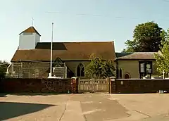 Church of St James |
| St Mary's House | Little Oakley, Tendring | House | 1987 | 30 January 1987 | TM2120928462 51°54′39″N 1°12′53″E |
1112098 | Upload Photo |
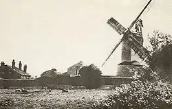
| Ramsey Windmill | Ramsey and Parkeston, Tendring | Windmill | 1842 | 29 April 1952 | TM2092130407 51°55′42″N 1°12′43″E |
1147549 | |
| Roydon Hall Farmhouse | Ramsey and Parkeston, Tendring | Jettied House | Late 16th century | 29 April 1952 | TM1896930206 51°55′38″N 1°11′00″E |
1308521 | Upload Photo |
| White House Farmhouse | Ramsey and Parkeston, Tendring | Farmhouse | Mid 16th century | 30 January 1987 | TM2099030248 51°55′37″N 1°12′46″E |
1112106 | Upload Photo |
| Little Priory & the Old House | St Osyth, Tendring | House | c. 1530 | 29 April 1952 | TM1234315569 51°47′54″N 1°04′41″E |
1166252 | Upload Photo |
| St Osyth's Priory Outbuilding Adjacent to North of Dairy Qv 15/188 Now a Barn | St. Osyth, Tendring | Barn | Medieval | 21 February 1950 | TM1205715701 51°47′59″N 1°04′27″E |
1166310 | Upload Photo |
| St Osyth's Priory Wall Between Southern Wing of Convalescent Home Qv 15/197 and Darcy Tower Qv 15/199 | St. Osyth, Tendring | Gate | 1987 | 21 February 1950 | TM1215515709 51°47′59″N 1°04′32″E |
1111465 | Upload Photo |
| St Osyth's Priory boundary walls | St. Osyth, Tendring | Wall | Mainly 14th-17th century, possibly 12th century in origin | 21 February 1950 | TM1205915566 | 1337160 | 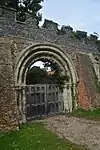 St Osyth's Priory boundary walls |
| Church of St Edmund | Tendring | Parish Church | 13th century | 17 November 1966 | TM1433724152 51°52′29″N 1°06′44″E |
1112122 | 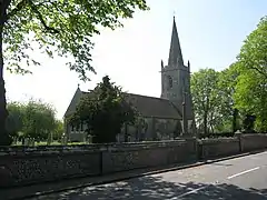 Church of St Edmund |
| Comarques | Thorpe-le-Soken, Tendring | House | Mid 18th century | 29 April 1952 | TM1748922640 51°51′36″N 1°09′26″E |
1112108 | Upload Photo |
| Parish Church of St Michael | Thorpe-le-Soken, Tendring | Church | 15th century | 30 January 1987 | TM1792922294 51°51′24″N 1°09′48″E |
1147716 | 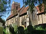 Parish Church of St Michael |
| The Abbey | Thorpe-le-Soken, Tendring | Jettied House | Mid 16th century | 29 April 1952 | TM1806422286 51°51′24″N 1°09′55″E |
1322618 | 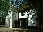 The Abbey |
| The Bell Hotel | Thorpe-le-Soken, Tendring | Church House | c. 1500 | 29 April 1952 | TM1796822310 51°51′24″N 1°09′50″E |
1112112 |  The Bell Hotel |
| Church of St Mary Magdelene | Thorrington, Tendring | Parish Church | Early 14th century | 17 November 1966 | TM0985819622 51°50′09″N 1°02′41″E |
1265150 | 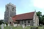 Church of St Mary Magdelene |
| Thorrington Tide Mill and Attached Dam Wall to North West | Thorrington, Tendring | Mill and Dam | 19th century | 29 April 1952 | TM0823419438 51°50′05″N 1°01′15″E |
1265152 | 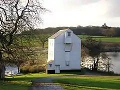 Thorrington Tide Mill and Attached Dam Wall to North West |
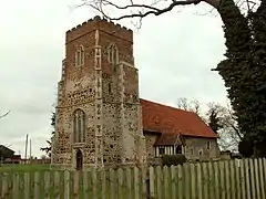
| Church of St Andrew | Weeley, Tendring | Parish Church | C15/C16 | 17 November 1966 | TM1541821528 51°51′03″N 1°07′35″E |
1265107 | .jpg.webp) Church of St Andrew |
| Parish Church of All Saints | Wrabness, Tendring | Church | Early 12th century | 30 January 1987 | TM1742431889 51°56′35″N 1°09′43″E |
1112074 | 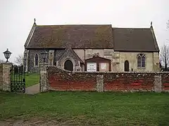 Parish Church of All Saints |
| Cann Hall | Tendring | House | 18th century | 4 July 1986 | TM1664416767 51°48′27″N 1°08′28″E |
1111549 | Upload Photo |
| Church of St James | Tendring | Church | 1912-12 | 5 March 1997 | TM1722114528 51°47′14″N 1°08′53″E |
1257896 | 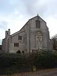 Church of St James |
Notes
- The date given is the date used by Historic England as significant for the initial building or that of an important part in the structure's description.
- Sometimes known as OSGB36, the grid reference is based on the British national grid reference system used by the Ordnance Survey.
- The "List Entry Number" is a unique number assigned to each listed building and scheduled monument by Historic England.
External links
This article is issued from Wikipedia. The text is licensed under Creative Commons - Attribution - Sharealike. Additional terms may apply for the media files.