Grade II* listed buildings in Thurrock
There are over 20,000 Grade II* listed buildings in England. This page is a list of these buildings in the district of Thurrock in Essex.
Thurrock
| Name | Location | Type | Completed [note 1] | Date designated | Grid ref.[note 2] Geo-coordinates |
Entry number [note 3] | Image |
|---|---|---|---|---|---|---|---|
| Kenningtons | Aveley, Thurrock | House | Later | 8 February 1960 | TQ5629781745 51°30′47″N 0°15′04″E |
1147634 |  Upload Photo |
| Bretts Farmhouse | Aveley | Farmhouse | Late 14th century or early 15th century | 8 February 1960 | TQ5598881957 51°30′54″N 0°14′48″E |
1111561 | Upload Photo |
| Church of St John the Baptist | Mucking | Church | 13th century | 8 February 1960 | TQ6853081182 51°30′16″N 0°25′37″E |
1337106 | 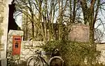 Church of St John the Baptist |
| Church of St Mary and All Saints | Langdon Hills | Church | Early 16th century | 28 August 1981 | TQ6728086342 51°33′04″N 0°24′41″E |
1337108 | .jpg.webp) Church of St Mary and All Saints |
| Church of St Mary the Virgin | Little Thurrock | Church | 12th century | 8 February 1960 | TQ6262777792 51°28′33″N 0°20′25″E |
1111628 | 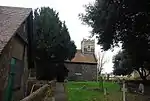 Church of St Mary the Virgin |
| Copeland House | Fobbing | A Frame House | 14th century | 8 February 1960 | TQ7167684152 51°31′49″N 0°28′25″E |
1337112 | Upload Photo |
| Garden Walls and Gateway at Little Belhus | South Ockendon | Gate | Mid 16th century | 8 February 1960 | TQ5852282186 51°30′59″N 0°17′00″E |
1111580 | Upload Photo |
| Bell Inn | Horndon on the Hill | Jettied House | Late 14th century | 8 February 1960 | TQ6703483265 51°31′25″N 0°24′23″E |
1337114 | .jpg.webp) Bell Inn |
| High House | Horndon on the Hill | House | Early 18th century | 8 February 1960 | TQ6700583304 51°31′26″N 0°24′21″E |
1308738 | Upload Photo |
| Little Belhus | South Ockendon | Timber Framed House | Mid 16th century | 8 February 1960 | TQ5851082154 51°30′58″N 0°16′59″E |
1147262 | Upload Photo |
| Marshall's Cottages | West Tilbury | Cross Wing House | Early 15th century | 8 February 1960 | TQ6606378225 51°28′43″N 0°23′24″E |
1337058 | Upload Photo |
| Officers Barracks, Tilbury Fort | Tilbury | Back to Back House | 1772 | 8 July 1998 | TQ6515475336 51°27′11″N 0°22′32″E |
1375568 | 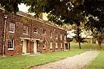 Officers Barracks, Tilbury Fort |
| Old Plough House | Bulphan | House | 16th century | 8 February 1960 | TQ6421686435 51°33′10″N 0°22′02″E |
1337059 | Upload Photo |
| Orsett House | Orsett | House | Early to mid 18th century | 8 February 1960 | TQ6397681975 51°30′46″N 0°21′42″E |
1111610 | Upload Photo |
| Purfleet Play Centre and Attached Wall to South | Purfleet | Boundary Wall | Mid 1760s | 17 April 2009 | TQ5491878592 51°29′06″N 0°13′47″E |
1393264 | Upload Photo |
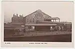
| Riverside Station (including Floating Landing Stage) | Tilbury | Railway Station | 1924 | 28 December 1989 | TQ6438875132 51°27′05″N 0°21′52″E |
1111547 | |
| St Clere's Hall | Mucking | Farmhouse | Late 17th century | 8 February 1960 | TQ6752981966 51°30′42″N 0°24′46″E |
1111565 | Upload Photo |
| State Cinema | Grays | Shop | 1938 | 22 February 1985 | TQ6134077960 51°28′39″N 0°19′19″E |
1111543 | |
| Church of St James | West Tilbury | Former Church | Late 11th century or early 12th century | 8 February 1960 | TQ6613677704 51°28′26″N 0°23′27″E |
1111541 | .jpg.webp) Church of St James |

Notes
- The date given is the date used by Historic England as significant for the initial building or that of an important part in the structure's description.
- Sometimes known as OSGB36, the grid reference is based on the British national grid reference system used by the Ordnance Survey.
- The "List Entry Number" is a unique number assigned to each listed building and scheduled monument by Historic England.
External links
This article is issued from Wikipedia. The text is licensed under Creative Commons - Attribution - Sharealike. Additional terms may apply for the media files.