Grade II* listed buildings in Waverley, Surrey
There are over 20,000 Grade II* listed buildings in England. This page is a list of the 95 Grade II* listed buildings in the district of Waverley in Surrey. For similar lists in respect of the other ten districts of Surrey see Grade II* listed buildings in Surrey.
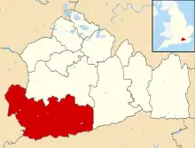
Waverley shown within Surrey
There are 95 Grade II* listed buildings in Waverley, with the largest number, 44, in the town of Farnham which is one of three towns in the district. Castle Street in Farnham has 17 Grade II* listed buildings, leading architectural historian Alec Clifton-Taylor to note that "for sheer visual delight, this street has few equals in all England".[1]
| Name | Location | Type | Completed [note 1] | Date designated | Grid ref.[note 2] Geo-coordinates |
Entry number [note 3] | Image |
|---|---|---|---|---|---|---|---|
| Alfold House | Alfold | House | 17th century | 9 March 1960 | TQ0398034099 51°05′48″N 0°30′59″W |
1044391 |  Upload Photo |
| Alfold Stores & the Magnolias | Alfold | House | Late 19th century | 28 September 1987 | TQ0390734031 51°05′46″N 0°31′03″W |
1044392 | Upload Photo |
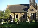
| Church of St Andrew | Grafham | Church | 1861-4 | 28 October 1986 | TQ0229641659 51°09′54″N 0°32′18″W |
1249496 | 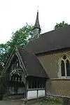 Church of St Andrew |
| East Manor House | Bramley | House | 16th century LATER THAN c1540 | 9 March 1960 | TQ0105644510 51°11′27″N 0°33′19″W |
1249485 | 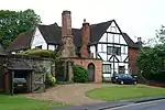 East Manor House |
| The Church of Holy Trinity | Bramley | Church | Early 13th century | 9 March 1960 | TQ0087944907 51°11′40″N 0°33′28″W |
1044581 | 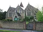 The Church of Holy Trinity |
| Barn 5 Yards South West of Skinners Land Farmhouse | Chiddingfold | Barn | 19th century | 17 June 1983 | SU9682936372 51°07′06″N 0°37′05″W |
1248593 | Upload Photo |
| Carriage House/Implement Shed 3 Yards South of Combe Court Farm | Chiddingfold | Dovecote | 1882 | 17 June 1983 | SU9416236107 51°06′59″N 0°39′22″W |
1248589 | 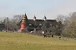 Carriage House/Implement Shed 3 Yards South of Combe Court Farm |
| Combe Court Farm | Chiddingfold | Hall House | 15th century | 17 June 1983 | SU9416536127 51°07′00″N 0°39′22″W |
1277813 | Upload Photo |
| Hadmans | Chiddingfold | House | 16th century | 9 March 1960 | SU9621035564 51°06′41″N 0°37′37″W |
1044603 | 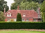 Hadmans |
| Lythe Hill Hotel | Chiddingfold | Farmhouse | 15th century | 9 March 1960 | SU9241932494 51°05′04″N 0°40′55″W |
1277848 | 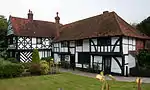 Lythe Hill Hotel |
| Pickhurst | Chiddingfold | House | Later alteration | 17 June 1983 | SU9670834144 51°05′54″N 0°37′13″W |
1248585 | |
| Skinners Land Farmhouse | Chiddingfold | House | C20 | 9 March 1960 | SU9682736389 51°07′07″N 0°37′05″W |
1277761 | Upload Photo |
| The Crown Inn | Chiddingfold | House | Later alterations | 9 March 1960 | SU9605535366 51°06′34″N 0°37′45″W |
1044569 | 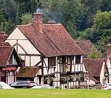 The Crown Inn |
| Church of St Nicholas | Cranleigh | Tower | 14th century | 9 March 1960 | TQ0598639139 51°08′30″N 0°29′11″W |
1044371 | 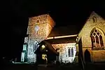 Church of St Nicholas |
| Elstead Mill | Elstead | Mill House | 16th century | 9 March 1960 | SU9035643832 51°11′12″N 0°42′31″W |
1044454 | 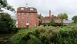 Elstead Mill |
| Church of St James | Westrook Hill, Elstead | Church | 13th century | 9 March 1960 | SU9032943402 51°10′58″N 0°42′32″W |
1188415 | 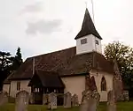 Church of St James |
| Marylands | Hurtwood, Ewhurst | House | Between 1929 and 1931 | 10 May 1994 | TQ0829242008 51°10′01″N 0°27′09″W |
1253713 | Upload Photo |
| White Hart Cottage | Ewhurst | House | 19th century | 12 September 1972 | TQ0906540749 51°09′20″N 0°26′31″W |
1044312 | 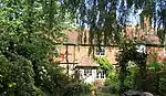 White Hart Cottage |
| Bethune House and Little House 88 and 88a West Street |
Farnham | House | Late 18th century | 26 April 1950 | SU8364946735 51°12′49″N 0°48′14″W |
1243072 | 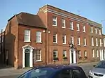 Bethune House and Little House 88 and 88a West Street |
| Castle Hill House 43 Castle Street |
Farnham | House | Earlier | 26 April 1950 | SU8385447158 51°13′03″N 0°48′03″W |
1378286 | 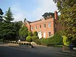 Castle Hill House 43 Castle Street |
| 1 and 2 Castle Street | Farnham | Inn | Modern | 26 April 1950 | SU8396446887 51°12′54″N 0°47′57″W |
1044679 | 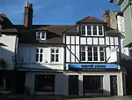 1 and 2 Castle Street |
| 73 and 74 Castle Street | Farnham | House | 18th century | 26 April 1950 | SU8397146940 51°12′56″N 0°47′57″W |
1117389 | 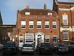 73 and 74 Castle Street |
| Elmer House 41 West Street |
Farnham | House | Late 18th century | 26 April 1950 | SU8354746652 51°12′47″N 0°48′19″W |
1259093 | 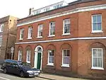 Elmer House 41 West Street |
| Garden Walls to Gardens East and North of the Grange | Farnham | Wall and gates | Early 18th century | 29 December 1972 | SU8359347409 51°13′11″N 0°48′16″W |
1242145 | 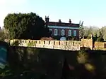 Garden Walls to Gardens East and North of the Grange |
| Guildford House 44 Castle Street |
Farnham | House | Late 18th century | 26 April 1950 | SU8387647122 51°13′02″N 0°48′02″W |
1242416 | 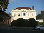 Guildford House 44 Castle Street |
| Hewetts Farmhouse | Farnham | Farmhouse | 16th century to 17th century | 29 December 1972 | SU8714847938 51°13′26″N 0°45′12″W |
1259919 | 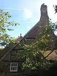 Hewetts Farmhouse |
| Ivy House (Conservative Club) | Farnham | House | Later alteration | 26 April 1950 | SU8397546819 51°12′52″N 0°47′57″W |
1116718 | 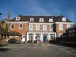 Ivy House (Conservative Club) |
| Moor Park House | Farnham | House | 17th century | 26 April 1950 | SU8621646529 51°12′41″N 0°46′02″W |
1319854 | |
| 5 and 5a Castle Street | Farnham | Stable/shop | Early to Mid 19th century | 29 December 1972 | SU8394346922 51°12′55″N 0°47′58″W |
1044681 | 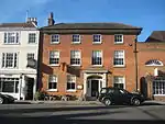 5 and 5a Castle Street |
| 67 and 68 Castle Street | Farnham | Shop | Late 18th century to Mid 19th century | 26 April 1950 | SU8394446991 51°12′57″N 0°47′58″W |
1044662 | 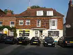 67 and 68 Castle Street |
| 76 Castle Street | Farnham | House | Late 18th century | 29 December 1972 | SU8398346916 51°12′55″N 0°47′56″W |
1044622 | 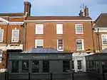 76 Castle Street |
| 35 and 36 The Borough | Farnham | House/Shop | 1950 | 26 April 1950 | SU8400646875 51°12′54″N 0°47′55″W |
1044666 | 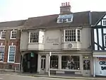 35 and 36 The Borough |
| Sandford House 39 West Street |
Farnham | House | 18th century | 26 April 1950 | SU8357946670 51°12′47″N 0°48′17″W |
1258471 | 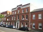 Sandford House 39 West Street |
| The Old Vicarage, Vicarage Lane | Farnham | House | 16th century | 26 April 1950 | SU8384346614 51°12′45″N 0°48′04″W |
1273555 | 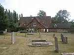 The Old Vicarage, Vicarage Lane |
| The Ranger's House, Farnham Park | Farnham Park, Farnham | Rangers House | 18th century | 26 April 1950 | SU8414747892 51°13′27″N 0°47′47″W |
1378305 | 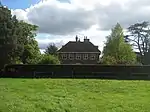 The Ranger's House, Farnham Park |
| 40 The Borough | Farnham | House | C16-C17 | 26 April 1950 | SU8398046866 51°12′53″N 0°47′56″W |
1044671 | 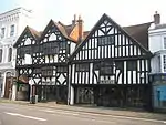 40 The Borough |
| Vernon House 28 West Street |
Farnham | House | 16th century | 26 April 1950 | SU8367346711 51°12′49″N 0°48′12″W |
1258122 |  Vernon House 28 West Street |
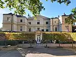
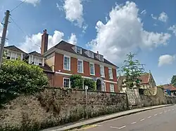
| Waverley Abbey House | Farnham | House | c. 1769 | 26 April 1950 | SU8683345547 51°12′09″N 0°45′31″W |
1258221 | 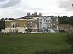 Waverley Abbey House |
| Weybourne House | Farnham | House | 1724 | 26 April 1950 | SU8541448747 51°13′54″N 0°46′41″W |
1243152 | 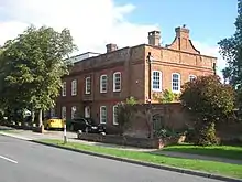 Weybourne House |
| William Cobbett Public House 4 Bridge Square |
Farnham | Timber Framed House | 17th century | 26 April 1950 | SU8414846523 51°12′42″N 0°47′48″W |
1044674 | 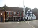 William Cobbett Public House 4 Bridge Square |
| Windsor Almshouses 53–60 Castle Street |
Farnham | Steps | 1619 | 26 April 1950 | SU8391047051 51°12′59″N 0°48′00″W |
1242457 | 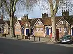 Windsor Almshouses 53–60 Castle Street |
| 70 Castle Street | Farnham | House | 1775 | 26 April 1950 | SU8395446969 51°12′57″N 0°47′58″W |
1044663 | 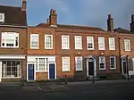 70 Castle Street |
| 3 Downing Street | Farnham | House | 1717 | 26 April 1950 | SU8401146648 51°12′46″N 0°47′55″W |
1044634 | 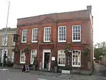 3 Downing Street |
| 62 Castle Street | Farnham | House | 18th century | 26 April 1950 | SU8392947021 51°12′58″N 0°47′59″W |
1044660 | 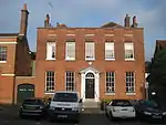 62 Castle Street |
| 9 Castle Street | Farnham | House | 18th century | 26 April 1950 | SU8392446960 51°12′56″N 0°47′59″W |
1044683 | 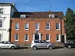 9 Castle Street |
| 45 Castle Street | Farnham | House | Early 18th century | 26 April 1950 | SU8388147106 51°13′01″N 0°48′01″W |
1044656 | 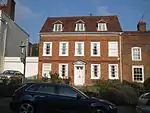 45 Castle Street |
| 43 The Borough | Farnham | Shop | 1932 | 26 April 1950 | SU8396846856 51°12′53″N 0°47′57″W |
1044672 |  43 The Borough |
| 48, 49 and 50 Downing Street | Farnham | Shop | Early 19th century | 26 April 1950 | SU8398046705 51°12′48″N 0°47′57″W |
1116966 | 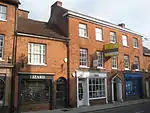 48, 49 and 50 Downing Street |
| 90 West Street | Farnham | House | 18th century | 26 April 1950 | SU8367446745 51°12′50″N 0°48′12″W |
1243074 | 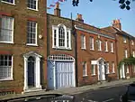 90 West Street |
| 6 and 7 Castle Street | Farnham | Shop | 19th century | 26 April 1950 | SU8393346937 51°12′56″N 0°47′59″W |
1242274 |  6 and 7 Castle Street |
| 89 West Street | Farnham | House | Late 18th century | 26 April 1950 | SU8366446741 51°12′50″N 0°48′13″W |
1243073 | 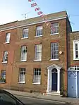 89 West Street |
| 10 Castle Street | Farnham | House | Early 18th century | 26 April 1950 | SU8390246961 51°12′57″N 0°48′00″W |
1260093 |  10 Castle Street |
| 23 and 24 West Street | Farnham | House | 1790 | 26 April 1950 | SU8375746754 51°12′50″N 0°48′08″W |
1259743 | 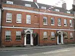 23 and 24 West Street |
| 104 West Street | Farnham | House | 18th century | 26 April 1950 | SU8376846785 51°12′51″N 0°48′07″W |
1273042 | 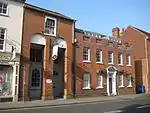 104 West Street |
| 91 and 92 West Street | Farnham | House | Late 18th century | 26 April 1950 | SU8368446750 51°12′50″N 0°48′12″W |
1273060 | 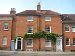 91 and 92 West Street |
| 4 Downing Street | Farnham | House | c. 1800 | 26 April 1950 | SU8399246653 51°12′46″N 0°47′56″W |
1378277 | 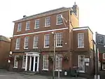 4 Downing Street |
| 71 Castle Street | Farnham | House | Post 1772 | 26 April 1950 | SU8396046958 51°12′56″N 0°47′57″W |
1117386 | 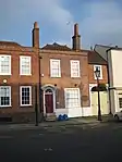 71 Castle Street |
| 61 Castle Street | Farnham | House | Late 18th century | 26 April 1950 | SU8392147033 51°12′59″N 0°47′59″W |
1242623 | 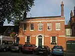 61 Castle Street |
| 12 and 13 Bridge Square | Farnham | House | Late 18th century | 26 April 1950 | SU8409946525 51°12′42″N 0°47′51″W |
1260235 | 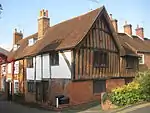 12 and 13 Bridge Square |
| 20, 20a and 21 West Street | Farnham | House | 18th century | 26 April 1950 | SU8377546760 51°12′50″N 0°48′07″W |
1258391 | 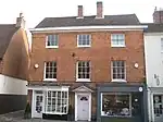 20, 20a and 21 West Street |
| 4 Castle Street | Farnham | Shop | Early 19th century | 26 April 1950 | SU8394846911 51°12′55″N 0°47′58″W |
1378260 | 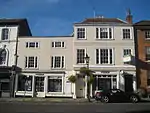 4 Castle Street |
| Church of St Mary the Virgin | Frensham | Church | 13th century | 9 March 1960 | SU8419141444 51°09′58″N 0°47′50″W |
1044427 | _(4).JPG.webp) Church of St Mary the Virgin |
| Pierrepont (Ellel Ministries) | Frensham | House | Earlier core | 3 May 1973 | SU8508942110 51°10′19″N 0°47′03″W |
1188515 | .jpg.webp) Pierrepont (Ellel Ministries) |
| Chapel at Charterhouse School | Godalming | School Chapel | 1927 | 16 January 1981 | SU9649445015 51°11′46″N 0°37′13″W |
1352726 | 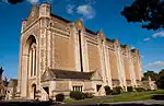 Chapel at Charterhouse School |
| Church of St John the Baptist | Busbridge | Church | 1865-7 | 23 February 1970 | SU9785542911 51°10′37″N 0°36′05″W |
1352706 | |
| Busbridge War Memorial | Busbridge | War memorial | 1922 | 1 February 1991 | SU9781142958 51°10′38″N 0°36′09″W |
1044531 | |
| 74, 74A, 76 & 76A High Street (Costa Coffee at 74) | Godalming | Apartment/Shop | C20 | 18 December 1947 | SU9699943845 51°11′08″N 0°36′49″W |
1293929 | 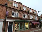 74, 74A, 76 & 76A High Street (Costa Coffee at 74) |
| Munstead Orchard | Busbridge | Timber Framed House | 1894 AND 1895 | 11 September 1987 | SU9798642835 51°10′35″N 0°35′59″W |
1294520 | Upload Photo |
| The Red House | Godalming | House | 1899 | 23 February 1970 | SU9678244977 51°11′45″N 0°36′59″W |
1044519 | Upload Photo |
| Westbrook | Westbrook, Godalming | Apartment | 1991 | 9 December 1988 | SU9611344264 51°11′22″N 0°37′34″W |
1299619 | Upload Photo |
| 80, High Street | Godalming | House/Shop | Mid-Late 17th century | 18 December 1947 | SU9698043844 51°11′08″N 0°36′50″W |
1293899 | 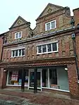 80, High Street |
| 99, 101 and 103 High Street | Godalming | Shops | C20 | 18 December 1947 | SU9687443810 51°11′07″N 0°36′55″W |
1044526 | 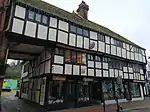 99, 101 and 103 High Street |
| Vann | Hambledon | Farmhouse | AFTER 1520 BY 18th century | 9 March 1960 | SU9827137548 51°07′44″N 0°35′49″W |
1261120 | Upload Photo |
| Church of St Peter | Hascombe | Church | 1864 | 28 October 1986 | TQ0018139542 51°08′47″N 0°34′09″W |
1240725 | 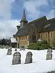 Church of St Peter |
| Amesbury School | Hindhead | House | 1903 | 23 January 1973 | SU8809834345 51°06′06″N 0°44′35″W |
1272562 |  Amesbury School |
| Branksome Conference Centre | Haslemere | Conference Centre | 1901 | 19 September 1977 | SU8850133512 51°05′39″N 0°44′15″W |
1244332 | 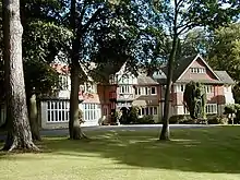 Branksome Conference Centre |
| Broad Dene | Haslemere | Gabled House | 1900 | 11 August 1975 | SU9010632629 51°05′09″N 0°42′54″W |
1244326 | 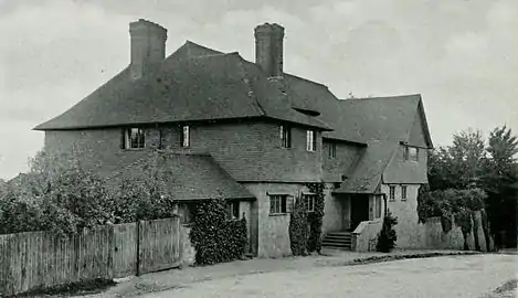 Broad Dene |
| Church Hill House | Haslemere | House | Early 18th century | 3 December 1953 | SU9031433386 51°05′34″N 0°42′42″W |
1243900 | |
| Kemnal | Haslemere | Gabled House | 1888 | 19 September 1977 | SU9081033397 51°05′34″N 0°42′17″W |
1243908 | Upload Photo |
| The White House | Grayswood, Haslemere | House | 1930 | 28 January 1971 | SU9186334859 51°06′20″N 0°41′21″W |
1244056 | Upload Photo |
| Town House | Haslemere | House | 18th century | 3 December 1953 | SU9056833075 51°05′23″N 0°42′29″W |
1244318 | 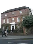 Town House |
| Tudor House | Haslemere | Timber Framed House | Early 17th century | 3 January 1953 | SU9002732999 51°05′21″N 0°42′57″W |
1272369 | .jpg.webp) Tudor House |
| Barn to North West Corner of Home Farm Courtyard | Peper Harow Park, Peper Harow | Courtyard | Early 18th century | 2 January 1986 | SU9344044210 51°11′22″N 0°39′52″W |
1188816 | 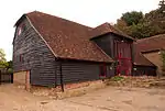 Barn to North West Corner of Home Farm Courtyard |
| Church of St Nicholas | Peper Harow Park, Peper Harow | Church | 12th century | 9 March 1960 | SU9346544062 51°11′17″N 0°39′50″W |
1352737 | 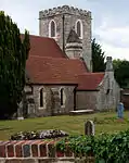 Church of St Nicholas |
| Dovecot and Granary to South West of Home Farm Courtyard | Peper Harow Park, Peper Harow | Dovecote | 18th century | 2 January 1986 | SU9343044162 51°11′21″N 0°39′52″W |
1044441 | 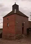 Dovecot and Granary to South West of Home Farm Courtyard |
| Home Farm Cottages with Stables to Left and Buildings to East | Peper Harow | House | 18th century | 2 January 1986 | SU9348144198 51°11′22″N 0°39′49″W |
1352736 | 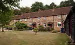 Home Farm Cottages with Stables to Left and Buildings to East |
| Somerset Bridge | Peper Harow | Bridge | 13th century | 9 March 1960 | SU9217743926 51°11′14″N 0°40′57″W |
1188935 | 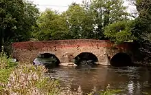 Somerset Bridge |
| Tilford House | Tilford | House | c. 1700 | 9 March 1960 | SU8699843596 51°11′06″N 0°45′24″W |
1352763 | .jpg.webp) Tilford House |
| Barn at Oxenford Grange | Witley | Barn | 1843 | 9 March 1960 | SU9323143217 51°10′50″N 0°40′03″W |
1334359 | 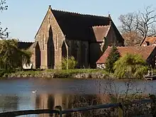 Barn at Oxenford Grange |
| Granary and Farm Buildings at Oxenford Farm | Witley | Farm Building | 1843 | 28 October 1986 | SU9320543244 51°10′51″N 0°40′05″W |
1097014 | Upload Photo |
| Oxenford Gate Lodge | Witley | Gate Lodge | 1843-4 | 9 March 1960 | SU9318343238 51°10′51″N 0°40′06″W |
1096948 |  Oxenford Gate Lodge |
| Statue of Neptune with Attached Underwater Tunnel, Stairs, Circular and Rectangular Chambers and Artificial Island, Witley Park | Witley Park, Witley | Steps | c. 1900 | 28 October 1986 | SU9217139560 51°08′52″N 0°41′01″W |
1096871 | 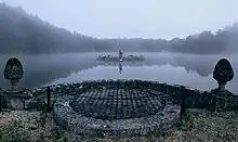 Statue of Neptune with Attached Underwater Tunnel, Stairs, Circular and Rectangular Chambers and Artificial Island, Witley Park |
| Barnett Hill (Conference Centre) |
Wonersh | House | c. 1905 | 28 October 1986 | TQ0243145442 51°11′56″N 0°32′07″W |
1241148 | 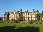 Barnett Hill (Conference Centre) |
| Church of St John the Baptist | Wonersh | Church | Pre Conquest | 9 March 1960 | TQ0146445098 51°11′46″N 0°32′57″W |
1241510 | 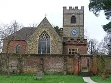 Church of St John the Baptist |
| The Dower House | Wonersh | House | c. 1710 | 9 March 1960 | TQ0182745235 51°11′50″N 0°32′39″W |
1241146 | Upload Photo |

See also
- Grade I listed buildings in Surrey (Waverley)
Notes
- The date given is the date used by Historic England as significant for the initial building or that of an important part in the structure's description.
- Sometimes known as OSGB36, the grid reference is based on the British national grid reference system used by the Ordnance Survey.
- The "List Entry Number" is a unique number assigned to each listed building and scheduled monument by Historic England.
References
- Clifton-Taylor, Alec (1963). "Future of a Georgian Town". Country Life. 134: 792.
External links
This article is issued from Wikipedia. The text is licensed under Creative Commons - Attribution - Sharealike. Additional terms may apply for the media files.