Grade II* listed buildings in Wealden
There are over 20,000 Grade II* listed buildings in England. This page is a list of these buildings in the district of Wealden in East Sussex.
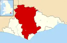
Wealden shown within East Sussex
Wealden
| Name | Location | Type | Completed [note 1] | Date designated | Grid ref.[note 2] Geo-coordinates |
Entry number [note 3] | Image |
|---|---|---|---|---|---|---|---|
| Court Farmhouse | Alciston, Wealden | Abbey | 14th century to 15th century | 13 October 1952 | TQ5056205530 50°49′47″N 0°08′12″E |
1043356 | 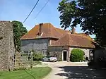 Court Farmhouse |
| Ruins of Dovecote North West of Court House Farm | Alciston, Wealden | Dovecote | Medieval | 13 October 1952 | TQ5054205563 50°49′48″N 0°08′11″E |
1043357 | .JPG.webp) Ruins of Dovecote North West of Court House Farm |
| The Old Clergy House | Alfriston, Wealden | Clergy House | 14th century | 13 October 1952 | TQ5213102951 50°48′22″N 0°09′28″E |
1191431 | |
| The Star Inn | Alfriston, Wealden | Public house | 15th century | 13 October 1952 | TQ5203803116 50°48′28″N 0°09′23″E |
1353267 | _(September_2011).JPG.webp) The Star Inn |
| Buxted Park | Buxted, Wealden | Hotel | c. 1722 | 26 November 1953 | TQ4853722810 50°59′08″N 0°06′53″E |
1353483 | |
| Courtyard with Terms, Balustrade and Fountain West Side of Buxted Park | Buxted, Wealden | Fountain | 19th century | 31 December 1982 | TQ4850122859 50°59′10″N 0°06′52″E |
1028438 | .jpg.webp) Courtyard with Terms, Balustrade and Fountain West Side of Buxted Park |
| Harrock House | Buxted, Wealden | House | Late 17th century | 26 November 1953 | TQ4895923569 50°59′32″N 0°07′16″E |
1028440 |  Upload Photo |
| Old Maypole Farmhouse | High Hurstwood, Buxted, Wealden | Farmhouse | 15th century | 26 November 1953 | TQ4943125665 51°00′39″N 0°07′43″E |
1191063 | Upload Photo |
| The Stables adjoining Buxted Park on the South West | Buxted, Wealden | House | After 1940 | 31 December 1982 | TQ4846222791 50°59′07″N 0°06′50″E |
1353484 | Upload Photo |
| Eckington House | Chalvington with Ripe, Wealden | Timber Framed House | Late 16th/early 17th century, or possibly older | 13 October 1952 | TQ5109410136 50°52′16″N 0°08′46″E |
1182750 | 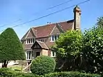 Eckington House |
| Eckington Manor | Chalvington with Ripe, Wealden | Manor | Early 18th century | 13 October 1952 | TQ5128109953 50°52′09″N 0°08′55″E |
1353411 | .jpg.webp) Eckington Manor |
| The Manor House | Chalvington with Ripe, Wealden | Manor House | Probably 16th century | 13 October 1952 | TQ5085110148 50°52′16″N 0°08′33″E |
1043089 | 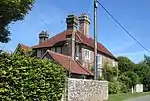 The Manor House |
| The Old Cottage | Chalvington with Ripe, Wealden | Timber Framed House | Or earlier | 13 October 1952 | TQ5097910087 50°52′14″N 0°08′40″E |
1043093 | 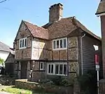 The Old Cottage |
| Barn to the North-east of Place Farmhouse | Chiddingly, Wealden | Great House | 30 August 1966 | TQ5415214382 50°54′30″N 0°11′28″E |
1043303 | Upload Photo | |
| Place Farmhouse | Chiddingly Village, Chiddingly, Wealden | Farmhouse | 16th century | 13 October 1952 | TQ5413414369 50°54′30″N 0°11′27″E |
1192781 | 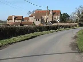 Place Farmhouse |
| Stone Hill | Chiddingly, Wealden | House | 1912 | 13 October 1952 | TQ5624215690 50°55′10″N 0°13′17″E |
1193017 | Upload Photo |
| Charleston Manor | Westdean, Cuckmere Valley, Wealden | House | 16th century | 13 October 1952 | TQ5208400650 50°47′08″N 0°09′22″E |
1353445 | 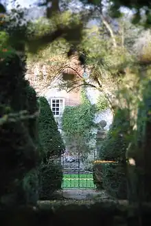 Charleston Manor |
| Two Barns to North East of Charleston Manor | Westdean, Cuckmere Valley, Wealden | Barn | Or earlier | 30 August 1966 | TQ5212700667 50°47′08″N 0°09′24″E |
1184424 | Upload Photo |
| Colin Godman's Farmhouse | Danehill, Wealden | Farmhouse | 16th century | 26 November 1953 | TQ4176227097 51°01′33″N 0°01′12″E |
1028455 | Upload Photo |
| The Cottages to the North of Friston Place | East Dean and Friston, Wealden | Stable | 1613-1664 | 30 August 1966 | TV5484298880 50°46′08″N 0°11′40″E |
1286068 | Upload Photo |
| The Dipperays and Gazebo | East Dean and Friston, Wealden | House | Late 18th century | 13 October 1952 | TV5564997870 50°45′34″N 0°12′20″E |
1353311 | .jpg.webp) The Dipperays and Gazebo |
| Barn at Halland Park Farm to South West of the Farmhouse | Shortgate, East Hoathly with Halland, Wealden | Barn | 17th century | 30 August 1966 | TQ5107915904 50°55′22″N 0°08′53″E |
1353376 | Upload Photo |
| Belmont | East Hoathly with Halland, Wealden | Vicarage | 18th century | 30 August 1966 | TQ5260416546 50°55′41″N 0°10′12″E |
1043255 | Upload Photo |
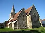
| The Parish Church | East Hoathly with Halland, Wealden | Parish Church | 15th century | 30 August 1966 | TQ5201516160 50°55′30″N 0°09′42″E |
1043285 | 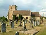 The Parish Church |
| Clinton Lodge | Fletching, Wealden | House | Late 17th century | 26 November 1953 | TQ4290223707 50°59′42″N 0°02′06″E |
1191500 | Upload Photo |
| Dale Hamme | Fletching, Wealden | Timber Framed House | 15th century | 26 November 1953 | TQ4414024520 51°00′07″N 0°03′10″E |
1028419 | Upload Photo |
| Sheffield Mill | Fletching, Wealden | Watermill | Commissioned 1597-98 | 17 October 1990 | TQ4156625766 51°00′50″N 0°01′00″E |
1353726 | Upload Photo |
| The Sheffield Arms Hotel | Sheffield Park, Fletching, Wealden | Hotel | 18th century | 26 November 1953 | TQ4115324890 51°00′22″N 0°00′38″E |
1028397 | .jpg.webp) The Sheffield Arms Hotel |
| Ashdown House School | Forest Row, Wealden | Country House | c. 1790 | 26 November 1953 | TQ4452535725 51°06′09″N 0°03′46″E |
1286907 | |
| Bower Farmhouse | Hammerwood, Forest Row, Wealden | Farmhouse | C15-16 | 26 November 1953 | TQ4378139143 51°08′01″N 0°03′13″E |
1191737 | Upload Photo |
| Church of St Stephen | Hammerwood, Forest Row, Wealden | Church | 1880 | 31 December 1982 | TQ439395 51°08′12″N 0°03′21″E |
1028406 | 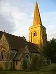 Church of St Stephen |
| Homestall Lodge (Stoke Brunswick School) | Ashurst Wood, Forest Row, Wealden | House | 1933 | 18 April 1973 | TQ4218237479 51°07′08″N 0°01′48″E |
1191682 | 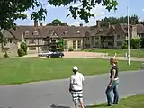 Homestall Lodge (Stoke Brunswick School) |
| Kidbrooke Park, Michael Hall - Rudolf Steiner School | Forest Row, Wealden | Country House | 18th century | 26 November 1953 | TQ4186834404 51°05′29″N 0°01′28″E |
1028377 | 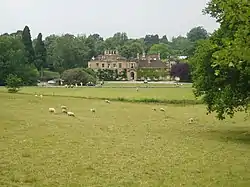 Kidbrooke Park, Michael Hall - Rudolf Steiner School |
| Stables to North of Kidbrooke Park | Forest Row, Wealden | Courtyard | 18th century | 26 November 1953 | TQ4186034456 51°05′31″N 0°01′28″E |
1028378 | Upload Photo |
| The Ruins of Brambletye House | Forest Row, Wealden | Country House | In the reign of James I | 26 November 1953 | TQ4173735413 51°06′02″N 0°01′23″E |
1353491 | 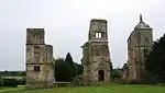 The Ruins of Brambletye House |
| Beckets | Framfield, Wealden | Timber Framed House | 15th century | 26 November 1953 | TQ4953220344 50°57′47″N 0°07′41″E |
1353522 | _(October_2010).JPG.webp) Beckets |
| Framfield Place | Framfield, Wealden | House | Early-mid 19th century | 27 January 1978 | TQ4936320420 50°57′50″N 0°07′32″E |
1028364 | Upload Photo |
| Lightlands | Frant, Wealden | House | 16th century | 26 November 1953 | TQ5967433369 51°04′39″N 0°16′41″E |
1192089 | Upload Photo |
| The Dower House, Bayham Abbey | Frant, Wealden | House | Before 1752 | 18 March 1977 | TQ6492936461 51°06′13″N 0°21′16″E |
1028367 | 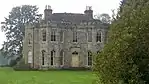 The Dower House, Bayham Abbey |
| Shepherds Hill including Terracing, Steps, Gatepiers and Garden House | Blackboys, Hadlow Down, Wealden | Farmhouse | 18th century | 26 November 1953 | TQ5154822217 50°58′46″N 0°09′27″E |
1028320 | Upload Photo |
| The Old Manor House | Hailsham, Wealden | House | Older building | 12 August 1981 | TQ5920909366 50°51′43″N 0°15′39″E |
1043237 | Upload Photo |
| The Old Vicarage | Hailsham, Wealden | House | 18th century | 30 August 1966 | TQ5921309511 50°51′47″N 0°15′40″E |
1353328 | .jpg.webp) The Old Vicarage |
| Bolebroke Castle | Hartfield, Wealden | Castle | 16th century | 26 November 1953 | TQ4749537767 51°07′13″N 0°06′22″E |
1028285 | |
| Old Marks | Holtye, Hartfield, Wealden | House | c. 1600 | 14 April 1994 | TQ4587139038 51°07′55″N 0°05′00″E |
1262177 | Upload Photo |
| Sussex House Farmhouse | Cowden, Hartfield, Wealden | Timber Framed House | C15-C16 | 26 November 1953 | TQ4704840076 51°08′28″N 0°06′02″E |
1028302 | Upload Photo |
| Heathfield Park | Heathfield and Waldron, Wealden | Great House | 1677 | 13 October 1952 | TQ5992020963 50°57′57″N 0°16′34″E |
1194135 | |
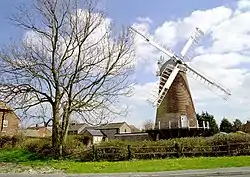
| New Mill | Cross In Hand, Heathfield and Waldron, Wealden | Post mill | 1806 | 13 October 1952 | TQ5579021751 50°58′27″N 0°13′03″E |
1183064 | |
| Possingworth Manor | Waldron, Heathfield and Waldron, Wealden | House | Early 17th century | 13 October 1952 | TQ5348220485 50°57′48″N 0°11′03″E |
1183094 | Upload Photo |
| Tanners Manor | Lions Green, Heathfield and Waldron, Wealden | Manor House | Early 17th century | 13 October 1952 | TQ5612318330 50°56′36″N 0°13′15″E |
1183044 | Upload Photo |
| The Gibraltar Tower, Heathfield Park | Heathfield and Waldron, Wealden | Tower | 1792-3 | 30 August 1966 | TQ5879021394 50°58′12″N 0°15′37″E |
1194199 | .jpg.webp) The Gibraltar Tower, Heathfield Park |
| All Saints Church | Old Heathfield Village, Heathfield and Waldron, Wealden | Parish Church | 13th century | 30 August 1966 | TQ5985620294 50°57′36″N 0°16′29″E |
1194397 | |
| Broad Farmhouse | Hellingly, Wealden | House | 1753 | 13 October 1952 | TQ5769412502 50°53′26″N 0°14′27″E |
1043198 | 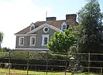 Broad Farmhouse |
| Carter's Corner Place Cowbeech | Cowbeech, Hellingly, Wealden | House | 1602 | 13 October 1952 | TQ6085912336 50°53′17″N 0°17′08″E |
1194627 | Upload Photo |
| The Mill Building at the Old Water Mill | Hellingly, Wealden | Mill | Or earlier | 13 October 1952 | TQ5849612522 50°53′26″N 0°15′08″E |
1180390 | .jpg.webp) The Mill Building at the Old Water Mill |
| Winkenhurst | Hellingly, Wealden | House | Early 19th century | 30 August 1966 | TQ5823814607 50°54′33″N 0°14′58″E |
1043196 | Upload Photo |
| Buckwell Place | Herstmonceux, Wealden | House | 1981 | 12 August 1981 | TQ6265912008 50°53′05″N 0°18′40″E |
1043143 | Upload Photo |
| Court Horeham | Cowbeech, Herstmonceux, Wealden | Timber Framed House | Or earlier | 30 August 1966 | TQ6097215166 50°54′49″N 0°17′19″E |
1043176 | Upload Photo |
| Cowbeech House | Cowbeech, Herstmonceux, Wealden | House | 1731 | 30 August 1966 | TQ6195714518 50°54′27″N 0°18′08″E |
1353335 | Upload Photo |
| Herstmonceux Science Centre | Herstmonceux, Wealden | Workshop | 1953-1958 | 26 March 2003 | TQ6516010473 50°52′13″N 0°20′45″E |
1391813 | .jpg.webp) Herstmonceux Science Centre |
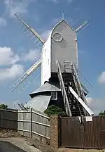
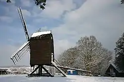
| The Windmill | Windmill Hill, Herstmonceux, Wealden | Post Mill | c. 1814 | 13 October 1952 | TQ6470612154 50°53′07″N 0°20′25″E |
1285093 | |
| Court Lodge | Hooe, Wealden | Lodge | 17th century | 13 October 1952 | TQ6852508771 50°51′14″N 0°23′34″E |
1285042 | Upload Photo |
| Isfield Place | Isfield, Wealden | House | Early 17th century | 26 November 1953 | TQ4463018458 50°56′51″N 0°03′27″E |
1192811 | Upload Photo |
| Ruins of Laughton Place | Laughton, Wealden | Farmhouse | 18th century | 13 October 1952 | TQ4834511425 50°53′00″N 0°06′27″E |
1043133 | 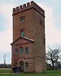 Ruins of Laughton Place |
| Central Building of Wootton Manor | Long Man, Wealden | Farmhouse | Mid 17th century | 13 October 1952 | TQ5654305193 50°49′30″N 0°13′17″E |
1043258 |  Central Building of Wootton Manor |
| Folkington Manor | Folkington, Long Man, Wealden | House | 1843 | 10 December 1973 | TQ5612304062 50°48′54″N 0°12′53″E |
1043257 | |
| Chequers Hotel | Maresfield, Wealden | Hotel | 18th century | 26 November 1953 | TQ4662224039 50°59′49″N 0°05′17″E |
1193093 | _(October_2010).JPG.webp) Chequers Hotel |
| Marshalls Manor | Maresfield, Wealden | House | 16th century | 26 November 1953 | TQ4521225019 51°00′22″N 0°04′06″E |
1028223 | .jpg.webp) Marshalls Manor |
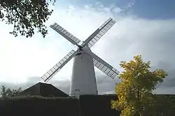
| Nutley Windmill | Nutley, Maresfield, Wealden | Post Mill | c. 1680 | 18 April 1973 | TQ4509929082 51°02′34″N 0°04′06″E |
1353574 | |
| The Shelly Arms Hotel | Nutley, Maresfield, Wealden | Hotel | 18th century | 26 November 1953 | TQ4422528085 51°02′03″N 0°03′20″E |
1353573 | Upload Photo |
| Argos Hill Windmill | Argos Hill, Mayfield and Five Ashes, Wealden | Post Mill | Unknown | 26 November 1953 | TQ5702028298 51°01′57″N 0°14′17″E |
1353580 | |
| Stone House | Mayfield and Five Ashes, Wealden | Guest House | 18th century | 26 November 1953 | TQ5871327018 51°01′14″N 0°15′42″E |
1028179 | Upload Photo |
| Walnut Tree House | Mayfield and Five Ashes, Wealden | House | 16th century | 26 November 1953 | TQ5873026989 51°01′13″N 0°15′42″E |
1193529 | Upload Photo |
| Yew Tree Farmhouse | Mayfield and Five Ashes, Wealden | Farmhouse | 18th century front | 26 November 1953 | TQ5919727110 51°01′17″N 0°16′06″E |
1193488 | Upload Photo |
| Hollis Street Farmhouse | Ninfield, Wealden | Farmhouse | Or earlier | 13 October 1952 | TQ7107611276 50°52′32″N 0°25′49″E |
1353382 | Upload Photo |
| Luxford House | Ninfield, Wealden | Farmhouse | Late 17th century | 13 October 1952 | TQ6922812793 50°53′23″N 0°24′17″E |
1043114 | Upload Photo |
| Standard Hill Farmhouse | Ninfield, Wealden | Farmhouse | 1659 | 13 October 1952 | TQ6969112674 50°53′19″N 0°24′40″E |
1043113 | Upload Photo |
| Tanyard House | Russell's Green, Ninfield, Wealden | House | 18th century | 13 October 1952 | TQ6982310917 50°52′22″N 0°24′44″E |
1043118 | Upload Photo |
| The Chapel at Otteham Court to the North West of the House | Polegate, Wealden | Abbey | c. 1350 | 13 October 1952 | TQ5875405712 50°49′45″N 0°15′10″E |
1182639 | Upload Photo |
| Flight of Steps with Retaining Wall, Pool and Statue about 110m east of Rotherfield Hall | Jarvis Brook, Rotherfield, Wealden | Garden Steps | Probably 1897 | 22 May 1989 | TQ5440228974 51°02′22″N 0°12′03″E |
1353721 | Upload Photo |
| Pond with Statue in Walled Garden to West of Rotherfield | Jarvis Brook, Rotherfield, Wealden | Statue | Probably 1897 | 22 May 1989 | TQ5426228988 51°02′22″N 0°11′56″E |
1027953 | Upload Photo |
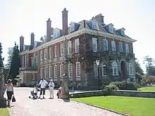
| Rotherfield Hall | Jarvis Brook, Rotherfield, Wealden | House | 1535 | 26 November 1953 | TQ5429128983 51°02′22″N 0°11′58″E |
1353619 | .jpg.webp) Rotherfield Hall |
| Series of 4 Bridges over Stream and Inlet to West of Rotherfield Hall | Jarvis Brook, Rotherfield, Wealden | Bridge | 1897 | 22 May 1989 | TQ5412829060 51°02′25″N 0°11′49″E |
1027954 | Upload Photo |
| South West Gateway to Rotherfield Hall | Jarvis Brook, Rotherfield, Wealden | Gate | 1897 | 22 May 1989 | TQ5402628896 51°02′20″N 0°11′44″E |
1027955 | .jpg.webp) South West Gateway to Rotherfield Hall |
| Walled Garden to West of Rotherfield Hall including Terrace, Walls, Steps, Arcade, Summerhouse and 2 Gazebos | Jarvis Brook, Rotherfield, Wealden | Balustrade | 1897 | 22 May 1989 | TQ5426728960 51°02′21″N 0°11′56″E |
1252660 | Upload Photo |
| Cobb Court | Selmeston, Wealden | House | 18th century | 13 October 1952 | TQ5228908048 50°51′07″N 0°09′44″E |
1353394 | 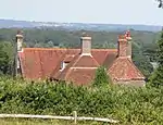 Cobb Court |
| Mays, flanking Walls and Gate-piers | Selmeston, Wealden | House | 18th century | 13 October 1952 | TQ5208607874 50°51′01″N 0°09′33″E |
1043056 | 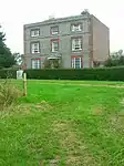 Mays, flanking Walls and Gate-piers |
| Copping Hall | Uckfield, Wealden | House | Early 18th century | 26 November 1953 | TQ4719621451 50°58′25″N 0°05′43″E |
1353642 | Upload Photo |
| Hempstead Manor Farmhouse | Uckfield, Wealden | Farmhouse | 15th century | 26 November 1953 | TQ4859721730 50°58′33″N 0°06′55″E |
1028392 | Upload Photo |
| Hooke Hall | Uckfield, Wealden | House | 18th century | 26 November 1953 | TQ4742221525 50°58′27″N 0°05′54″E |
1194393 | .jpg.webp) Hooke Hall |
| Barn about 50m north of Chittinghurst | Tidebrook, Wadhurst, Wealden | House | Possibly part used as such | 12 October 1989 | TQ6154229088 51°02′18″N 0°18′10″E |
1027956 | Upload Photo |
| Great Shoesmiths Farmhouse | Wadhurst, Wealden | Farmhouse | 15th century | 26 November 1953 | TQ6280934593 51°05′15″N 0°19′24″E |
1353651 | Upload Photo |
| Riverhall | Wadhurst, Wealden | House | 16th century | 26 November 1953 | TQ6054333324 51°04′36″N 0°17′25″E |
1028091 | Upload Photo |
| The Vicarage | Wadhurst, Wealden | Vicarage | Early 18th century | 26 November 1953 | TQ6394231906 51°03′47″N 0°20′18″E |
1194656 | .jpg.webp) The Vicarage |
| Walland | Wadhurst, Wealden | Timber Framed House | 15th century | 26 November 1953 | TQ6414430171 51°02′51″N 0°20′25″E |
1194538 | Upload Photo |
| Wenbans | Scrag Oak, Wadhurst, Wealden | House | 16th century | 26 November 1953 | TQ6336929780 51°02′39″N 0°19′45″E |
1285557 | Upload Photo |
| Cralle Place | Warbleton, Wealden | House | 16th century | 13 October 1952 | TQ6084416073 50°55′18″N 0°17′13″E |
1028562 | Upload Photo |
| Kingsley Hill | Warbleton Village, Warbleton, Wealden | Timber Framed House | Maybe late 17th century | 30 August 1966 | TQ6156717964 50°56′19″N 0°17′53″E |
1353415 | Upload Photo |
| Stone House | Rushlake Green Village, Warbleton, Wealden | House | Early 16th century | 13 October 1952 | TQ6291718512 50°56′35″N 0°19′03″E |
1043044 | Upload Photo |
| The Old Rectory | Warbleton Village, Warbleton, Wealden | House | 15th century | 30 August 1966 | TQ6130817915 50°56′17″N 0°17′40″E |
1198296 | Upload Photo |
| The Priory | Rushlake Green, Warbleton, Wealden | House | c. 1413 | 30 August 1966 | TQ6406118135 50°56′22″N 0°20′01″E |
1043041 | Upload Photo |
| Tom Beckworth | Rushlake Green Village, Warbleton, Wealden | House | Older | 13 October 1952 | TQ6266318222 50°56′26″N 0°18′50″E |
1043047 | Upload Photo |
| Windmill Hill Place (PGL residential children's activity Centre) | Windmill Hill, Wartling, Wealden | House | c. 1790 | 12 August 1981 | TQ6551011857 50°52′57″N 0°21′05″E |
1184336 |  Windmill Hill Place (PGL residential children's activity Centre) |
| Old Oak House | Westham, Wealden | Timber Framed House | 15th century | 13 October 1952 | TQ6411104596 50°49′04″N 0°19′42″E |
1184666 | Old Oak House |
| Stone Cross Windmill | Westham, Wealden | Windmill | 1876-77 | 13 October 1952 | TQ6196304316 50°48′57″N 0°17′52″E |
1184750 | |
| The Dial House | Westham, Wealden | Timber Framed House | 15th century | 13 October 1952 | TQ6408504584 50°49′03″N 0°19′41″E |
1028496 | _(March_2010).JPG.webp) The Dial House |
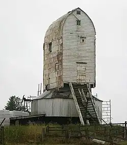
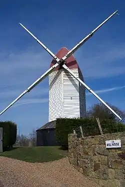
| Polegate (Ovenden's) Windmill | Willingdon and Jevington, Wealden | Tower Mill | 1817 | 13 October 1952 | TQ5815204072 50°48′53″N 0°14′37″E |
1043086 | |
| Duckings | Withyham, Wealden | Farmhouse | From 18th century or 19th century | 26 November 1953 | TQ4983635779 51°06′06″N 0°08′19″E |
1180420 | Upload Photo |
| Glen Andred | Groombridge, Withyham, Wealden | House | 1866-7 | 18 April 1973 | TQ5289835692 51°06′01″N 0°10′56″E |
1353682 | Upload Photo |
| Penns in the Rocks | Groombridge, Withyham, Wealden | House | About 1700 | 26 November 1953 | TQ5208934607 51°05′26″N 0°10′13″E |
1180617 | Upload Photo |
_(September_2011).JPG.webp)
_(October_2010).JPG.webp)


Notes
- The date given is the date used by Historic England as significant for the initial building or that of an important part in the structure's description.
- Sometimes known as OSGB36, the grid reference is based on the British national grid reference system used by the Ordnance Survey.
- The "List Entry Number" is a unique number assigned to each listed building and scheduled monument by Historic England.
External links
This article is issued from Wikipedia. The text is licensed under Creative Commons - Attribution - Sharealike. Additional terms may apply for the media files.