Grade II* listed buildings in Wycombe
There are over 20,000 Grade II* listed buildings in England. This page is a list of these buildings in the district of Wycombe in Buckinghamshire.
List
| Name | Location | Type | Completed [note 1] | Date designated | Grid ref.[note 2] Geo-coordinates |
Entry number [note 3] | Image |
|---|---|---|---|---|---|---|---|
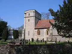
| Church of St Mary | Saunderton, Bledlow-cum-Saunderton, Wycombe | Parish Church | 14th century | 21 June 1955 | SP7955501890 51°42′36″N 0°51′00″W |
1332059 | 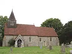 Church of St Mary |
| Forty Green Farmhouse | Forty Green, Bledlow-cum-Saunderton | Farmhouse | 1718 | 21 June 1955 | SP7662803312 51°43′24″N 0°53′31″W |
1332060 |  Upload Photo |
| Manor House | Bledlow, Bledlow-cum-Saunderton | House | c. 1670 | 21 June 1955 | SP7796402132 51°42′45″N 0°52′23″W |
1125803 | Upload Photo |
| The Old House Farmhouse | Bledlow-cum-Saunderton | Farmhouse | Late 15th century | 21 June 1955 | SP7905701896 51°42′37″N 0°51′26″W |
1310782 | Upload Photo |
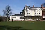
| Bradenham Manor | Bradenham | House | 16th century | 21 June 1955 | SU8287797081 51°39′59″N 0°48′11″W |
1332048 | 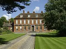 Bradenham Manor |
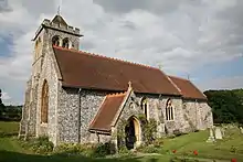
| Church of St Botolph | Bradenham | Parish Church | c. 1100 | 21 June 1955 | SU8283497126 51°40′01″N 0°48′13″W |
1125779 | 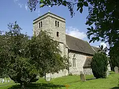 Church of St Botolph |
| The White House | Bradenham | House | c. 1800 | 21 June 1955 | SU8269597132 51°40′01″N 0°48′20″W |
1310723 |  The White House |
| Church of St Peter and St Paul | Ellesborough | Parish Church | late C14-C15 | 21 June 1955 | SP8363706739 51°45′11″N 0°47′23″W |
1125881 | 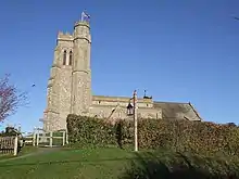 Church of St Peter and St Paul |
| Wellwick Manor | Ellesborough | House | 17th century | 25 October 1951 | SP8523807884 51°45′47″N 0°45′59″W |
1118401 |  Wellwick Manor |
| Wellwick Manor | Wendover | House | 17th century | 25 October 1951 | SP8523707886 51°45′47″N 0°45′59″W |
1332019 | Wellwick Manor |
| Church of St Mary the Virgin | Fawley | Parish Church | 12th century | 21 June 1955 | SU7535486716 51°34′27″N 0°54′51″W |
1125702 | |
| Freeman Mausoleum | Fawley | Mausoleum | 1750 | 7 February 1980 | SU7531686718 51°34′28″N 0°54′53″W |
1125703 | 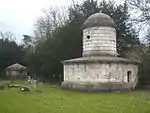 Freeman Mausoleum |
| Church of St Mary Magdalene | Great and Little Hampden | Parish Church | 13th century | 21 June 1955 | SP8484502369 51°42′49″N 0°46′24″W |
1158762 | 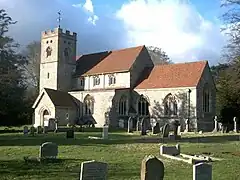 Church of St Mary Magdalene |
| Widmere Farmhouse | Widmere, Great Marlow | Farmhouse | late C17-early 18th century | 21 June 1955 | SU8319889195 51°35′44″N 0°48′01″W |
1332119 | Upload Photo |
| Church of St Mary | Hambleden | Parish Church | 12th century | 21 June 1955 | SU7839986604 51°34′22″N 0°52′13″W |
1160018 | 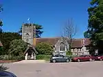 Church of St Mary |
| Greenlands (part of Henley Business School) | Greenlands, Hambleden | Country House | c. 1810 | 4 December 1992 | SU7757085483 51°33′46″N 0°52′56″W |
1125682 | 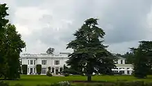 Greenlands (part of Henley Business School) |
| Hambleden Manor House | Hambleden | House | Early 17th century | 21 June 1955 | SU7851086651 51°34′24″N 0°52′07″W |
1125692 | 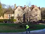 Hambleden Manor House |
| Kenricks | Hambleden | House | C19-C20 | 21 June 1955 | SU7867886515 51°34′19″N 0°51′58″W |
1160069 | Kenricks |
| Church of St Michael and All Angels | Hughenden Park, Hughenden | Parish Church | 14th century | 21 June 1955 | SU8642195526 51°39′07″N 0°45′08″W |
1125743 | |
| Church of St Nicholas | Ibstone | Parish Church | 12th century | 21 June 1955 | SU7560292336 51°37′29″N 0°54′33″W |
1160705 | 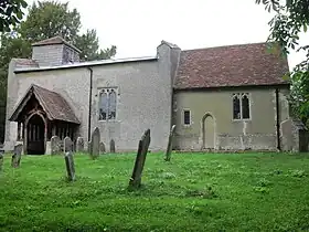 Church of St Nicholas |
| Windmill | Lacey Green | Smock Mill | mid-late 17th century | 26 April 1985 | SP8191600781 51°41′59″N 0°48′58″W |
1159021 | Apr2006.jpg.webp) Windmill |
| Church of St John the Baptist | Little Marlow | Parish Church | Late 12th century | 21 June 1955 | SU8740787826 51°34′57″N 0°44′24″W |
1311079 | 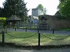 Church of St John the Baptist |
| Bank Farmhouse | Meadle, Longwick-cum-Ilmer | House | 15th century | 26 April 1985 | SP8068005980 51°44′48″N 0°49′58″W |
1159190 | Upload Photo |
| Church of St Michael and All Angels | Horsenden, Longwick-cum-Ilmer | Parish Church | 15th century | 21 June 1955 | SP7935502922 51°43′10″N 0°51′10″W |
1332032 | 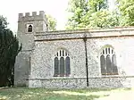 Church of St Michael and All Angels |
| Church of St Peter | Ilmer, Longwick-cum-Ilmer | Parish Church | 12th century | 21 June 1955 | SP7692205487 51°44′34″N 0°53′14″W |
1332033 | 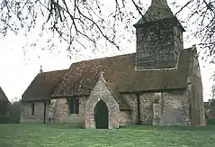 Church of St Peter |
| Sir William Borlase's Grammar School | Marlow | School | 1624 | 16 July 1949 | SU8454286412 51°34′13″N 0°46′54″W |
1217598 | |
| Brampton House | Marlow | House | 18th century | 16 July 1949 | SU8502686320 51°34′10″N 0°46′29″W |
1332409 |  Brampton House |
| Church of All Saints | Marlow | Parish Church | 1832-1835 | 16 July 1949 | SU8513886173 51°34′05″N 0°46′23″W |
1332380 | 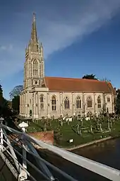 Church of All Saints |
| Court Garden | Marlow | Country House | 18th century | 31 January 1974 | SU8488386148 51°34′04″N 0°46′36″W |
1125078 | |
| Crown Hotel | Marlow | Town Hall/Hotel/Shops | 1807 | 16 July 1949 | SU8483786614 51°34′19″N 0°46′38″W |
1159570 | |
| Old Parsonage | Marlow | House | 14th century | 16 July 1949 | SU8515386368 51°34′11″N 0°46′22″W |
1125080 | 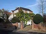 Old Parsonage |
| Remnantz | Marlow | House | 1799-1811 | 16 July 1949 | SU8462686402 51°34′13″N 0°46′49″W |
1275651 | |
| The Stables at Remnantz | Marlow | Gate Pier | 16 July 1949 | SU8466386382 51°34′12″N 0°46′47″W |
1275653 | 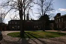 The Stables at Remnantz | |
| The End House | Marlow | House | Late 18th century | 16 July 1949 | SU8503286310 51°34′09″N 0°46′28″W |
1125072 | 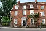 The End House |
| The Old House | Marlow | House | 18th century | 16 July 1949 | SU8479586509 51°34′16″N 0°46′40″W |
1235001 | 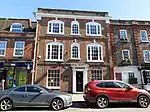 The Old House |
| The Old Malt House | Marlow | House | Late 18th century | 16 July 1949 | SU8518386234 51°34′07″N 0°46′21″W |
1275958 | Upload Photo |
| The White House | Marlow | House | c. 1730 | 16 July 1949 | SU8496886411 51°34′13″N 0°46′32″W |
1159481 | 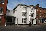 The White House |
| Western House | Marlow | House | 1699 | 16 July 1949 | SU8447786355 51°34′11″N 0°46′57″W |
1216983 | Upload Photo |
| 29 and 31 West Street | Marlow | House | 18th century | 16 July 1949 | SU8478686501 51°34′16″N 0°46′41″W |
1235047 | 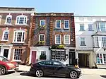 29 and 31 West Street |
| 33 West Street | Marlow | House | 18th century | 16 July 1949 | SU8478186487 51°34′15″N 0°46′41″W |
1275805 | Upload Photo |
| 47 West Street | Marlow | House | 18th century | 16 July 1949 | SU8473986462 51°34′14″N 0°46′43″W |
1216789 | Upload Photo |
| 41 and 41a High Street | Marlow | House | 18th century | 17 August 1970 | SU8496686471 51°34′15″N 0°46′32″W |
1332404 | 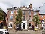 41 and 41a High Street |
| 74 and 76 High Street | Marlow | House | Mid 18th century | 16 July 1949 | SU8498086393 51°34′12″N 0°46′31″W |
1332408 | 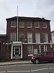 74 and 76 High Street |
| Church of St Peter and St Paul | Medmenham | Parish Church | Mid 12th century | 21 June 1955 | SU8047484472 51°33′12″N 0°50′27″W |
1310930 |  Church of St Peter and St Paul |
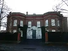
| Danesfield House | Danesfield, Medmenham | Country House | 1899-1901 | 9 August 1977 | SU8163084394 51°33′09″N 0°49′27″W |
1310810 | |
| Lodge Farmhouse | Medmenham | Farmhouse | 17th century | 21 June 1955 | SU8042384622 51°33′17″N 0°50′29″W |
1125591 | Upload Photo |
| Medmenham Abbey, Abbey House and Wall with Arch to Forecourt | Medmenham | Abbey | 1987 | 21 June 1955 | SU8068183826 51°32′51″N 0°50′16″W |
1310928 | Upload Photo |
| Wittingdon | Wittington, Medmenham | Country House | 1898 | 24 November 1976 | SU8209584414 51°33′10″N 0°49′02″W |
1125557 | 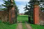 Wittingdon |
| Chipps Manor | Wheeler End, Piddington and Wheeler End | Farmhouse | 1733 | 21 June 1955 | SU8032293738 51°38′12″N 0°50′27″W |
1332101 | Upload Photo |
| Church of St Mary | Princes Risborough | Parish Church | 13th century | 21 June 1955 | SP8059703492 51°43′28″N 0°50′04″W |
1125815 | 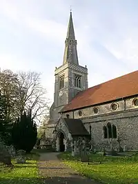 Church of St Mary |
| Dovecote West of St Dunstan's Church | Monks Risborough, Princes Risborough | Dovecote | 16th century | 21 June 1955 | SP8119204442 51°43′58″N 0°49′33″W |
1125788 | 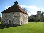 Dovecote West of St Dunstan's Church |
| Manor House and attached Garden Walls (north West Wall incorporated into the Forge and the Coach House) | Princes Risborough, Wycombe | House | 1955 | 21 June 1955 | SP8061603536 51°43′29″N 0°50′03″W |
1311048 | 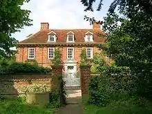 Manor House and attached Garden Walls (north West Wall incorporated into the Forge and the Coach House) |
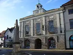
| Market House | Princes Risborough | Market House | 1824 | 21 June 1955 | SP8074203502 51°43′28″N 0°49′57″W |
1159718 | 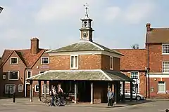 Market House |
| Church of St Peter and St Paul | Stokenchurch | Parish Church | 12th century | 21 June 1955 | SU7602996436 51°39′42″N 0°54′08″W |
1310455 | 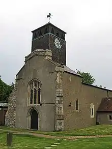 Church of St Peter and St Paul |
| Church of St Mary | Turville | Parish Church | 12th century | 21 June 1955 | SU7670191153 51°36′50″N 0°53′37″W |
1125644 | 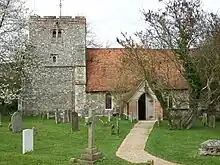 Church of St Mary |
| Northend Farmhouse | Turville | Farmhouse | c. 1700 | 21 June 1955 | SU7344792744 51°37′43″N 0°56′25″W |
1125674 | Upload Photo |
| The Old Vicarage | Turville | House | c. 1967 | 21 June 1955 | SU7665491165 51°36′51″N 0°53′40″W |
1125643 | 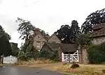 The Old Vicarage |
| Daphne's Temple, West Wycombe Park | West Wycombe | Temple | 18th century | 9 January 1954 | SU8329994644 51°38′40″N 0°47′51″W |
1160546 | 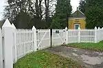 Daphne's Temple, West Wycombe Park |
| Flora's Temple, West Wycombe Park | West Wycombe | Loggia | Late 18th century | 9 January 1954 | SU8380494329 51°38′30″N 0°47′25″W |
1125121 | Upload Photo |
| Island Temple, West Wycombe Park | West Wycombe | Loggia | 1778-1780 | 9 January 1954 | SU8316294451 51°38′34″N 0°47′58″W |
1125125 | 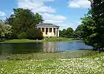 Island Temple, West Wycombe Park |
| North Lodge, West Wycombe Park | West Wycombe | Lodge | 18th century | 9 January 1954 | SU8333894641 51°38′40″N 0°47′49″W |
1125126 |  North Lodge, West Wycombe Park |
| North West Lodge and Gatepiers, West Wycombe Park | West Wycombe | Gate Pier | 18th century | 9 January 1954 | SU8277294647 51°38′40″N 0°48′19″W |
1125127 | Upload Photo |
| Sawmill House | West Wycombe | House | Late 18th century | 9 January 1954 | SU8373694141 51°38′23″N 0°47′29″W |
1332394 | Upload Photo |
| Small Temple, West Wycombe Park | West Wycombe | Dovecote | Later | 9 January 1954 | SU8284494261 51°38′28″N 0°48′15″W |
1125124 | 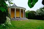 Small Temple, West Wycombe Park |
| Temple of Bacchus, West Wycombe Park | West Wycombe | Statue | 18th century | 28 June 1973 | SU8288594302 51°38′29″N 0°48′13″W |
1125084 | Upload Photo |
| Temple of the Four Winds, West Wycombe Park | West Wycombe | Temple | 18th century | 9 January 1954 | SU8318894170 51°38′25″N 0°47′57″W |
1160544 | 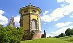 Temple of the Four Winds, West Wycombe Park |
| The Exedra, West Wycombe Park | West Wycombe | Wall | Late 18th century | 28 June 1973 | SU8289294288 51°38′29″N 0°48′13″W |
1125083 | .jpg.webp) The Exedra, West Wycombe Park |
| Triumphal (Cockpit) Arch, West Wycombe Park | West Wycombe | Arch | Late 18th century | 28 June 1973 | SU8290094288 51°38′29″N 0°48′12″W |
1160549 | 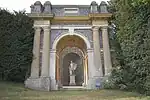 Triumphal (Cockpit) Arch, West Wycombe Park |
| The (Hellfire) Cave | West Wycombe | Cave | 1750-1752 | 9 January 1954 | SU8294294812 51°38′46″N 0°48′10″W |
1332393 | 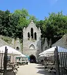 The (Hellfire) Cave |
| The Church Loft | West Wycombe | Guest House | Early 18th century | 9 January 1954 | SU8301594675 51°38′41″N 0°48′06″W |
1125134 | 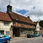 The Church Loft |
| The Dower House | West Wycombe | House | c. 1763 | 9 January 1954 | SU8302794698 51°38′42″N 0°48′05″W |
1160483 | Upload Photo |
| The Manor House | West Wycombe | House | Early 18th century | 9 January 1954 | SU8298794675 51°38′41″N 0°48′07″W |
1125135 | Upload Photo |
| Workshop (furniture Factory) adjoining No 37 High Street on North and occupied by EMF Brown | West Wycombe | Furniture Factory | Late 18th century or early 19th century | 9 January 1954 | SU8302194686 51°38′41″N 0°48′06″W |
1125174 | Upload Photo |
| Church of St Paul | Wooburn | Parish Church | Late 12th century | 21 June 1955 | SU9095387795 51°34′54″N 0°41′19″W |
1125542 | 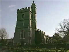 Church of St Paul |
| Clapton Revel | Wooburn | House | c1700-1710 | 17 October 1969 | SU9100290035 51°36′07″N 0°41′15″W |
1125541 | Upload Photo |
| Cores End Cottage, Cores End House | Wooburn | House | c. 1730 | 21 June 1955 | SU9041987249 51°34′37″N 0°41′48″W |
1160086 | Upload Photo |
| Bassetsbury Manor | Wycombe | Manor House | Late 17th century or early 18th century | 9 January 1954 | SU8765492378 51°37′24″N 0°44′07″W |
1310947 | 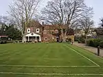 Bassetsbury Manor |
| Church of Saint Francis | Wycombe | Church | 1929-1930 | 28 June 1973 | SU8771994485 51°38′32″N 0°44′01″W |
1125114 | _-_geograph.org.uk_-_1575075.jpg.webp) Church of Saint Francis |
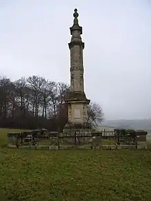
| Disraeli Monument | Wycombe | Wall | 1862 | 28 June 1973 | SU8565594619 51°38′38″N 0°45′49″W |
1125201 | |
| Hughenden Manor Farmhouse | Wycombe | Farmhouse | Late 17th century or early 18th century | 9 January 1954 | SU8575395117 51°38′54″N 0°45′43″W |
1125184 | Upload Photo |
| Premises occupied by Midland Bank | Wycombe | Bank (financial) | 18th century | 9 January 1954 | SU8653992996 51°37′45″N 0°45′04″W |
1125187 | Upload Photo |
| The Little Market House | Wycombe | Market House | c. 1604 | 9 January 1954 | SU8655693031 51°37′46″N 0°45′03″W |
1310836 | 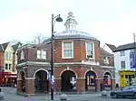 The Little Market House |
| Wycombe Abbey (parts of Wycombe Abbey School) | Wycombe | Manor House | 17th century | 9 January 1954 | SU8658192627 51°37′33″N 0°45′02″W |
1310649 | Upload Photo |
| 7 Castle Street | Wycombe | House | 18th century | 28 June 1973 | SU8656293129 51°37′49″N 0°45′03″W |
1159695 | Upload Photo |
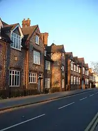
| 30 High Street | Wycombe | House | 18th century | 9 January 1954 | SU8666792924 51°37′42″N 0°44′58″W |
1159966 | Upload Photo |
| 33 High Street | Wycombe | House | 18th century | 9 January 1954 | SU8664292942 51°37′43″N 0°44′59″W |
1332337 | Upload Photo |
| 34 High Street | Wycombe | House | 18th century or earlier | 28 June 1973 | SU8662492942 51°37′43″N 0°45′00″W |
1125162 | Upload Photo |
| 39 High Street | Wycombe | Town House | 1st half of 18th century | 9 January 1954 | SU8657192981 51°37′44″N 0°45′02″W |
1125163 | Upload Photo |

Notes
- The date given is the date used by Historic England as significant for the initial building or that of an important part in the structure's description.
- Sometimes known as OSGB36, the grid reference is based on the British national grid reference system used by the Ordnance Survey.
- The "List Entry Number" is a unique number assigned to each listed building and scheduled monument by Historic England.
External links
This article is issued from Wikipedia. The text is licensed under Creative Commons - Attribution - Sharealike. Additional terms may apply for the media files.