Grade II* listed buildings in Wyre Forest (district)
There are over 20,000 Grade II* listed buildings in England. This page is a list of these buildings in the Wyre Forest district in Worcestershire.
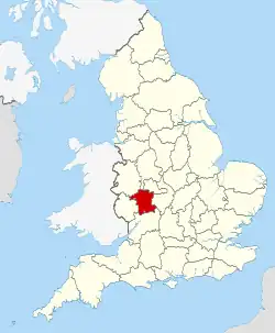
Worcestershire shown within England
Wyre Forest
| Name | Location | Type | Completed [note 1] | Date designated | Grid ref.[note 2] Geo-coordinates |
Entry number [note 3] | Image |
|---|---|---|---|---|---|---|---|
| Bailiff's House | Bewdley, Wyre Forest | House | Mid 19th century | 22 April 1950 | SO7859175253 52°22′30″N 2°18′57″W |
1348653 | 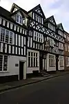 Bailiff's House |
| Beales Corner | Wribbenhall, Bewdley, Wyre Forest | House | Mid 19th century | 22 April 1950 | SO7883775418 52°22′35″N 2°18′44″W |
1099956 |  Beales Corner |
| Church of St Anne | Bewdley, Wyre Forest | Parish Church | 1695-6 | 22 April 1950 | SO7857875310 52°22′31″N 2°18′58″W |
1099966 | 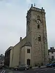 Church of St Anne |
| Number 62 (the Manor House) and Attached Railings | Bewdley, Wyre Forest | Apartment | Early 18th century | 22 April 1950 | SO7865975181 52°22′27″N 2°18′54″W |
1348654 |  Upload Photo |
| The Church of the Holy Family | Bewdley, Wyre Forest | Presbyterian Chapel | c. 1778 | 22 April 1950 | SO7861175180 52°22′27″N 2°18′56″W |
1099983 | Upload Photo |
| The Town Hall | Bewdley, Wyre Forest | Town Hall | 1808 | 22 April 1950 | SO7864275330 52°22′32″N 2°18′55″W |
1100788 | |
| Tickenhill | Bewdley, Wyre Forest | House | 15th century | 22 April 1950 | SO7847275094 52°22′24″N 2°19′04″W |
1348265 | Upload Photo |
| Winterdyne | Bewdley, Wyre Forest | House | Mid 18th century | 22 April 1950 | SO7909174661 52°22′11″N 2°18′31″W |
1348266 | Upload Photo |
| 5, 7 and 9 Stourport Road | Wribbenhall, Bewdley, Wyre Forest | House | Early 18th century | 24 March 1970 | SO7890375356 52°22′33″N 2°18′41″W |
1167365 | .JPG.webp) 5, 7 and 9 Stourport Road |
| 13 and 14 Load Street | Bewdley, Wyre Forest | House | Early 19th century | 24 March 1970 | SO7863375317 52°22′32″N 2°18′55″W |
1301049 | .JPG.webp) 13 and 14 Load Street |
| Drayton House | Drayton, Chaddesley Corbett, Wyre Forest | Country House | Early 18th century | 25 February 1958 | SO9072276202 52°23′02″N 2°08′16″W |
1167066 | Upload Photo |
| Hoarstone Farmhouse | Kidderminster Foreign, Wyre Forest | Farmhouse | Early 17th century | 25 February 1958 | SO7938676799 52°23′20″N 2°18′16″W |
1167685 | Upload Photo |
| Victoria Bridge | Kidderminster Foreign, Wyre Forest | Railway Bridge | 1859-1862 | 18 March 1987 | SO7666579254 52°24′39″N 2°20′40″W |
1100657 | |
| Church of St Giles | Heightington, Rock, Wyre Forest | Church | 13th century | 25 February 1958 | SO7675871162 52°20′17″N 2°20′33″W |
1145814 | .jpg.webp) Church of St Giles |
| Church House | Areley Kings, Stourport-on-Severn, Wyre Forest | Jettied House | Mid to late 16th century | 5 July 1950 | SO8021370961 52°20′11″N 2°17′31″W |
1217941 |  Church House |
| Church of St Bartholomew | Areley Kings, Stourport-on-Severn, Wyre Forest | Church | Norman | 5 July 1950 | SO8020071018 52°20′13″N 2°17′31″W |
1209472 |  Church of St Bartholomew |
| Lickhill Manor | Lickhill, Stourport-on-Severn, Wyre Forest | Country House | Late 17th century | 5 July 1950 | SO7968271818 52°20′39″N 2°17′59″W |
1209461 | .jpg.webp) Lickhill Manor |
| Rectory | Areley Kings, Stourport-on-Severn, Wyre Forest | House | 17th century | 5 July 1950 | SO8024471009 52°20′12″N 2°17′29″W |
1209473 | .jpg.webp) Rectory |
| Tontine Buildings | Stourport-on-Severn, Wyre Forest | Lodging House | 1772 | 9 November 1971 | SO8105871030 52°20′13″N 2°16′46″W |
1292639 | |
| Church of St Peter | Upper Arley, Upper Arley, Wyre Forest | Parish Church | 12th century | 25 February 1958 | SO7638680473 52°25′18″N 2°20′55″W |
1100637 | 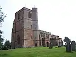 Church of St Peter |
| Church of St John the Baptist | Wolverley, Wolverley and Cookley, Wyre Forest | Parish Church | 1772 | 25 February 1958 | SO8288879317 52°24′42″N 2°15′11″W |
1348319 |  Church of St John the Baptist |
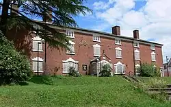
| Oak House, the Court House and the Old School House | Wolverley, Wolverley and Cookley, Wyre Forest | House | Late C20 | 25 February 1958 | SO8290579462 52°24′46″N 2°15′10″W |
1172811 | .jpg.webp) Oak House, the Court House and the Old School House |
| Wolverley House | Wolverley, Wolverley and Cookley, Wyre Forest | Apartment | Late C20 | 20 October 1952 | SO8301779619 52°24′51″N 2°15′04″W |
1172767 | Upload Photo |
| Caldwall Hall | Kidderminster, Wyre Forest | Castle | Late 15th century or early 16th century | 20 October 1952 | SO8308676227 52°23′02″N 2°15′00″W |
1179037 | _Tower%252C_Castle_Road%252C_Kidderminster_(geograph_2328286).jpg.webp) Caldwall Hall |
| Church of St George | Kidderminster, Wyre Forest | Church | 1821-4 | 20 October 1952 | SO8359476946 52°23′25″N 2°14′33″W |
1100088 | |
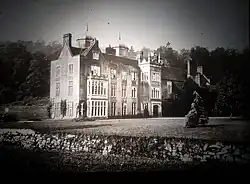
| Ribbesford House | Ribbesford, Wyre Forest | Mansion | 19th century | 20 October 1952 | SO786738 52°21′44″N 2°18′54″W |
1329928 |
.JPG.webp)
.jpg.webp)
.jpg.webp)
Notes
- The date given is the date used by Historic England as significant for the initial building or that of an important part in the structure's description.
- Sometimes known as OSGB36, the grid reference is based on the British national grid reference system used by the Ordnance Survey.
- The "List Entry Number" is a unique number assigned to each listed building and scheduled monument by Historic England.
References
External links
This article is issued from Wikipedia. The text is licensed under Creative Commons - Attribution - Sharealike. Additional terms may apply for the media files.