Grade I and Grade II* listed buildings in Middlesbrough (borough)
There are over 9,000 Grade I listed buildings and 20,000 Grade II* listed buildings in England. This page is a list of these buildings in the district of Middlesbrough in North Yorkshire.
Grade I
| Name | Location | Type | Completed [note 1] | Date designated | Grid ref.[note 2] Geo-coordinates |
Entry number [note 3] | Image |
|---|---|---|---|---|---|---|---|
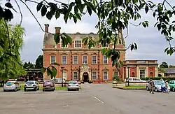
| Acklam Hall | Acklam | Country house | c. 1680 | 25 October 1951 | NZ4871716980 54°32′45″N 1°14′54″W |
1136868 |
Grade II*
| Name | Location | Type | Completed [note 1] | Date designated | Grid ref.[note 2] Geo-coordinates |
Entry number [note 3] | Image |
|---|---|---|---|---|---|---|---|
| Grey Towers House (Poole Hospital) and attached Wall | Nunthorpe, Middlesbrough | Country House | 1865-67 | 28 July 1988 | NZ5362813392 54°30′47″N 1°10′23″W |
1139813 | 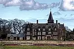 Grey Towers House (Poole Hospital) and attached Wall |
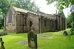
| Church of St. Peter and St. Paul | Stainton and Thornton, Middlesbrough | Church | 13th century | 23 June 1966 | NZ4804314050 54°31′10″N 1°15′34″W |
1137540 |  Church of St. Peter and St. Paul |
| Stainton Grange and Garden Walls | Stainton and Thornton, Middlesbrough | Farmhouse | Early/Mid 18th century | 23 June 1966 | NZ4904013736 54°31′00″N 1°14′38″W |
1329531 |  Upload Photo |
| Church of All Saints | Middlesbrough | Church | 1873-78 | 17 July 1968 | NZ4943220145 54°34′27″N 1°14′13″W |
1252480 | Upload Photo |
| Church of St John the Evangelist | Middlesbrough | Church | 1881/83 | 17 July 1968 | NZ5011120207 54°34′29″N 1°13′35″W |
1139854 |  Church of St John the Evangelist |
| Church of St. Cuthbert | Marton, Middlesbrough | Church | 12th century | 23 June 1966 | NZ5147115878 54°32′08″N 1°12′22″W |
1329502 | |
| Dock Clock Tower | Middlesbrough | Clock Tower | c. 1870 | 14 October 1999 | NZ5024820919 54°34′52″N 1°13′27″W |
1139871 | .jpg.webp) Dock Clock Tower |
| Empire Mecca Social Club | Middlesbrough | Social Club | 1896/99 | 28 July 1988 | NZ4966620350 54°34′33″N 1°14′00″W |
1329519 | .jpg.webp) Empire Mecca Social Club |
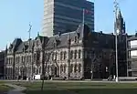
| Town Hall and Municipal Buildings | Middlesbrough | Local Government Office | 1883/89 | 17 July 1968 | NZ4960820334 54°34′33″N 1°14′03″W |
1136659 | |
| Middlesbrough Transporter Bridge | Middlesbrough | Transporter Bridge | 1911 | 28 July 1988 | NZ4996821260 54°35′03″N 1°13′42″W |
1139845 | |
| 7 Zetland Road | Middlesbrough | Office | 1881/91 | 13 February 1963 | NZ4954520634 54°34′43″N 1°14′06″W |
1312336 | Upload Photo |

Notes
- The date given is the date used by Historic England as significant for the initial building or that of an important part in the structure's description.
- Sometimes known as OSGB36, the grid reference is based on the British national grid reference system used by the Ordnance Survey.
- The "List Entry Number" is a unique number assigned to each listed building and scheduled monument by Historic England.
External links
![]() Media related to Grade II* listed buildings in the Borough of Middlesbrough at Wikimedia Commons
Media related to Grade II* listed buildings in the Borough of Middlesbrough at Wikimedia Commons
This article is issued from Wikipedia. The text is licensed under Creative Commons - Attribution - Sharealike. Additional terms may apply for the media files.