County of Bentheim (district)
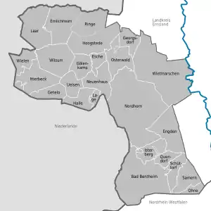
County of Bentheim (German: Grafschaft Bentheim) is a district (Landkreis) in Lower Saxony, Germany. It is bounded by (from the west and clockwise) the Dutch provinces of Overijssel and Drenthe, the district of Emsland, and the districts of Steinfurt and Borken in North Rhine-Westphalia.
Grafschaft Bentheim | |
|---|---|
 Flag 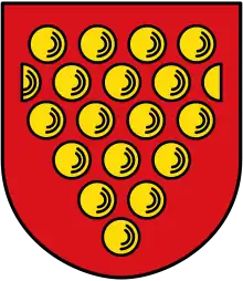 Coat of arms | |
| Country | Germany |
| State | Lower Saxony |
| Capital | Nordhorn |
| Area | |
| • Total | 981 km2 (379 sq mi) |
| Population (31 December 2021)[1] | |
| • Total | 138,722 |
| • Density | 140/km2 (370/sq mi) |
| Time zone | UTC+01:00 (CET) |
| • Summer (DST) | UTC+02:00 (CEST) |
| Vehicle registration | NOH |
| Website | grafschaft.de |
History
The District has roughly the same territory as the County of Bentheim, a state of the Holy Roman Empire that was dissolved in 1803.
Geography

The district's north-western region named Niedergrafschaft (low county) protrudes into Dutch territory, and borders it to the north, west and south. The Vechte River (Dutch Vecht) traverses the district from south to north and flows into the Netherlands.
Coat of arms
The arms are identical to the arms of the historic County of Bentheim. The origin of these arms is unknown.
Towns and municipalities
| Towns | Samtgemeinden | |
|---|---|---|
|
|
|
|
| 1seat of the Samtgemeinde; ²town | ||
References
External links
- Official website (in German)
| Region | |
|---|---|
| Urban districts | |
| Rural districts |
|
Districts of German states (Full list)
| |