Greater Kuril Chain
Greater Kuril Chain (Russian: Большая Курильская гряда) - a part of the Kuril Islands[1] - is a group of islands in the Pacific Ocean. It includes North Kurils, Iturup and Kunashir.
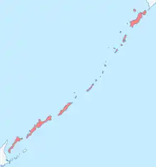
At its south western end, the Greater Kuril Chain is separated from the Lesser Kuril Chain by the South Kuril Strait. The maximum altitude in the Greater Kuril Chain is 2339m, on (Atlasov Island).
Length - 1200 km. Total Area - 10,100 km².
Greater Kuril Chain is part of Sakhalin Oblast of Russia. In the southern group of islands, Iturup and Kunashir are under Russian control, but this is disputed by Japan.
| Name | Area, km² |
Maximum height, m |
Latitude | Longitude | |
|---|---|---|---|---|---|
| Northern group | |||||
| Atlasov Island | 150 | 2339 | 50°52' | 155°34' | |
| Shumshu | 388 | 189 | 50°45' | 156°21' | |
| Paramushir | 2053 | 1816 | 50°23' | 155°41' | |
| Antsiferov Island | 7 | 747 | 50°12' | 154°59' | |
| Makanrushi | 49 | 1169 | 49°46' | 154°26' | |
| Onekotan | 425 | 1324 | 49°27' | 154°46' | |
| Kharimkotan | 68 | 1157 | 49°07' | 154°32' | |
| Chirinkotan | 6 | 724 | 48°59' | 153°29' | |
| Ekarma | 30 | 1170 | 48°57' | 153°57' | |
| Shiashkotan | 122 | 934 | 48°49' | 154°06' | |
| Middle group | |||||
| Raikoke | 4,6 | 551 | 48°17' | 153°15' | |
| Matua (island) | 52 | 1446 | 48°05' | 153°13' | |
| Rasshua | 67 | 948 | 47°45' | 153°01' | |
| Ushishir | 5 | 388 | — | — | |
| Ryponkicha | 1,3 | 121 | 47°32' | 152°50' | |
| Yankicha | 3,7 | 388 | 47°31' | 152°49' | |
| Ketoy | 73 | 1166 | 47°20' | 152°31' | |
| Simushir | 353 | 1539 | 46°58' | 152°00' | |
| Broutona | 7 | 800 | 46°43' | 150°44' | |
| Chyornye Bratya | 37 | 749 | — | — | |
| Chirpoy | 21 | 691 | 46°30' | 150°55' | |
| Brat Chirpoyev | 16 | 749 | 46°28' | 150°50' | |
| Southern group | |||||
| Urup | 1450 | 1426 | 45°54' | 149°59' | |
| Iturup | 3200 | 1634 | 45°00' | 147°53' | |
| Kunashir | 1490 | 1819 | 44°05' | 145°59' | |
References
- "GSE Kurile Islands Sand Lake (Kunashir Island) Fish processing base (Shikotan island) Kurilskie Ostrova". slovari.yandex.ru. Archived from the original on 2013-04-24. Retrieved 2020-02-26.
This article is issued from Wikipedia. The text is licensed under Creative Commons - Attribution - Sharealike. Additional terms may apply for the media files.