Gschnitzbach
The Gschnitzbach is a river of Tyrol, Austria.
| Gschnitzbach | |
|---|---|
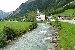 The Geschnitzbach in Gschnitz | |
| Location | |
| Country | Austria |
| State | Tyrol |
| Physical characteristics | |
| Source | |
| • location | out of the lake Lauterersee |
| Mouth | |
• location | into the Sill at Steinach am Brenner |
• coordinates | 47.0940°N 11.4672°E |
| Length | ~ 20 km (12 mi)[1] |
| Basin features | |
| Progression | Sill→ Inn→ Danube→ Black Sea |
The Gschnitzbach springs from the lake Lauterersee in the Stubai Alps.[1] It flows from South to North and merges with the Sill at Steinach am Brenner.[2] It has a length of about 20 kilometres (12 mi)[1] and passes through the villages of Trins and Gschnitz.[3]
The water quality of the Gschnitzbach is A grade and remains very clear until the mouth. It provides a good living space for fishes. The water is also used for drinking water supply for the villages nearby.
The river may look like a silent water upstream, but quickly turns into a rapid-river spiked with several dangerous chutes in its lower course.
References
- "Mounaineering village Gschnitztal". Bergsteiger Dörfer. Bergsteigerdörfer. Retrieved 7 March 2020.
- Google (7 March 2020). "Gschnitzbach mouth" (Map). Google Maps. Google. Retrieved 7 March 2020.
- Google (7 March 2020). "valley of the Gschnitzbach" (Map). Google Maps. Google. Retrieved 7 March 2020.
This article is issued from Wikipedia. The text is licensed under Creative Commons - Attribution - Sharealike. Additional terms may apply for the media files.