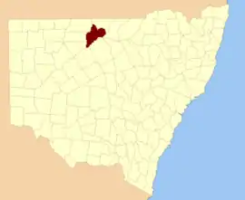
Gunderbooka County

Gunderbooka County is one of the 141 Cadastral divisions of New South Wales.

Gunderbooka
New South Wales
Location in New South Wales
Lands administrative divisions around Gunderbooka:
Irrara Culgoa Culgoa
Barrona Gunderbooka Narran
Landsborough Yanda Cowper

Geography

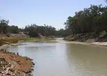
The Warrego River is the western boundary, and the Culgoa River and Darling River is the south-eastern boundary. It includes the area down to where the Warrego meets the Darling, to the north of Bourke (including North Bourke).

The village of Ford's Bridge,the town of Engonnia and Burke all lie just outside the county with North Bourke being the only settlement currently in the county. The entirety of the county is incorporated, with the seat of government being located in Bourke.

The Darling River is the boundary between Gunderbooka and Cowper.

Etymology

Gunderbooka is believed to be derived from a local Aboriginal word and is also the name of Gundabook Station.[1]

History

The area occupied by the country was the traditional lands of three groups of Aboriginal tribes.

Living In the west of the County along the Warrego river, were the Gunu people, living in the south along the flood plain of the Darling River were the Barranbidgee people with the Wangoibon tribes living on the adjacent river bank of the Darling River, in what is today Cowper Country.

In the north of the County lived the Manuwari people.

The first Europeans to the County were the expedition of Charles Sturt in 1828. Followed by the expedition of Thomas Mitchell in 1835.

Poet Henry Lawson came to the Country walking from Bourke to Hungerford in 1892.

Landscape of Coooer Parish in Gunderbooka Country

And another poet, Oglevy coined the phrase "Back of Burke" to describe the remoteness of the northern part of the country during his time working in Engonnia in the years around Federation.

Parishes within this county

A full list of parishes found within this county; their current LGA and mapping coordinates to the approximate centre of each location is as follows:

ParishLGACoordinates
AripilisBourke Shire30°17′04″S 145°30′52″E
BibildoolieBourke Shire29°38′50″S 145°46′40″E
BookaBourke Shire30°04′00″S 145°27′42″E
BothadoolaBourke Shire30°02′43″S 145°34′43″E
BoyongBourke Shire30°09′40″S 145°44′44″E
BrandisBourke Shire29°53′49″S 145°57′50″E
BullamuntaBourke Shire30°00′33″S 145°58′14″E
CoolamonBourke Shire29°45′12″S 145°41′28″E
CooningBourke Shire29°33′28″S 146°09′30″E
CooperBourke Shire29°49′55″S 145°44′16″E
CourallieBourke Shire29°36′50″S 145°54′42″E
CumbookaBourke Shire29°42′53″S 146°17′55″E
CuttabullaBourke Shire29°28′28″S 145°57′10″E
DarlingBourke Shire29°42′22″S 146°04′40″E
Fords BridgeBourke Shire29°50′53″S 145°29′45″E
FranklinBourke Shire30°06′25″S 145°40′43″E
GalarBourke Shire29°43′23″S 145°44′43″E
GoldsonBourke Shire29°49′12″S 146°02′52″E
GreigBourke Shire29°51′28″S 145°57′58″E
LedknapperBourke Shire29°35′32″S 146°13′26″E
LeilaBourke Shire29°29′33″S 145°48′26″E
LoodenBourke Shire29°50′10″S 146°14′11″E
MooramiaBourke Shire29°49′41″S 145°52′20″E
MumpberBourke Shire30°11′14″S 145°30′50″E
MungunyahBourke Shire29°24′54″S 145°51′06″E
Nellys SpringsBourke Shire29°35′35″S 146°03′20″E
NidgerieBourke Shire29°58′56″S 145°40′42″E
North BourkeBourke Shire30°02′45″S 145°56′33″E
NultyBourke Shire30°12′35″S 145°38′01″E
PakaBourke Shire30°02′49″S 145°43′30″E
PalmerBourke Shire29°45′17″S 146°09′54″E
PeraBourke Shire30°03′54″S 145°52′24″E
PoloBourke Shire29°58′45″S 145°47′09″E
QuondongBourke Shire29°46′02″S 146°25′59″E
SutherlandBourke Shire29°53′48″S 145°37′33″E
TalaaBourke Shire30°00′33″S 145°52′02″E
TobinBourke Shireunknown
TooraleBourke Shire30°16′40″S 145°25′30″E
TresillianBourke Shire29°46′22″S 145°53′50″E
TullyBourke Shire29°52′04″S 146°08′32″E
TureeBourke Shire29°54′43″S 146°06′02″E
WarraweenaBourke Shire29°55′33″S 146°15′56″E
WommeraBourke Shire29°57′01″S 145°35′47″E
YarramanBourke Shire29°40′53″S 146°21′15″E
YuronganBourke Shire29°37′19″S 146°13′29″E

References

  1. "Gunderbooka". Geographical Names Register (GNR) of NSW. Geographical Names Board of New South Wales. Retrieved 6 January 2012.
This article is issued from Wikipedia. The text is licensed under Creative Commons - Attribution - Sharealike. Additional terms may apply for the media files.