Habibas Islands
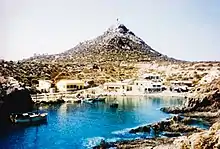
The Habibas islands ( Arabic: جزر حبيبة) 35°43′29″N 1°8′00″W are located about 12 km off the Algerian coast, northwest of Oran. The islands consist of a principal island 1.3 km long surrounded by an archipelago covering a total area of about 40 ha.[4] The highest point on the Habibas islands reaches 105 m. The islands are of volcanic origin.
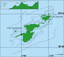
 Iles Habibas Lighthouse in 1960 | |
| Location | Iles Habibas Algeria |
|---|---|
| Coordinates | 35°43′14.0″N 1°8′00.23″W |
| Tower | |
| Constructed | 1878[1] |
| Construction | masonry tower |
| Height | 13.8 metres (45 ft)[1] |
| Shape | quadrangular tower with balcony and lantern atop 1-storey keeper’s house[2] |
| Markings | white tower, |
| Power source | solar power |
| Operator | Office Nationale de Signalisation Maritime |
| Light | |
| Focal height | 113.3 metres (372 ft)[1] |
| Intensity | 180 W[1] |
| Range | 20 nautical miles (37 km; 23 mi)[1] |
| Characteristic | Fl W 5s.[3] |
The Habibas islands fall under the Bou Zedjar municipality in the Aïn Témouchent Province, Algeria. There are no permanent population centres, but there is a small jetty, a lighthouse (built in 1879) and a few small buildings. The islands make up the Iles Habibas Marine Nature Reserve.[4]
By the end of 2006, a project to rehabilitate and maintain the island was to commence, backed by Algerian and French funding. The stated objective was to support the local ecosystem.[5]
See also
References
- "Ile Habibas". Office Nationale de Signalisation Maritime. Ministere des Travaux Publics. Retrieved 30 April 2017.
- Rowlett, Russ. "Lighthouses of Western Algeria". The Lighthouse Directory. University of North Carolina at Chapel Hill. Retrieved 30 April 2017.
- List of Lights, Pub. 113: The West Coasts of Europe and Africa, the Mediterranean Sea, Black Sea and Azovskoye More (Sea of Azov) (PDF). List of Lights. United States National Geospatial-Intelligence Agency. 2015.
- "Iles Habibas Marine Nature Reserve".
- "Visit Oran | Habibas Island Development". Archived from the original on 2013-12-03. Retrieved 2011-12-09.