Hadoti
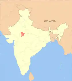
Hadoti is a region of Rajasthan state in western India, which was once called the Bundi Kingdom. The biggest cities are Jhalawar and Kota. It includes the districts of Bundi, Baran, Jhalawar and Kota and is bounded on the west by the Mewar, on the northwest by Ajmer regions of Rajasthan, and on the south by the Malwa, on the east by the Gird regions of Madhya Pradesh state.
Hadoti | |
|---|---|
 | |
| Country | India |
| State | Rajasthan |
| Districts | |
| Languages | Hadoti, Malvi, Hindi |
| Area | |
| • Total | 24,204 km2 (9,345 sq mi) |
| Population (2011) | |
| • Total | 5,695,804 |
| • Density | 240/km2 (610/sq mi) |
| Largest City | |
Geography
The region of south eastern Rajasthan lies between Malwa Plateau in the east, Aravali range in the west and Marwar plateau in the west south side, on the border with Madhya Pradesh. The major river is the Chambal River, with its tributaries Kaalisindh, Parvati, Parwan and Chapi. The soil is alluvial.
Princely states of Hadoti
- Palaitha - Hada Chauhan Maharaja's
- Moondli - Hada Maharaja's
- Kunadi -
- Bamulia - Hada Maharaja's
- Kachnoada - Hada
- Rajgarh - Hada
- Ghati - Hada
- Kherli - Tanwar
- Srinal - Tanwar
- Koela - Hada Chauhan
- Dabri - Hada
- Kherli - Hada Maharaja's
- Karwar - Hada
- Phasud - Hada
- Pipalda - Hada
- Antarda - Hada
- Nimola - Hada
- Sarola - Pandit Brahmins
- Harnawada - Sirohiya Rao Raja
- Akawad Khurd - Rathore
Demographics
Religion
The vast majority of the population are Hindu. Muslims form the largest minority and are largely concentrated in urban areas.
References
- http://censusindia.gov.in/. Retrieved 1 December 2021.
{{cite web}}: Missing or empty|title=(help) - "Census of India Website : Office of the Registrar General & Census Commissioner, India". Archived from the original on 15 August 2018. Retrieved 26 April 2019.